
A | B | C | D | E | F | G | H | CH | I | J | K | L | M | N | O | P | Q | R | S | T | U | V | W | X | Y | Z | 0 | 1 | 2 | 3 | 4 | 5 | 6 | 7 | 8 | 9
Odesa
Одеса Odessa | |
|---|---|
 Clockwise from top left: Vorontsov Lighthouse; Monument to the Duc de Richelieu; Potemkin Stairs; Square de Richelieu; Opera and Ballet Theatre; and city garden | |
 | |
| Coordinates: 46°29′8.6″N 30°44′36.4″E / 46.485722°N 30.743444°E | |
| Country | |
| Oblast | Odesa Oblast |
| Raion | Odesa Raion |
| Hromada | Odesa urban hromada |
| First mentioned | 19 May 1415 |
| Government | |
| • Mayor | Gennadiy Trukhanov[1] (Truth and Deeds[2]) |
| Area | |
| • City | 162.42 km2 (62.71 sq mi) |
| • Metro | 3,656 km2 (1,412 sq mi) |
| Elevation | 40 m (130 ft) |
| Highest elevation | 65 m (213 ft) |
| Lowest elevation | −4.2 m (−13.8 ft) |
| Population (2022) | |
| • City | 1,010,537 |
| • Rank | 3rd in Ukraine |
| • Density | 6,200/km2 (16,000/sq mi) |
| • Metro | 1,378,490[3] |
| Demonym(s) | English: Odesan, Odesite, Odessan, Odessite Ukrainian: одесит, одеситка Russian: одессит, одесситка |
| Time zone | UTC+2 (EET) |
| • Summer (DST) | UTC+3 (EEST) |
| Postal codes | 65000–65480 |
| Area code | +380 48 |
| Website | www.omr.gov.ua/en/ |
| Official name | The Historic Centre of Odesa |
| Type | Cultural |
| Criteria | II and IV |
| Designated | 2023 (18th extraordinary World Heritage Committee session) |
| Reference no. | 1703 |
| UNESCO region | Europe |
| Endangered | 2023– |
Odesa (also spelled Odessa)[a] is the third most populous city and municipality in Ukraine and a major seaport and transport hub located in the south-west of the country, on the northwestern shore of the Black Sea. The city is also the administrative centre of the Odesa Raion and Odesa Oblast, as well as a multiethnic cultural centre. As of January 2021, Odesa's population was approximately 1,010,537.[6] On 25 January 2023, its historic city centre was declared a World Heritage Site and added to the List of World Heritage in Danger by the UNESCO World Heritage Committee in recognition of its influence on cinema, literature, and the arts.[7][8] The declaration was made in response to the bombing of Odesa during the 2022 Russian invasion of Ukraine, which has damaged or destroyed buildings across the city.
In classical antiquity a large Greek settlement existed at its location no later than the middle of the 6th century BC. It has been researched as a possible site of the ancient Greek settlement of Histria.
The first chronicle mention of the Slavic settlement-port of Kotsiubijiv, which was part of the Grand Duchy of Lithuania, dates back to 1415, when a ship was sent from here to Constantinople by sea.[9][10] After the Grand Duchy lost control, the port and its surroundings became part of the domain of the Ottoman Empire in 1529, under the name Hacibey, and remained in it until the Ottomans' defeat in the Russo-Turkish War (1787–1792).
In 1794, a decree of the Russian empress Catherine II was issued to establish a navy harbor and trading place in Khadjibey, which was named Odessa soon after.[11][12] From 1819 to 1858, Odesa was a free port. During the Soviet period, it was an important trading port and a naval base.
During the 19th century, Odesa was the fourth largest city of the Russian Empire, after Moscow, Saint Petersburg and Warsaw.[13] Its historical architecture is more Mediterranean than Russian, having been heavily influenced by French and Italian styles. Some buildings are built in a mixture of different styles, including Art Nouveau, Renaissance and Classicist.[14]
Odesa is a warm-water port. The city of Odesa hosts both the Port of Odesa and Port Pivdennyi, a significant oil terminal situated in the city's suburbs. Another notable port, Chornomorsk, is located in the same oblast, to the south-west of Odesa. Together they represent a major transport hub integrating with railways. Odesa's oil and chemical processing facilities are connected to the Russian and other European networks by strategic pipelines. In 2000, the Quarantine Pier at Odesa Commercial Sea Port was declared a free port and free economic zone for a period of 25 years.
Name
- English: Odesa or Odessa /oʊˈdɛsə/ oh-DESS-ə[15]
- Ukrainian: Одеса, romanized: Odesa [oˈdɛsɐ] ⓘ
- Russian: Одесса, romanized: Odessa [ɐˈdʲes(ː)ə] ⓘ
- Greek: Οδησσός, romanized: Odissós
- Yiddish: אָדעס, romanized: Odes
- Romanian: Odesa
Odesa is sometimes called the Pearl by the Sea,[16] the Southern Capital,[17] Odesa-mama and the Humour Capital, as well as Southern Palmyra.[18]
In 1795 the city was named Odessa in accordance with the Greek Plan of Empress Catherine II. Catherine's Secretary of State Adrian Gribovsky claimed in his memoirs that the name was his suggestion. Some expressed doubts about this claim, while others noted the reputation of Gribovsky as an honest and modest man.[19] Odesa is located between the ancient Greek cities of Tyras and Olbia[20] and it was named using a Slavic feminine form for the ancient Greek city of Odessos (Ancient Greek: Ὀδησσός; in Roman times, Odessus). This refers to the second ancient Odessos, founded between the end of the 5th and beginning of the 4th centuries BC (the first one, identified with modern Varna in Bulgaria, is the older of the two, founded c. 610 BC). The exact location of this ancient Odessos is unknown, but modern efforts have attempted to localize it 40 km northeast of Odesa, near the village of Koshary, Odesa Oblast.,[21] near the Tylihul Estuary.[22]
Odessa, the transliteration of the name from Russian, was the traditional English spelling of the city's name favoured before Ukraine's independence in 1991 (similarly to the spelling of Kyiv versus Kiev).
Odesa became the internationally standardized Latin-alphabet transliteration of the Ukrainian name according to the Ukrainian National romanization system, which was adopted for official use by Ukraine's cabinet in 2010, approved by the UN Group of Experts on Geographical Names in 2012, and adopted by the BGN/PCGN in 2019.[23][24][25][26] This spelling appears in Encyclopædia Britannica[27] and in dictionaries as the spelling for the Ukrainian city.[28][29][30][31] As noted by the Christian Science Monitor, many in the English-language media outlets historically spelled the city Odessa, even after changing the spelling of Kiev to Kyiv, but since the beginning of Russia's 2022 invasion of Ukraine more outlets[4][5] and style guides[32][33][34] have been shifting away from Russian transliterations.
History
Grand Duchy of Lithuania 1415-1484
Ottoman Empire 1484-1789
Russian Empire 1789-1917
Beginning of 1917-1921 revolution
Russian Provisional Government 1917
UPR dec 1917-nov 1918
OSR jan-mar 1918
Ukrainian State mar-dec 1918
AFSR dec 1918-apr 1919
PWPGU/
UkSSR apr-aug 1919
AFSR aug 1919-feb 1920
/
/
UkSSR feb 1920-dec 1922
End of the 1917-1921 revolution
USSR 1922-1941
Kingdom of Romania 1941-1944
USSR 1944-1991
Ukraine 1991-to this day
Early history

Odesa was the site of a large Greek settlement no later than the middle of the 6th century BC (a necropolis from the 5th–3rd centuries BC has long been known in this area). Some scholars believe it to have been a trade settlement established by the Greek city of Histria. Whether the Bay of Odesa is the ancient "Port of the Histrians" cannot yet be considered a settled question based on the available evidence.[36] Archaeological artifacts confirm extensive links between the Odesa area and the eastern Mediterranean.
In the Middle Ages successive rulers of the Odesa region included various nomadic tribes (Petchenegs, Cumans), the Golden Horde, the Crimean Khanate, the Grand Duchy of Lithuania, and the Ottoman Empire. Yedisan Crimean Tatars traded there in the 14th century.
Since the middle of the 13th century the city's territory belonged to the Golden Horde domain.[37] On Italian navigational maps of 14th century on the place of Odesa is indicated the castle of Ginestra, at the time the center of a Gazarian colony of the Republic of Genoa.[37] During the reign of Khan Hacı I Giray of Crimea (1441–1466), the Khanate was endangered by the Golden Horde and the Ottoman Turks and, in search of allies, the khan agreed to cede the area to Lithuania. The site of present-day Odesa was then a fortress known as Khadjibey (named for Hacı I Giray, and also spelled Kocibey in English, Hacıbey or Hocabey in Turkish, and Hacıbey in Crimean Tatar). Khadjibey was first mentioned in 1415 in Polish chronicles by Jan Długosz, when a ship with grain sailed from there to Constantinople.[38][37] By the middle of the 15th century, the settlement was depopulated.[37]
Ottoman conquest
Khadjibey came under direct control of the Ottoman Empire after 1529.[37] In the mid-18th century, the Ottomans rebuilt the fortress at Khadjibey (also known as Hocabey), which was named Yeni Dünya[37] (literally "New World").
Russian conquest of Sanjak of Özi (Ochakiv Oblast)
A series of wars between the Russian Empire and the Ottoman Empire, as well as the demise of the Polish-Lithuanian Commonwealth, allowed Russia to start to fully exploit the ancient Black Sea trade across the coastal area through the steppe across southern and eastern Ukraine, into the hinterland of East Central Europe. Stable commercial activity in this region in practice in the past required both security through the overland routes, and knowledge of where products could go overseas. In antiquity, various Greek colonies had taken this role, followed by the Varangians who established Kievan Rus' in the 9th century, as well as various Italian colonies after the Mongol invasion of Europe.[22]: 1-3 Under Catherine the Great, Russia gained, via the Treaty of Küçük Kaynarca, the lands where Mariupol, Kherson, and Mykolaiv would be founded. However, they were all handicapped in various ways relative to how much commercial interest there was. For example, the latter two cities were situated in lowlands near marshes, which provided for poor sanitary conditions in the technology available at that time. [22]: 5

The sleepy fishing village of Odesa had witnessed a sea-change in its fortunes when the wealthy magnate and future Voivode of Kiev (1791), Antoni Protazy Potocki, established trade routes through the port for the Polish Black Sea Trading Company and set up the infrastructure in the 1780s.[39]
During the Russian-Turkish War of 1787–1792,[37] on 25 September 1789, a detachment of Russian forces, including Zaporozhian Cossacks under Alexander Suvorov and Ivan Gudovich, took Khadjibey and Yeni Dünya for the Russian Empire. One section of the troops came under command of a Spaniard in Russian service, Irishman Major General José de Ribas (known in Russia as Osip Mikhailovich Deribas); today, the main street in Odesa, Deribasivska Street, is named after him.
Russia formally gained possession of the Sanjak of Özi (Ochakiv Oblast)[40] as a result of the Treaty of Jassy (Iaşi)[37] in 1792 and it became a part of Yekaterinoslav Viceroyalty. The Russian Empire took full control of Crimea, as well as land between the Southern Bug and the Dniester, including the Khadzhibey Estuary where the Turkish fortress of Khadjibey was located. The newly acquired Ochakov Oblast was promised to the Cossacks by the Russian government for resettlement.[41] On permission of the Archbishop of Yekaterinoslav Amvrosiy, the Black Sea Kosh Host, that was located around the area between Bender and Ochakiv, built second after Sucleia wooden church of Saint Nicholas.[42][clarification needed]
By the Highest[clarification needed] rescript of 17 June 1792 addressed to General Kakhovsky it was ordered to establish the Dniester Border Line of fortresses.[42] The commander of the land forces in Ochakiv Oblast was appointed Graf (Count) Suvorov-Rymnikskiy.[42] The main fortress was built near Sucleia at the mouth of river Botna as the Head Dniester Fortress by Engineer-Major de Wollant.[42] Near the new fortress saw the formation of a new "Vorstadt" (suburb) where people moved from Sucleia and Parkan.[42] With the establishment of the Voznesensk Governorate on 27 January 1795, the Vorstadt was named Tiraspol.[42]
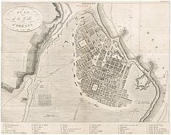
The Flemish engineer working for the Russian Empress Catherine the Great, José de Ribas's collaborator Franz de Voland recommended the area of Khadjibey fortress as the site for the region's basic port: it had an ice-free harbor, breakwaters could be cheaply constructed that would render the harbor safe and it would have the capacity to accommodate large fleets. The Namestnik of Yekaterinoslav and Voznesensk, Platon Zubov (one of Catherine's favorites), supported this proposal. In 1794 Catherine issued a Rescript to José de Ribas: "Considering favorable Khadjibey location... I order to establish here a navy harbor and trading pierce..." and invested the first money (26.000 rubles) in construction. Franz de Voland drew up a plan that would end up being the city's plan.[22]: 7
However, adjacent to the new official locality, a Moldavian colony already existed, which by the end of the 18th century was an independent settlement named Moldavanka. Some local historians consider that the settlement predates Odesa by about thirty years and assert that the locality was founded by Moldavians who came to build the fortress of Yeni Dunia for the Ottomans and eventually settled in the area in the late 1760s, right next to the settlement of Khadjibey, on what later became the Primorsky Boulevard. Another version posits that the settlement appeared after Odesa itself was founded, as a settlement of Moldavians, Greeks, and Albanians fleeing the Ottoman yoke.[43]
Under Paul I of Russia, construction of Odesa was stopped, Franz de Voland was removed from the project, and José de Ribas was implicated in a plot to assassinate the Emperor. After Paul's assassination in 1801, the city resumed construction, and used a plan largely from de Voland's work. It was thus one of the few master planned cities in the Russian Empire. [22]: 13
Renaming of the settlement and establishment of sea port
In 1795, Khadjibey was officially renamed with the feminine name "Одесса (Odessa)" after a Greek colony of Odessos that supposedly was located in the area. The first census that was conducted in Odesa was in 1797 which accounted for 3,455 people.[37] Since 1795, the city had its own city magistrate, and since 1796 a city council of six members and the Odesa Commodity Exchange.[37] In 1801, in Odesa had opened the first commercial bank.[37] In 1803, the city accounted for 9,000 people.[44]
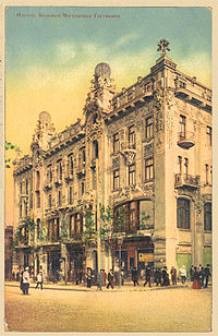

In their settlement, also known as Novaya Slobodka, the Moldavians owned relatively small plots on which they built village-style houses and cultivated vineyards and gardens. What became Mykhailovsky Square was the center of this settlement and the site of its first Orthodox church, the Church of the Dormition, built in 1821 close to the seashore, as well as a cemetery. Nearby stood the military barracks and the country houses (dacha) of the city's wealthy residents, including that of the Duc de Richelieu, appointed by Tsar Alexander I as Governor of Odesa in 1803.[45] Richelieu played a role during Ottoman plague epidemic which hit Odesa in the autumn 1812.[46][47] Dismissive of any attempt to forge a compromise between quarantine requirements and free trade, Prince Kuriakin (the Saint Petersburg-based High Commissioner for Sanitation) countermanded Richelieu's orders.[48]
In the period from 1795 to 1814, the population of Odesa increased 15 times over and reached almost 20 thousand people. The first city plan was designed by the engineer F. Devollan in the late 18th century.[14] Colonists of various ethnicities settled mainly in the area of the former colony, outside of the official boundaries, and as a consequence, in the first third of the 19th century, Moldavanka emerged as the dominant settlement. After planning by the official architects who designed buildings in Odesa's central district, such as the Italians Francesco Carlo Boffo and Giovanni Torricelli (see Italians of Odesa), Moldovanka was included in the general city plan, though the original grid-like plan of Moldovankan streets, lanes, and squares remained unchanged.[43]
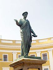
The new city quickly became a major success although initially, it received little state funding and privileges.[49] Its early growth owed much to the work of the Duc de Richelieu, who served as the city's governor between 1803 and 1814. Having fled the French Revolution, he had served in Catherine's army against the Turks. He is credited with designing the city and organizing its amenities and infrastructure, and is considered[by whom?] one of the founding fathers of Odesa, together with another Frenchman, Count Andrault de Langeron, who succeeded him in office.
Richelieu is commemorated by a bronze statue, unveiled in 1828 to a design by Ivan Martos. His contributions to the city are mentioned by Mark Twain in his travelogue Innocents Abroad: "I mention this statue and this stairway because they have their story. Richelieu founded Odessa – watched over it with paternal care – labored with a fertile brain and a wise understanding for its best interests – spent his fortune freely to the same end – endowed it with a sound prosperity, and one which will yet make it one of the great cities of the Old World".
In 1819, Odesa became a free port, a status it retained until 1859. Odesa became home to an extremely diverse population of Albanians, Armenians, Azeris, Bulgarians, Crimean Tatars, Frenchmen, Germans (including Mennonites), Greeks, Italians, Jews, Poles, Romanians, Russians, Turks, Ukrainians, and traders representing many other nationalities (hence numerous "ethnic" names on the city's map, for example Frantsuzky (French) and Italiansky (Italian) Boulevards, Grecheskaya (Greek), Yevreyskaya (Jewish), Arnautskaya (Albanian) Streets).
The Filiki Eteria, a Greek freemasonry-style society that was to play an important role in the Greek War of Independence, was founded in Odesa in 1814 before relocating to Constantinople in 1818. Odesa's cosmopolitan nature was documented by the great Russian poet Alexander Pushkin, who lived in internal exile in Odesa between 1823 and 1824. In his letters, he wrote that Odesa was a city where "the air is filled with all Europe, French is spoken and there are European papers and magazines to read".
Odesa's growth was interrupted by the Crimean War of 1853–1856, during which it was bombarded by British and Imperial French naval forces.[50] It soon recovered and the growth in trade made Odesa Russia's largest grain-exporting port. In 1866, the city was linked by rail with Kyiv and Kharkiv as well as with Iaşi in Romania.
The city became the home of a large Jewish community during the 19th century, and by 1897 Jews were estimated to comprise some 37% of the population. The community, however, was repeatedly subjected to anti-Semitism and anti-Jewish agitation from almost all Christian segments of the population.[51] Pogroms were carried out in 1821, 1859, 1871, 1881 and 1905. Many Odesan Jews fled abroad after 1882, particularly to the Ottoman region that became Palestine, and the city became an important base of support for Zionism.
Beginnings of revolution

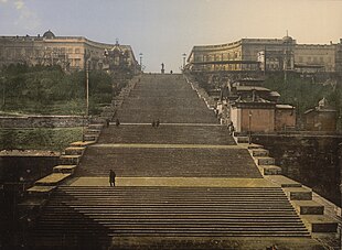
In 1905, Odesa was the site of a workers' uprising supported by the crew of the Russian battleship Potemkin and the Menshevik's Iskra. Sergei Eisenstein's famous motion picture The Battleship Potemkin commemorated the uprising and included a scene where hundreds of Odesan citizens were murdered on the great stone staircase (now popularly known as the "Potemkin Steps"), in one of the most famous scenes in motion picture history. At the top of the steps, which lead down to the port, stands a statue of the Duc de Richelieu.[52]
The actual massacre took place in streets nearby, not on the steps themselves, but the film caused many to visit Odesa to see the site of the "slaughter". The "Odesa Steps" continue to be a tourist attraction in Odesa. The film was made at Odesa's Cinema Factory, one of the oldest cinema studios in the former Soviet Union.[52]
Following the Bolshevik Revolution in 1917 during Ukrainian-Soviet War, Odesa saw two Bolshevik armed insurgencies, the second of which succeeded in establishing their control over the city; for the following months, the city became a center of the Odesa Soviet Republic. After signing of the Brest-Litovsk Treaty all Bolshevik forces were driven out by 13 March 1918 by the combined armed forces of the Austro-Hungarian Army, providing support to the Ukrainian People's Republic.[52]
With the end of the World War I and the withdrawal of armies of Central Powers, the Soviet forces fought for control over the country with the army of the Ukrainian People's Republic. A few months later the city was occupied by the French Army and the Greek Army that supported the Russian White Army in its struggle with the Bolsheviks. The Ukrainian general Nykyfor Hryhoriv who sided with Bolsheviks managed to drive the Triple Entente forces out of the city, but Odesa was soon retaken by the Russian White Army. By 1920 the Soviet Red Army managed to overpower both the Ukrainian and Russian White Army and secure the city.
The people of Odesa suffered badly from a famine that resulted from the Russian Civil War in 1921–1922 due to the Soviet policies of prodrazverstka. In 1937, around 1,000 Poles were executed in Odesa during the Polish Operation of the NKVD.[53]
World War II

During World War II, Odesa was attacked by Romanian and German troops in August 1941. The defense of Odesa started on 5 August 1941 and lasted for 73 days. The defense was organized on three lines with emplacements consisting of trenches, anti-tank ditches and pillboxes. The first line was 80 kilometres (50 miles) long and situated some 25 to 30 kilometres (16 to 19 miles) from the city. The second and main line of defense was situated 6 to 8 kilometres (3.7 to 5.0 miles) from the city and was about 30 kilometres (19 miles) long. The third and last line of defense was organized inside the city itself. Lyudmila Pavlichenko, the famous female sniper, took part in the battle for Odesa. She recorded 187 confirmed kills during the defense of Odesa. Pavlichenko's confirmed kills during World War II totaled 309 (including 36 enemy snipers).
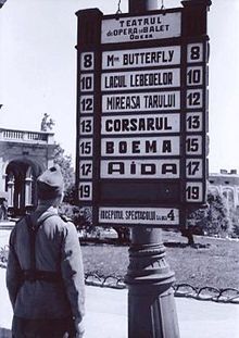
The city fell to the Axis on 16 October 1941,[54] and it was henceforth subject to Romanian administration. By that time, the Soviet authorities had been able to evacuate 200,000 people as well as weaponry and industrial equipment.[55] A day later, Odesa was made the capital of Transnistria.[56] Partisan fighting continued, however, in the city's catacombs.
Following the siege, and the Axis occupation, approximately 25,000 Odesans were murdered in the outskirts of the city and over 35,000 deported; this came to be known as the Odesa massacre. Most of the atrocities were committed during the first six months of the occupation which officially began on 17 October 1941, when 80% of the 210,000 Jews in the region were killed,[57] compared to Jews in Romania proper where the majority survived.[58] After the Nazi forces began to lose ground on the Eastern Front, the Romanian administration changed its policy, refusing to deport the remaining Jewish population to extermination camps in German occupied Poland, and allowing Jews to work as hired labourers. As a result, despite the events of 1941, the survival of the Jewish population in this area was higher than in other areas of occupied eastern Europe.[57]
A Soviet medal, "For the Defence of Odesa", was established on 22 December 1942. It was one of the first four Soviet cities to be awarded the title of "Hero City" in 1945. (The others were Leningrad, Stalingrad, and Sevastopol).
The city suffered severe damage and sustained many casualties over the course of the war. Many parts of Odesa were damaged during both its siege and recapture on 10 April 1944, when the city was finally liberated by the Red Army. Some of the Odesans had a more favourable view of the Romanian occupation, in contrast with the Soviet official view that the period was exclusively a time of hardship, deprivation, oppression and suffering – claims embodied in public monuments and disseminated through the media to this day.[59] Subsequent Soviet policies imprisoned and executed numerous Odesans (and deported most of the German population) on account of collaboration with the occupiers.[60]
-
Postage stamp of the USSR 1965 "Hero-City Odesa 1941–1945"
-
Obverse of the Soviet campaign medal "For the Defence of Odesa"
-
Reverse of the Soviet campaign medal "For the Defence of Odesa"; inscription reads "For our Soviet homeland".
-
Certificate "For taking part in the heroic defense of Odesa"; Logvinov Petr Leontievich was awarded the Medal for the Defense of Odesa.
Postwar Soviet period

During the 1960s and 1970s, the city grew. Nevertheless, the majority of Odesa's Jews emigrated to Israel, the United States and other Western countries between the 1970s and 1990s.[citation needed] Many ended up in the Brooklyn neighborhood of Brighton Beach, sometimes known as "Little Odesa". Domestic migration of the Odesan middle and upper classes to Moscow and Leningrad, cities that offered even greater opportunities for career advancement, also occurred on a large scale. Despite this, the city grew rapidly by filling the void of those left with new migrants from rural Ukraine and industrial professionals invited from all over the Soviet Union.
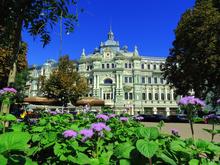
As a part of the Ukrainian Soviet Socialist Republic, the city preserved and somewhat reinforced its unique cosmopolitan mix of Russian/Ukrainian/Jewish culture and a predominantly Russophone environment with the uniquely accented dialect of Russian spoken in the city. The city's unique identity has been formed largely thanks to its varied demography; all the city's communities have influenced aspects of Odesan life in some way or form.
Independence of Ukraine
In the 1991 Ukrainian independence referendum 85.38% of Odesa Oblast voted for independence.[61]
Odesa is a city of more than 1 million people. The city's industries include shipbuilding, oil refining, chemicals, metalworking, and food processing. Odesa is also a Ukrainian naval base and home to a fishing fleet. It is known for its large outdoor market – the Seventh-Kilometer Market, the largest of its kind in Europe.
Odesa was a contender for hosting Euro 2012 football matches in, but lost the competition to other cities in Ukraine.[62]
The city saw violence in the 2014 pro-Russian conflict in Ukraine during the 2014 Odesa clashes. The 2 May 2014 Odesa clashes between pro-Ukrainian and pro-Russian protestors killed 42 people. Four were killed during the protests, and at least 32 trade unionists were killed after a trade union building was set on fire after Molotov cocktails exchange between sides.[63][64] Polls conducted from September to December 2014 found no support for joining Russia.[65]
Odesa was struck by three bomb blasts in December 2014, one of which killed one person (the injuries sustained by the victim indicated that he had dealt with explosives).[66][67] Internal Affairs Ministry advisor Zorian Shkiryak said on 25 December that Odesa and Kharkiv had become "cities which are being used to escalate tensions" in Ukraine. Shkiryak said that he suspected that these cities were singled out because of their "geographic position".[66] On 5 January 2015 the city's Euromaidan Coordination Center and a cargo train car were (non-lethally) bombed.[68]
Until 18 July 2020, Odesa was incorporated as a city of oblast significance. In July 2020, as part of the administrative reform of Ukraine, which reduced the number of raions of Odesa Oblast to seven, the city of Odesa was merged into newly established Odesa Raion.[69][70]
In the 2022 Russian invasion of Ukraine, the city faced some Russian bombing attacks. On 23 April 2022, Russian troops bombarded Odesa with cruise missiles. They destroyed both the city's military infrastructure and residential buildings, killing eight people and wounding another eighteen people.[71][72] In addition, the Russian military destroyed more than 1,000 m2 of the territory of the cemetery.[73] The city suffered further aerial attacks on regional infrastructure facilities in October 2022, cutting off power to 10,500 households and injuring three people.[74]
On 25 January 2023, UNESCO announced that the historical city center of Odesa was added to UNESCO's World Heritage List. In order to provide technical and financial assistance if needed, it was also included into the list of world heritage sites in danger.[75][76]
Geography
Location
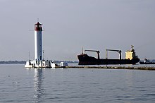
Odesa is located (46°28′N 30°44′E / 46.467°N 30.733°E) in the Black Sea Lowland in Southern Ukraine which being part of the greater Eastern European Plain gradually slopes towards the Black Sea and the Sea of Azov. The city lies on the northwestern coast of the Black Sea along the southwestern shore of the Gulf of Odesa, approximately 31 km (19 mi) north of the estuary of the Dniester river and some 443 km (275 mi) south of the Ukrainian capital Kyiv. The international border between Ukraine and the Republic of Moldova lies some 40 km (25 mi) west of the city.
The city is situated on terraced hills overlooking a small harbor. The average elevation at which the city is located is around 50 metres (160 feet). The maximum is 65 metres (213 feet) and minimum (on the coast) amounts to 4.2 metres (13.8 feet) above sea level. There are three large estuaries near the city: Kuialnyk, Khadzhibey and Sukhyi.
The city currently covers a territory of 162.42 km2 (63 sq mi).[77] The population density for which is around 6,139 persons/km2. Sources of running water in the city include the Dniester River, from which water is taken and then purified at a processing plant just outside the city. Being located in the south of Ukraine, the topography of the area surrounding the city is typically flat and there are no large mountains or hills for many kilometres around. Flora is of the deciduous variety and Odesa is known for its tree-lined avenues which, in the late 19th and early 20th centuries, made the city a favourite year-round retreat for the Russian aristocracy.[citation needed]
The city's location on the coast of the Black Sea has also helped to create a booming tourist industry in Odesa.[citation needed] The city's Arkadia beach has long been a favourite place for relaxation, both for the city's inhabitants and its visitors.[citation needed] This is a large sandy beach which is located to the south of the city centre. Odesa's many sandy beaches are considered to be quite unique in Ukraine,[citation needed] as the country's southern coast (particularly in the Crimea) tends to be a location in which the formation of stoney and pebble beaches has proliferated.
The coastal cliffs adjacent to the city are home to frequent landslides, resulting in a typical change of landscape along the Black Sea. Due to the fluctuating slopes of land, city planners are responsible for monitoring the stability of such areas, and for preserving potentially threatened building and other structures of the city above sea level near water.[78] Also a potential danger to the infrastructure and architecture of the city is the presence of multiple openings underground. These cavities can cause buildings to collapse, resulting in a loss of money and business.[citation needed] Due to the effects of climate and weather on sedimentary rocks beneath the city, the result is instability under some buildings' foundations.
Climate
Odesa has a hot-summer humid continental climate (Dfa, using the 0 °C isotherm), bordering a cold semi-arid (BSk) as well as a humid subtropical climate (Cfa). This has, over the past few centuries, aided the city greatly in creating conditions necessary for the development of summer tourism. During the tsarist era, Odesa's climate was considered to be beneficial for the body, and thus many wealthy but sickly persons were sent to the city in order to relax and recuperate. This resulted in the development of spa culture and the establishment of a number of luxury hotels in the city. The average annual temperature of the sea is 13–14 °C (55–57 °F). Seasonal sea temperatures range from an average of 6 °C (43 °F) from January to March, to 23 °C (73 °F) in August. Typically, for a total of 4 months – from June to September – the average sea temperature in the Gulf of Odesa and the city's bay area exceeds 20 °C (68 °F).[79]
The city typically experiences dry, cold winters which are relatively mild when compared to most of Ukraine, as they are marked by temperatures that rarely fall below −10 °C (14 °F). Summers see an increased level of precipitation, and the city often experiences warm weather with temperatures often reaching the high 20s and low 30s °C. Snow cover is light to moderate due to the city's location on the northern coast of the Black Sea, and municipal services rarely experience problems that can often be found in other, more northern Ukrainian cities. The city hardly ever faces sea ice formation.
| Climate data for Odesa (1991–2020, extremes 1894–present) | |||||||||||||
|---|---|---|---|---|---|---|---|---|---|---|---|---|---|
| Month | Jan | Feb | Mar | Apr | May | Jun | Jul | Aug | Sep | Oct | Nov | Dec | Year |
| Record high °C (°F) | 15.7 (60.3) |
19.2 (66.6) |
24.1 (75.4) |
29.4 (84.9) |
33.3 (91.9) |
37.2 (99.0) |
39.3 (102.7) |
38.0 (100.4) |
35.4 (95.7) |
31.1 (88.0) |
26.0 (78.8) |
16.9 (62.4) |
39.3 (102.7) |
| Mean daily maximum °C (°F) | 2.3 (36.1) |
3.4 (38.1) |
7.7 (45.9) |
13.6 (56.5) |
20.3 (68.5) |
25.1 (77.2) |
27.9 (82.2) |
27.7 (81.9) |
21.8 (71.2) |
15.3 (59.5) |
9.1 (48.4) |
4.2 (39.6) |
14.9 (58.8) |
| Daily mean °C (°F) | −0.4 (31.3) |
0.4 (32.7) |
4.3 (39.7) |
10.0 (50.0) |
16.2 (61.2) |
20.8 (69.4) |
23.4 (74.1) |
23.1 (73.6) |
17.8 (64.0) |
12.0 (53.6) |
6.3 (43.3) |
1.5 (34.7) |
11.3 (52.3) |
| Mean daily minimum °C (°F) | −2.7 (27.1) |
−2.1 (28.2) |
1.6 (34.9) |
6.9 (44.4) |
12.6 (54.7) |
16.9 (62.4) |
19.1 (66.4) |
18.5 (65.3) |
14.0 (57.2) |
8.9 (48.0) |
3.9 (39.0) |
−0.8 (30.6) |
8.1 (46.6) |
| Record low °C (°F) | −26.2 (−15.2) |
−28.0 (−18.4) |
−16.0 (3.2) |
−5.9 (21.4) |
0.3 (32.5) |
5.2 (41.4) |
7.5 (45.5) |
7.9 (46.2) |
−0.8 (30.6) |
−13.3 (8.1) |
−14.6 (5.7) |
−19.6 (−3.3) |
−28.0 (−18.4) |
| Average precipitation mm (inches) | 43 (1.7) |
35 (1.4) |
35 (1.4) |
28 (1.1) |
39 (1.5) |
47 (1.9) |
45 (1.8) |
40 (1.6) |
44 (1.7) |
37 (1.5) |
39 (1.5) |
38 (1.5) |
470 (18.5) |
| Average extreme snow depth cm (inches) | 2 (0.8) |
2 (0.8) |
1 (0.4) |
0 (0) |
0 (0) |
0 (0) |
0 (0) |
0 (0) |
0 (0) |
0 (0) |
0 (0) Zdroj:https://en.wikipedia.org?pojem=Odesa,_Ukraine Text je dostupný za podmienok Creative Commons Attribution/Share-Alike License 3.0 Unported; prípadne za ďalších podmienok. Podrobnejšie informácie nájdete na stránke Podmienky použitia.
Analytika
Antropológia Aplikované vedy Bibliometria Dejiny vedy Encyklopédie Filozofia vedy Forenzné vedy Humanitné vedy Knižničná veda Kryogenika Kryptológia Kulturológia Literárna veda Medzidisciplinárne oblasti Metódy kvantitatívnej analýzy Metavedy Metodika Text je dostupný za podmienok Creative
Commons Attribution/Share-Alike License 3.0 Unported; prípadne za ďalších
podmienok. www.astronomia.sk | www.biologia.sk | www.botanika.sk | www.dejiny.sk | www.economy.sk | www.elektrotechnika.sk | www.estetika.sk | www.farmakologia.sk | www.filozofia.sk | Fyzika | www.futurologia.sk | www.genetika.sk | www.chemia.sk | www.lingvistika.sk | www.politologia.sk | www.psychologia.sk | www.sexuologia.sk | www.sociologia.sk | www.veda.sk I www.zoologia.sk | ||


