A | B | C | D | E | F | G | H | CH | I | J | K | L | M | N | O | P | Q | R | S | T | U | V | W | X | Y | Z | 0 | 1 | 2 | 3 | 4 | 5 | 6 | 7 | 8 | 9
Oakland | |
|---|---|
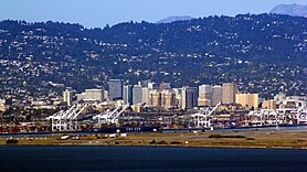
Skyline of Downtown Oakland, with the San Francisco Bay in the background Eastern span of the Bay Bridge | |
| Nickname(s): "Oaktown",[1] "The Town" | |
| Motto: "Love life"[2] | |
 Location in Alameda County and the U.S. state of California | |
| Coordinates: 37°48′16″N 122°16′15″W / 37.80444°N 122.27083°W | |
| Country | United States |
| State | California |
| County | Alameda |
| Incorporated | May 4, 1852[3][4] |
| Named for | The large oak forest that originally covered the area[5] |
| Government | |
| • Type | Strong mayor[6] |
| • Body | Oakland City Council |
| • Mayor | Sheng Thao (D)[7] |
| • Vice Mayor | Rebecca Kaplan (D) |
| • State senator | Nancy Skinner (D)[8] |
| • Assemblymembers | Buffy Wicks (D) and Mia Bonta (D)[9] |
| • U. S. rep. | Barbara Lee (D)[10] |
| Area | |
| • Total | 78.03 sq mi (202.10 km2) |
| • Land | 55.93 sq mi (144.86 km2) |
| • Water | 22.10 sq mi (57.24 km2) |
| Elevation | 43 ft (13 m) |
| Population | |
| • Total | 440,646 |
| • Rank | 1st in Alameda County 8th in California 45th in the United States |
| • Density | 7,878.53/sq mi (3,041.87/km2) |
| Demonym | Oaklander |
| Time zone | UTC−08:00 (PST) |
| • Summer (DST) | UTC−07:00 (PDT) |
| ZIP Codes | 94601–94615, 94617-94624, 94649, 94659–94662, 94666[14] |
| Area codes | 510/341 |
| FIPS code | 06-53000 |
| GNIS feature IDs | 277566, 2411292 |
| Website | www [15][16][17] |
Oakland is the most populous city in and the county seat of Alameda County, California, United States. A major West Coast port, Oakland is the largest city in the East Bay region of the San Francisco Bay Area, and the third-largest city overall in the Bay Area. With a population of 440,646 in 2020,[13] it serves as the Bay Area's trade center: the Port of Oakland is the busiest port in Northern California, and the fifth- or sixth-busiest in the United States.[18] A charter city,[19] Oakland was incorporated on May 4, 1852, in the wake of the state's increasing population due to the California gold rush.[4]
Oakland's territory covers what was once a mosaic of California coastal terrace prairie, oak woodland, and north coastal scrub.[20] In the late 18th century, it became part of a large rancho grant in the colony of New Spain, and known for its plentiful oak tree stands. Its land served as a resource when its hillside oak and redwood timber were logged to build San Francisco.[20] The fertile flatland soils helped it become a prolific agricultural region. In the 1850s, what became the first campus of the University of California was founded in Oakland, and Oakland was selected as the western terminal of the Transcontinental Railroad in 1869.[21] The following year, Oakland's Lake Merritt became the United States' first officially designated wildlife refuge, now a National Historic Landmark. Following the catastrophic 1906 San Francisco earthquake, many San Francisco citizens moved to Oakland, enlarging the population, increasing its housing stock, and improving its infrastructure. It continued to grow in the 20th century with its port, shipyards, and manufacturing industry.
History
Ohlone era
The earliest known inhabitants were the Huchiun natives, who lived there for thousands of years. The Huchiun belonged to a linguistic grouping later called the Ohlone (a Miwok word meaning "western people").[22] In Oakland, they were concentrated around Lake Merritt and Temescal Creek, a stream that enters the San Francisco Bay at Emeryville.
Spanish and Mexican eras
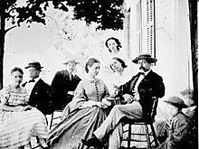
In 1772, the area that later became Oakland was colonized, along with the rest of California, by Spanish settlers for the king of Spain. In the early 19th century, the Spanish crown granted the East Bay area to Luis María Peralta for his Rancho San Antonio. The grant was confirmed by the successor Mexican republic upon its independence from Spain.[23] Upon his death in 1842, Peralta divided his land among his four sons. Most of Oakland was within the shares given to Antonio Maria and Vicente.[24] The portion of the parcel that is now Oakland was called Encinar (misrendered at an early date and carried forward as "encinal") – Spanish for "oak grove" – due to the large oak forest that covered the area, which eventually led to the city's name.[5]
According to Stanford University historian Albert Camarillo, the Peralta family struggled to keep their land after the incorporation of California into the United States after the Mexican–American War. Camarillo claims the family was the victim of targeted racial violence. He writes in Chicanos in California, "They lost everything when squatters cut down their fruit trees, killed their cattle, destroyed their buildings, and even fenced off the roads leading to the rancho. Especially insidious were the actions of attorney Horace Carpentier, who tricked Vicente Peralta into signing a 'lease' which turned out to be a mortgage against the 19,000-acre rancho. The lands became Carpentier's when Peralta refused to repay the loan he believed was fraudulently incurred. The Peraltas had no choice but to abandon the homesite they had occupied for two generations."[25]
City beginnings

In 1851, three men—Horace Carpentier, Edson Adams, and Andrew Moon—began developing what is now downtown Oakland.[26] In 1852, the Town of Oakland was incorporated by the state legislature.[27] During this time, Oakland had 75–100 inhabitants, two hotels, a wharf, two warehouses, and only cattle trails. Two years later, on March 25, 1854, Oakland re-incorporated as the City of Oakland.[28] Horace Carpentier was elected the first mayor, though a scandal ended his mayorship in less than a year.[citation needed] In 1853, a preparatory academy was founded in Oakland that soon became the College of California, and in 1869, the first campus of the University of California, the university moved just north to Berkeley in the 1870s.[29]
During the 1850s, just as gold was discovered in California, Oakland started growing and further developing because land was becoming too expensive in San Francisco.[30] People in China were struggling financially as a result of the First Opium War, the Second Opium War, and the Taiping Rebellion, so they began migrating to Oakland, many of whom were recruited to work on railroads. However, the Chinese struggled to settle because they were discriminated against by the white community and their living quarters were burned down on several occasions.[31][page needed]
The city and its environs quickly grew with the railroads, becoming a major rail terminal in the late 1860s and 1870s. In 1868, the Central Pacific constructed the Oakland Long Wharf at Oakland Point, the site of today's Port of Oakland.[32]
A number of horsecar and cable car lines were constructed in Oakland during the latter half of the 19th century. The first electric streetcar set out from Oakland to Berkeley in 1891, and other lines were converted and added over the course of the 1890s. The various streetcar companies operating in Oakland were acquired by Francis "Borax" Smith and consolidated into what eventually became known as the Key System, the predecessor of today's publicly owned AC Transit.
1900–1950s
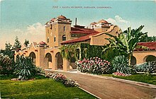
Oakland was one of the worst affected cities in California that was impacted by the San Francisco plague of 1900–1904. Quarantine measures were set in place at the Oakland ports requiring the authorities at the port to inspect the arriving vessels for the presence of infected rats.[33] Quarantine authorities at these ports inspected over a thousand vessels per year for plague and yellow fever. By 1908, over 5,000 people were detained in quarantine.[34] Hunters were sent to poison the affected areas in Oakland and shoot the squirrels, but the eradication work was limited in its range because the State Board of Health and the United States Public Health Service were only allotted about $60,000 a year to eradicate the disease. During this period Oakland did not have sufficient health facilities, so some of the infected patients were treated at home.[35]
The State Board of Health along with Oakland also advised physicians to promptly report any cases of infected patients.[36] Yet, in 1919 it still resulted in a small epidemic of Pneumonic plague which killed a dozen people in Oakland.[36] This started when a man went hunting in Contra Costa Valley and killed a squirrel. After eating the squirrel, he fell ill four days later and another household member contracted the plague. This in turn was passed on either directly or indirectly to about a dozen others.[37] The officials in Oakland acted quickly by issuing death certificates to monitor the spread of plague.[36]
Incorporation

At the time of incorporation in 1852, Oakland had consisted of the territory that lay south of today's major intersection of San Pablo Avenue, Broadway, and Fourteenth Street. The city gradually annexed farmlands and settlements to the east and the north. Oakland's rise to industrial prominence, and its subsequent need for a seaport, led to the digging of a shipping and tidal channel in 1902. This resulted in the nearby town of Alameda being made an island. In 1906, the city's population doubled with refugees made homeless after the 1906 San Francisco earthquake and fire.
In 1908, the lawyer, former miner, and newspaper owner Homer Wood (1880–1976) suggested to his friend Frank Bilger of Blake and Bilger Rock Quarry and Paving Company that he organize a gathering to establish a Rotary Club east of the bay. On November 27, 1908, Homer took a ferry across the bay in a driving rainstorm and met for lunch with Frank and twenty three other businessmen at the Hotel Metropole at 13th and Jefferson. This gathering became the first meeting of the Tri-City Rotary Club, renamed in 1911 The Rotary Club of Oakland, the third Rotary Club in the world. This group established the tradition of weekly meetings, something most clubs worldwide follow today.[38]
In 1917, General Motors opened an automobile factory in East Oakland called Oakland Assembly. It produced Chevrolet cars and then GMC trucks until 1963, when it was moved to Fremont in southern Alameda County.[39] Also in 1916, the Fageol Motor Company chose East Oakland for their first factory, manufacturing farming tractors from 1918 to 1923.[40][41] By 1920, Oakland was the home of numerous manufacturing industries, including metals, canneries, bakeries, internal combustion engines, automobiles, and shipbuilding.[42] By 1929, when Chrysler expanded with a new plant there, Oakland had become known as the "Detroit of the West," referring to the major auto manufacturing center in Michigan.[43]
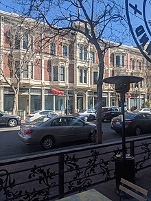
Oakland expanded during the 1920s, as its population expanded with factory workers. Approximately 13,000 homes were built in the 3 years between 1921 and 1924,[44] more than during the 13 years between 1907 and 1920.[45] Many of the large downtown office buildings, apartment buildings, and single-family houses still standing in Oakland were built during the 1920s; they reflect the architectural styles of the time.
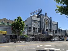

Russell Clifford Durant established Durant Field at 82nd Avenue and East 14th Street in 1916.[46] The first transcontinental airmail flight finished its journey at Durant Field on August 9, 1920, flown by Army Capt. Eddie Rickenbacker and Navy Lt. Bert Acosta.[47] Durant Field was often called Oakland Airport, though the current Oakland International Airport was soon established four miles (6.4 km) to the southwest.[48]
During World War II, the East Bay Area was home to many war-related industries. Oakland's Moore Dry Dock Company expanded its shipbuilding capabilities and built over 100 ships. Valued at $100 million in 1943, Oakland's canning industry was its second-most-valuable war contribution after shipbuilding. The largest canneries were in the Fruitvale District, and included the Josiah Lusk Canning Company, the Oakland Preserving Company (which started the Del Monte brand), and the California Packing Company.[49]
President Franklin D. Roosevelt called on defense industries with government contracts to integrate their workforces and provide opportunities for all Americans. Tens of thousands of laborers came from around the country, especially poor whites and blacks from the Deep South: Alabama, Arkansas, Georgia, Louisiana, Mississippi, South Carolina, and Texas, as well as Missouri and Tennessee. Henry J. Kaiser's representatives recruited sharecroppers and tenant farmers from rural areas to work in his shipyards. African Americans were part of the Great Migration by which five million persons left the South, mostly for the West, from 1940 to 1970. White migrants from the Jim Crow South carried their racial attitudes, causing tensions to rise among black and white workers competing for the better-paying jobs in the Bay Area. The racial harmony Oakland African-Americans had been accustomed to prior to the war evaporated.[50] Also migrating to the area during this time were many Mexican Americans from southwestern states such as New Mexico, Texas, and Colorado. Many worked for the Southern Pacific Railroad, at its major rail yard in West Oakland. Their young men encountered hostility and discrimination by Armed Forces personnel, and tensions broke out in "zoot suit riots" in downtown Oakland in 1943 in the wake of a major disturbance in Los Angeles that year.[51]
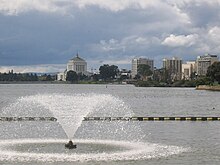
In 1946, National City Lines (NCL), a General Motors holding company, acquired 64% of Key System stock; during the next several years NCL engaged in the conspiratorial dissolution of Oakland's electric streetcar system. The city's expensive electric streetcar fleet was converted to the cheaper diesel buses.[52] The state Legislature created the Alameda and Contra Costa Transit District in 1955, which operates today as AC Transit, the third-largest bus-only transit system in the nation.[53]
After the war, as Oakland's shipbuilding industry declined and the automobile industry went through restructuring, many jobs were lost.[citation needed] In addition, labor unrest increased as workers struggled to protect their livelihoods. Oakland was the center of a general strike during the first week of December 1946, one of six cities across the country that had such a strike after World War II.[54]
The Mary's First and Last Chance in Oakland was a lesbian bar, once the focus of the 1950s California Supreme Court lawsuit Vallerga v. Dept. Alcoholic Bev. Control, when the bar challenged a state law for the right to serve gay patrons and won in 1959.[55][56]
1960–1999
In 1960, Kaiser Corporation opened its new headquarters; it was the largest skyscraper in Oakland, as well as "the largest office tower west of Chicago" up to that time.[57] In the postwar period, suburban development increased around Oakland, and wealthier residents moved to new housing. Despite the major increases in the number and proportion of African Americans in the city, in 1966 only 16 of the city's 661 police officers were black. Tensions between the black community and the largely white police force were high, as expectations during the civil rights era increased to gain social justice and equality before the law. Police abuse of blacks was common.[58][59]
Students Huey Newton and Bobby Seale founded the Black Panther Party at Merritt College (then located at a former high school on Grove Street, now occupied by Children's Hospital Oakland Research Institute), which emphasized Black nationalism, advocated armed self-defense against police, and was involved in several incidents that ended in the deaths of police officers and other Black Panther members. Among their social programs were feeding children and providing other services to the needy.[60]
As in many other American cities during the 1980s, crack cocaine became a serious problem in Oakland. Drug dealing in general, and the dealing of crack cocaine in particular, resulted in elevated rates of violent crime, causing Oakland to consistently be listed as one of America's most crime-ridden cities.[61]
In 1980, Oakland's Black population reached its 20th-century peak at approximately 47% of the overall city population.[62]
The 6.9 Mw Loma Prieta earthquake occurred on October 17, 1989. The rupture was related to the San Andreas fault system and affected the entire San Francisco Bay Area with a maximum Mercalli intensity of IX (Violent). Many structures in Oakland were badly damaged including the double-decker portion of Interstate 880 that collapsed. The eastern span of the San Francisco–Oakland Bay Bridge also sustained damage and was closed to traffic for one month.
On October 20, 1991, a massive firestorm swept down from the Berkeley/Oakland hills above the Caldecott Tunnel. Twenty-five people were killed, 150 people were injured, and nearly 4,000 homes destroyed. With the loss of life and an estimated economic loss of US$1.5 billion, this was the worst urban firestorm in American history, until 2017.[63][64]
During the mid-1990s, Oakland's economy began to recover as it transitioned to new types of jobs. In addition, the city participated in large development and urban renewal projects, concentrated especially in the downtown area, at the Port of Oakland, and at the Oakland International Airport.[65]
21st century
After his 1999 inauguration, Oakland Mayor Jerry Brown continued his predecessor Elihu Harris' public policy of supporting downtown housing development in the area defined as the Central Business District in Oakland's 1998 General Plan.[66] Brown's plan and other redevelopment projects were controversial due to potential rent increases and gentrification, which would displace lower-income residents from downtown Oakland into outlying neighborhoods and cities.[67]
Due to allegations of misconduct by the Oakland Police Department, the City of Oakland has paid claims for a total of US$57 million during the 2001–2011 timeframe to plaintiffs claiming police abuse; this is the largest sum paid by any city in California.[68] On October 10, 2011, protesters and civic activists began "Occupy Oakland" demonstrations at Frank Ogawa Plaza in Downtown Oakland.[69][70]
African-Americans dropped to 28% of Oakland's population in 2010, from nearly half in 1980, due to fast-rising rents and an extreme housing crisis in the region.[71]
The city inspected warehouses and live/work spaces after a fire broke out in the Ghost Ship warehouse, killing 36 people in 2016.[72]
Oakland is the second U.S. city, after Denver, to decriminalize psilocybin mushrooms. In June 2019, the City Council passed the resolution in a unanimous vote ending the investigation and imposition of criminal penalties for use and possession of natural entheogens.[73][74]
In November 2019, two homeless mothers and their children moved into a vacant three-bedroom house in West Oakland. The group, calling themselves Moms 4 Housing, said their goal was to protest what they said was a large number of vacant houses in Oakland owned by redevelopment companies while the city experienced a housing crisis.[75] Two months later they were evicted from the house by three dozen sheriff's deputies, as hundreds of supporters demonstrated in favor of the women.[76] The incident received nationwide coverage.[77] The company that owns the house later said they would sell it to a nonprofit affordable housing group.[78] As of 2019, Oakland's per-capita homeless rate was higher than San Francisco and Berkeley. Between 2014 and 2020, Oakland strengthened its protections for tenants in order to reduce the displacement of its long-time residents. Between January 2020 and March 2022, Oakland suffered a disproportionate death toll from the COVID-19 pandemic and Deltacron hybrid variant within the San Francisco Bay Area.
In 2023, prior to and during the Covid pandemic, Oakland became the first city in American history to lose three professional major league sports teams to other cities within a span of five years.[79]
Geography
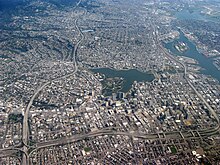

Oakland is in the eastern region of the San Francisco Bay.
The United States Census Bureau says the city's total area is 78.0 square miles (202 km2), including 55.8 square miles (145 km2) of land and 22.2 square miles (57 km2) (28.48 percent) of water.
Oakland's highest point is near Grizzly Peak Blvd, east of Berkeley, just over 1,760 feet (540 m) above sea level at about 37°52′43″N 122°13′27″W / 37.8786°N 122.2241°W. Oakland has 19 miles (31 km) of shoreline,[80] but Radio Beach is the only beach in Oakland.
Oaklanders refer to their city's terrain as "the flatlands" and "the hills". Until recent waves of gentrification, these terms also symbolized Oakland's deep economic divide, with "the hills" being more affluent communities. About two-thirds of Oakland lies in the flat plain of the East Bay, with one-third rising into the foothills and hills of the East Bay range.
Ruptures along the nearby San Andreas Fault caused severe earth movement in the San Francisco Bay Area in 1906 and 1989. San Andreas quakes induces creep (movement occurring on earthquake faults) in the Hayward fault, which runs directly through Oakland, Berkeley, San Jose and other Bay Area cities.[81]
Neighborhoods

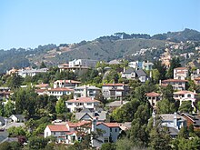
Oakland has more than 50 distinct neighborhoods. The city's greater divisions include downtown Oakland and its greater Central Business District, Lake Merritt, East Oakland, North Oakland, West Oakland, and the Oakland Hills. East Oakland, which includes the East Oakland Hills, encompasses more than half of Oakland's land area, stretching from Lakeshore Avenue on the east shore of Lake Merritt southeast to the San Leandro border. North Oakland encompasses the neighborhoods between downtown and Berkeley and Emeryville. West Oakland is the area between downtown and the Bay, partially surrounded by the Oakland Point, and encompassing the Port of Oakland. In 2011, Oakland was ranked the tenth most walkable city in the United States by Walk Score.[82]
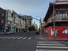
Lake Merritt, an urban estuary near downtown, is a mix of fresh and salt water draining in and out from the Oakland Harbor at the San Francisco Bay and one of Oakland's most notable features.[83] It was designated the United States' first official wildlife refuge in 1870.[84] Originally a marsh-lined wildlife haven, Lake Merritt was dredged and bordered with parks from the 1890s to the 1910s. Despite this reduction in habitat, Oakland is home to a number of rare and endangered species, many of which are localized to serpentine soils and bedrock. Lake Merritt is surrounded by residential and business districts, including downtown and Grand Lake.
The city of Piedmont, incorporated in Oakland's central foothills after the 1906 earthquake, is a small independent city surrounded by the city of Oakland.
Climate
Oakland has a warm-summer Mediterranean climate (Köppen Csb) with an average of 260 sunny days per year. In general, the city features warm, dry summers, and cool, wet winters.
Based on data gathered by the National Oceanic and Atmospheric Administration, Oakland is ranked No. 1 in climate among U.S. cities.[85] Oakland's climate is typified by the temperate and seasonal Mediterranean climate. Summers are usually dry and warm and winters are cool and damp. It has features found in both nearby coastal cities such as San Francisco and inland cities such as San Jose, making it warmer than San Francisco and cooler than San Jose. Its position on San Francisco Bay across from the Bay Bridge means the northern part of the city can have cooling maritime fog. It is far enough inland that the fog often burns off by midday, allowing it to have typically sunny California days. The hills tend to have more fog than the flatlands, as the fog drifts down from Berkeley.
The U.S. Weather Bureau kept weather records in downtown Oakland from October 4, 1894, to July 31, 1958. During that time, the record high temperature was 104 °F (40 °C) on June 24, 1957, and the record low temperature was 24 °F (−4 °C) on January 23, 1949. Dry, warm offshore "Diablo" winds (similar to the Santa Ana winds of Southern California) sometimes occur, especially in fall, and raise the fire danger. In 1991, such an episode allowed the catastrophic Oakland Hills fire to spread and consume many homes.
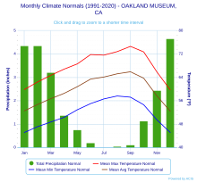
Oakland, like much of Northern California, is susceptible to winter rainstorms and Atmospheric rivers. The wettest “rain year” was from July 1997 to June 1998 with 47.76 inches (1,213.1 mm) and the driest from July 2019 to June 2020 with 9.28 inches (235.7 mm). The most rainfall in one month was 15.35 inches (390 mm) in January 1911. The most rainfall in 24 hours was 4.29 inches (109 mm) on January 26, 2008.[86] Rainfall near the bayfront is only 23 inches (580 mm), but is higher in the Oakland Hills to the east (up to 30 inches ), with nearly all precipitation falling between November and April.
Overnight lows are mild. Oakland seldom experiences warm nights with the warmest recorded night of 72 °F (22 °C) in September 1971 and an average of 64 °F (18 °C) for the annual warmest low.[87] The coldest day of the year averages a mild 50 °F (10 °C) and has never been recorded below 36 °F (2 °C).[87]
The National Weather Service today has two official weather stations in Oakland: Oakland International Airport and the Oakland Museum (established 1970).
| Climate data for Oakland, California (1991–2020 normals, extremes 1970–present) | |||||||||||||
|---|---|---|---|---|---|---|---|---|---|---|---|---|---|
| Month | Jan | Feb | Mar | Apr | May | Jun | Jul | Aug | Sep | Oct | Nov | Dec | Year |
| Record high °F (°C) | 78 (26) |
82 (28) |
88 (31) |
97 (36) |
105 (41) |
106 (41) |
103 (39) |
100 (38) |
109 (43) |
103 (39) |
84 (29) |
75 (24) |
109 (43) |
| Mean maximum °F (°C) | 68.6 (20.3) |
72.5 (22.5) |
76.7 (24.8) |
82.2 (27.9) |
84.2 (29.0) |
88.7 (31.5) |
86.0 (30.0) |
87.5 (30.8) |
90.6 (32.6) |
87.7 (30.9) |
77.1 (25.1) |
68.0 (20.0) |
92.6 (33.7) |
| Mean daily maximum °F (°C) | 59.8 (15.4) |
62.4 (16.9) |
64.7 (18.2) |
66.8 (19.3) |
68.6 (20.3) |
71.8 (22.1) |
71.6 (22.0) |
72.8 (22.7) |
74.6 (23.7) |
72.7 (22.6) |
65.8 (18.8) |
59.7 (15.4) |
67.6 (19.8) |
| Daily mean °F (°C) | 52.5 (11.4) |
54.7 (12.6) |
56.7 (13.7) |
58.5 (14.7) |
60.8 (16.0) |
63.4 (17.4) |
64.1 (17.8) |
65.2 (18.4) |
65.9 (18.8) |
63.7 (17.6) |
57.6 (14.2) |
52.4 (11.3) |
59.6 (15.3) |
| Mean daily minimum °F (°C) | 45.1 (7.3) |
47.1 (8.4) |
Zdroj:https://en.wikipedia.org?pojem=Oakland,_CA|||||||||||


