

A | B | C | D | E | F | G | H | CH | I | J | K | L | M | N | O | P | Q | R | S | T | U | V | W | X | Y | Z | 0 | 1 | 2 | 3 | 4 | 5 | 6 | 7 | 8 | 9
Republic of North Ossetia–Alania | |
|---|---|
| Республика Северная Осетия — Алания | |
| Other transcription(s) | |
| • Ossetic | Республикӕ Цӕгат Ирыстон/Иристон — Алани |
| Anthem: State Anthem of the Republic of North Ossetia–Alania[3] | |
.svg) | |
| Coordinates: 43°11′N 44°14′E / 43.183°N 44.233°E | |
| Country | Russia |
| Federal district | North Caucasian[1] |
| Economic region | North Caucasus[2] |
| Capital | Vladikavkaz[4] |
| Government | |
| • Body | Parliament[5] |
| • Head[5] | Sergey Menyaylo[6] |
| Area | |
| • Total | 7,987 km2 (3,084 sq mi) |
| • Rank | 79th |
| Population | |
| • Total | 687,357 |
| • Estimate (2018)[9] | 701,765 |
| • Rank | 63rd |
| • Urban | 63.8% |
| • Rural | 36.2% |
| Time zone | UTC+3 (MSK |
| ISO 3166 code | RU-SE |
| License plates | 15 |
| OKTMO ID | 90000000 |
| Official languages | Russian;[11] Ossetic[12] |
| Website | www |


North Ossetia (Russian: Северная Осетия, romanized: Severnaya Osetiya; Ossetian: Цæгат Ирыстон/Иристон, romanized: Cægat Iryston/Iriston), officially the Republic of North Ossetia–Alania,[a] is a republic of Russia situated in the North Caucasus of Eastern Europe. It borders the country of Georgia to the south, and the Russian federal subjects of Kabardino-Balkaria to the west, Stavropol Krai to the north, Chechnya to the east and Ingushetia to the southeast. Its population according to the 2021 Census was 687,357.[8] The republic’s capital city is Vladikavkaz, located on the foothills of the Caucasus Mountains.
The majority of the republic's population (68.1% as of 2021) are Ossetians, an Iranian ethnic group native to the republic and neighboring South Ossetia.[14] Ossetian is an east Iranian language descended from the medieval Alanic and ancient Sarmatian languages.[15] Unlike many ethnic groups in the North Caucasus, the majority of Ossetians are Christians, predominantly Eastern Orthodox. Almost 30% of the population adheres to Ossetian ethnic religion, generally called Uatsdin (Уацдин, "True Faith"), and there is a sizable Muslim minority.[16] Ethnic Russians and Ingush, who form a majority in neighboring Ingushetia, form substantial minorities in the republic.[14]
The Ossetia region traces its history back to the ancient Alans, who founded the Kingdom of Alania in the 8th century and adopted Christianity in the 9th century. The kingdom would fall to the Mongols in the 13th century. From 1774 to 1806, Ossetia was slowly incorporated into the Russian Empire, which would split the region into a northern part included in the Terek Oblast, and a southern one included in the Tiflis and Kutaisi governorates. This partition would persist in the Soviet period, where North Ossetia was made into the Mountain Autonomous Soviet Socialist Republic within the Russian SFSR, while South Ossetia became an autonomous oblast within the Georgian SSR.[17]
Following the dissolution of the Soviet Union, the republic experienced internal conflict like in much of the North Caucasus. In 1992, a brief ethnic war between Ossetians and the predominantly Muslim Ingush population in the Prigorodny District took place. The republic has experienced spillover from the Chechen conflict, most notably in the form of the 2004 Beslan school siege.[18] Proposals for Russia to annex South Ossetia in order to incorporate the two as one entity exist to this day.
Ossetian cuisine is distinguished as an integral aspect of Ossetian culture. Ossetian-style pies such as Fydzhin (a meat pie) are a quintessential component of Ossetian cuisine. The "three pies" concept holds special symbolic significance, and representing the Sun, Earth, and water.[19]
Name
In the last years of the Soviet Union, as nationalist movements swept throughout the Caucasus, many intellectuals in the North Ossetian ASSR called for the revival of the name of Alania, a medieval kingdom of the Alans.
The term "Alania" quickly became popular in Ossetian daily life through the names of various enterprises, TV channels, political and civic organizations, publishing house, football team, etc. In November 1994, the name "Alania" was officially added to the republic’s title (Republic of North Ossetia–Alania).[20]
Geography
The republic is located in the North Caucasus. The northern part of the republic is situated in the Stavropol Plain. 22% of the republic’s territory is covered by forests.
- Area: 8,000 square kilometers (3,100 sq mi)
- Borders:
- internal: Kabardino-Balkaria (W/NW/N), Stavropol Krai (N), Chechnya (NE/E), Ingushetia (E/SE)
- international: Georgia (including South Ossetia; Mtskheta-Mtianeti, Racha-Lechkhumi and Kvemo Svaneti and Shida Kartli) (SE/S/SW)
- Highest point: Mount Kazbek (5,033 meters (16,512 ft))
- Maximum north–south distance: 130 kilometers (81 mi)
- Maximum east–west distance: 120 kilometers (75 mi)
Rivers
All of the republic’s rivers belong to the drainage basin of the Terek River. Major rivers include:
- Terek River (~600 km)
- Urukh River (104 km)
- Ardon River (101 km)
- Kambileyevka River (99 km)
- Gizeldon River (81 km)
- Fiagdon River
- Sunzha River (278 km)
Mountains
_5033_m.,_Stefancminda_district.jpg)
All of the mountains located on the territory of the republic are a part of the Caucasus. Mount Kazbek is the highest point (5,033 m), with Mount Jimara being the second-highest (4,780 m).
Natural resources
Natural resources include minerals (copper, silver, zinc), timber, mineral waters, hydroelectric power, and untapped reserves of oil and gas.
Climate
The climate is moderately continental.
- Average January temperature: −5 °C (23 °F)
- Average July temperature: +24 °C (75 °F)
- Average annual precipitation: 400–700 millimeters (16–28 in) in the plains; over 1,000 millimeters (39 in) in the mountains.
History
This article needs additional citations for verification. (November 2017) |


Early history: Kingdom of Alania and Middle Ages
The territory of North Ossetia was first inhabited by Caucasian tribes. Some Nomadic Alans settled in the region in the 7th century, forming the Kingdom of Alania. It was eventually converted to Christianity by missionaries from Byzantium.
Alania greatly profited from the Silk Road which passed through its territory.
After the Middle Ages, the Mongols’ and Tartars’ repeated invasions decimated the population, now known as the Ossetians. Islam was introduced to the region in the 17th century by Kabardians.
Russian imperial rule (1806–1917)
Conflicts between the Khanate of Crimea and the Ottoman Empire eventually pushed Ossetia into an alliance with Imperial Russia in the 18th century. Soon, Russia established a military base in the capital, Vladikavkaz, making it the first Russian-controlled area in the northern Caucasus. By 1806, Ossetia was under complete Russian control.
The Russians’ rule led to rapid development of industry and railways which overcame its isolation. The first books from the area came during the late 18th century, and became part of the Terskaya Region of Russia in the mid-19th century.
Soviet period (1917–1990)
.png)
The Russian Revolution of 1917 resulted in North Ossetia being merged into the Mountain Autonomous Soviet Socialist Republic in 1921. It then became the North Ossetian Autonomous Oblast on 7 July 1924, then merged into the North Ossetian Autonomous Soviet Socialist Republic on 5 December 1936. In World War II, it was subject to a number of attacks by Nazi German invaders unsuccessfully trying to seize Vladikavkaz in 1942.
The North Ossetian ASSR declared itself the autonomous republic of the Soviet Union on 20 June 1990. Its name was changed to the Republic of North Ossetia–Alania in 1994.
Russian Federation period (1990–present)
The dissolution of the Soviet Union posed particular problems for the Ossetian people, who were divided between North Ossetia, which was part of the Russian SFSR, and South Ossetia, part of the Georgian SSR. In December 1990, the Supreme Soviet of the Georgian SSR abolished the autonomous Ossetian enclave amid the rising ethnic tensions in the region, which was further fanned by Moscow; a lot of the conflict zone population, faced with the ethnic cleansing, was forced to flee across the border to either North Ossetia or Georgia proper.
As a result, some 70,000 South Ossetian refugees were resettled in North Ossetia. Additionally, North Ossetia provoked the predominantly Ingush population in the Prigorodny District, which sparked the Ossetian–Ingush conflict. The results of the conflict were that 7,000 Ossetians and 64,000 Ingush refugees had to flee their homes.[22] On 23 March 1995, North Ossetia–Alania signed a power-sharing agreement with the federal government, granting it autonomy.[23] However, this agreement was abolished on 2 September 2002.[24]
Following the de facto independence of South Ossetia, there have been proposals in this state of joining Russia and uniting with North Ossetia. As well as dealing with the effects of the conflict in South Ossetia, North Ossetia has had to deal with refugees and the occasional spillover of fighting from the wars around them. This notably manifested in the form of the 2004 Beslan school siege by Chechen terrorists.[18]
Administrative divisions

Economy
In recent years, North Ossetia–Alania’s economic development has been successful; the indicators of the republic’s social and economic development between 2005 and 2007 revealed a stable growth of all sectors of the economy and major social parameters. The nature and climatic conditions of the republic contribute to the successful development of various economic sectors, which is compounded by the abundance of natural resources. Gross regional product pro capita of the region in 2006 was 61,000 rubles ($2,596) and increased 30% in the 2005–2007 time period.[25] GRP pro capita in 2007 was 76,455 rubles.[26] From 2005 to 2007, the average monthly wage in North Ossetia–Alania doubled, with the actual cash earnings increased by 42.5 percent. In terms of the average monthly wage growth, the Republic ranks first in the North Caucasus.[25]
The regional government’s economic priorities include industrial growth, development of small enterprise, spas, and resorts, and strengthening the budgetary and tax discipline.[27]
The largest companies in the region include Elektrozinc, Sevkavkazenergo, Pobedit (tungsten and molybdenum producer).[28]

Natural resources, agriculture, and industry

The most widespread resources are zinc- and lead-containing complex ores. There are deposits of limestone, dolomites, marble, and touchstone. There is also a large availability of construction materials, such as clay, sand, and gravel. The local oil deposit reserves are estimated at 10 million metric tons.[25]
The agricultural sector is varied and specializes in the cultivation of wheat, corn, and sunflowers; horticulture; viticulture; and cattle and sheep breeding.[29][30]
North Ossetia’s industry is mainly concentrated in Vladikavkaz. Major companies located here include Elektrotsink, Gazoapparat, an instrument-making plant, Elektrokontraktor, a factory producing automotive electrical equipment, a large-panel construction complex, and companies in the food industry. The Sadonsky industrial center has grown around the mining and forest industries.[30]
Tourism


Despite the proximity to Chechnya, North Ossetia is making efforts to develop its tourist industry.[31] Projects under a program for spa, resort, and tourism development have been successfully implemented in the mountainous part of the republic, according to the head of the regional government.[27] There are nearly 3,000 historical monuments in the Republic and more than half of its area is occupied by Alania National Park, the North Ossetia National Preserve, and game preserves.
There are more than 250 therapeutic, mineral, and freshwater springs in the republic with estimated daily reserves of 15,000 cubic meters. Besides providing the basis for health spas, these mineral waters also have the potential to be bottled and sold. North Ossetian mineral waters are known for their unique qualities, as well as special mineral composition.[30][31]
Infrastructure
In terms of its infrastructure, North Ossetia–Alania ranks second in the Southern Federal District and 10th in the nation.[25] The republic has some of the most extensive telecommunication networks in the North Caucasus region and in Russia. It ranks first in terms of its telecom network installations in the Southern Federal District.
The republic ranks fourth in Russia in terms of its paved roads, and its expanding transport and logistics complex provides communication networks between Russia and the South Caucasus, as well as Central Asia. The complex includes two federal highways (Georgian Military Road connects Vladikavkaz with Transcaucasia) running across the Greater Caucasus Range, two customs checkpoints for cars, a developed railway network, Vladikavkaz international airport, and well-equipped transport terminals.[25]
Demographics
Population: 687,357 (2021 Census);[32] 712,980 (2010 Russian census);[14] 710,275 (2002 Census);[33] 634,009 (1989 Soviet census).[34]
| Year | Pop. | ±% |
|---|---|---|
| 1926 | 226,033 | — |
| 1959 | 450,581 | +99.3% |
| 1970 | 552,581 | +22.6% |
| 1979 | 596,921 | +8.0% |
| 1989 | 634,009 | +6.2% |
| 2002 | 710,275 | +12.0% |
| 2010 | 712,980 | +0.4% |
| 2021 | 687,357 | −3.6% |
| Source: Census data | ||
Number of refugees: 12,570[35]
| 2019 | 2021 | |
|---|---|---|
| Average: | 75.8 years | 72.5 years |
| Male: | 70.5 years | 68.1 years |
| Female: | 80.6 years | 76.5 years |
-

-
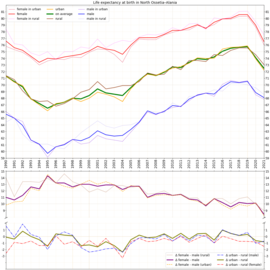 Life expectancy with calculated differences
 -
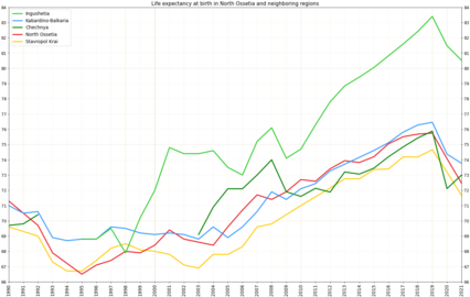 Life expectancy in North Ossetia in comparison with neighboring regions of the country


Settlements
Largest cities or towns in North Ossetia–Alania
2023 Estimation of Rosstat | |||||||||
|---|---|---|---|---|---|---|---|---|---|
| Rank | Administrative Division | Municipal pop. | |||||||
 Vladikavkaz  Mozdok |
1 | Vladikavkaz | City of republic significance of Vladikavkaz | 292,886 | |||||
| 2 | Mozdok | Mozdoksky District | 35,662 | ||||||
| 3 | Beslan | Pravoberezhny District | 36,011 | ||||||
| 4 | Alagir | Alagirsky District | 21,315 | ||||||
| 5 | Ardon | Ardonsky District | 18,915 | ||||||
| 6 | Elkhotovo | Kirovsky District | 12,690 | ||||||
| 7 | Sunzha | Prigorodny District | 11,068 | ||||||
| 8 | Nogir | Prigorodny District | 11,947 | ||||||
| 9 | Digora | Digorsky District | 9,994 | ||||||
| 10 | Kizlyar | Mozdoksky District | 10,970 | ||||||
Vital statistics
| [38] | Average population (per 1000) | Live births | Deaths | Natural change | Crude birth rate (per 1000) | Crude death rate (per 1000) | Natural change (per 1000) | Fertility rates |
|---|---|---|---|---|---|---|---|---|
| 1970 | 554 | 9,731 | 3,964 | 5,767 | 17.6 | 7.2 | 10.4 | |
| 1975 | 575 | 10,368 | 4,664 | 5,704 | 18.0 | 8.1 | 9.9 | |
| 1980 | 598 | 10,135 | 5,821 | 4,314 | 16.9 | 9.7 | 7.2 | |
| 1985 | 617 | 11,598 | 6,047 | 5,551 | 18.8 | 9.8 | 9.0 | |
| 1990 | 649 | 10,967 | 6,166 | 4,801 | 16.9 | 9.5 | 7.4 | 2.23 |
| 1991 | 679 | 10,985 | 6,694 | 4,291 | 16.2 | 9.9 | 6.3 | 2.09 |
| 1992 | 683 | 10,048 | 7,125 | 2,923 | 14.7 | 10.4 | 4.3 | 1.89 |
| 1993 | 661 | 8,251 | 7,872 | 379 | 12.5 | 11.9 | 0.6 | 1.67 |
| 1994 | 666 | 8,806 | 8,329 | 477 | 13.2 | 12.5 | 0.7 | 1.79 |
| 1995 | 674 | 8,781 | 8,574 | 207 | 13.0 | 12.7 | 0.3 | 1.78 |
| 1996 | 680 | 8,043 | 8,514 | −471 | Zdroj:https://en.wikipedia.org?pojem=North_Ossetia-Alania