

A | B | C | D | E | F | G | H | CH | I | J | K | L | M | N | O | P | Q | R | S | T | U | V | W | X | Y | Z | 0 | 1 | 2 | 3 | 4 | 5 | 6 | 7 | 8 | 9
Northeast India | |
|---|---|
| North Eastern Region (NER) | |
From top, left to right: Sela Pass, Loktak Lake, Kolodyne castle, Unakoti stone relief, Kaziranga National Park, Umngot River, Dzukou Valley, Kangchenjunga | |
 | |
 | |
| Coordinates: 26°N 91°E / 26°N 91°E | |
| Country | |
| States | |
| Largest city | Guwahati |
| Major cities (2011 Census of India)[1] | |
| Area | |
| • Total | 262,184 km2 (101,230 sq mi) |
| Population (2011) | |
| • Total | 45,772,188 |
| • Estimate (2022)[2] | 51,670,000 |
| • Density | 173/km2 (450/sq mi) |
| Time zone | UTC+5:30 (Indian Standard Time) |
| Scheduled languages | |
| State/Regional official languages |
|


.JPG)


Northeast India, officially the North Eastern Region (NER), is the easternmost region of India representing both a geographic and political administrative division of the country.[18] It comprises eight states—Arunachal Pradesh, Assam, Manipur, Meghalaya, Mizoram, Nagaland and Tripura (commonly known as the "Seven Sisters"), and the "brother" state of Sikkim.[19]
The region shares an international border of 5,182 kilometres (3,220 mi) (about 99 per cent of its total geographical boundary) with several neighbouring countries – 1,395 kilometres (867 mi) with China in the north, 1,640 kilometres (1,020 mi) with Myanmar in the east, 1,596 kilometres (992 mi) with Bangladesh in the south-west, 97 kilometres (60 mi) with Nepal in the west, and 455 kilometres (283 mi) with Bhutan in the north-west.[20] It comprises an area of 262,184 square kilometres (101,230 sq mi), almost 8 per cent of that of India. The Siliguri Corridor connects the region to the rest of mainland India.
The states of North Eastern Region are officially recognised under the North Eastern Council (NEC),[19] constituted in 1971 as the acting agency for the development of the north eastern states. Long after induction of NEC, Sikkim formed part of the North Eastern Region as the eighth state in 2002.[21][22] India's Look-East connectivity projects connect Northeast India to East Asia and ASEAN. The city of Guwahati in Assam is referred to as the "Gateway to the Northeast" and is the largest metropolis in Northeast India.
History


The earliest settlers may have been Austroasiatic speakers from Southeast Asia, followed by Tibeto-Burman speakers from China, and by 500 BCE Indo-Aryan speakers from the Gangetic Plains as well as Kra–Dai speakers from southern Yunnan and Shan State.[23] Due to the biodiversity and crop diversity of the region, archaeological researchers believe that early settlers of Northeast India had domesticated several important plants.[24] Writers believe that the 100 BCE writings of Chinese explorer Zhang Qian indicate an early trade route via Northeast India.[25] The Periplus of the Erythraean Sea mentions a people called Sêsatai in the region,[26] who produced malabathron, so prized in the old world.[27] Ptolemy's Geographia (2nd century CE) calls the region Kirrhadia, apparently after the Kirata population.[28]
In the early historical period (most of the first millennium CE), Kamarupa straddled most of present-day Northeast India. Xuanzang, a travelling Chinese Buddhist monk, visited Kamarupa in the 7th century CE. He described the people as "short in stature and black-looking", whose speech differed a little from mid-India and who were of simple but violent disposition. He wrote that the people in Kamarupa knew of Sichuan, which lay to the kingdom's east beyond a treacherous mountain.[29]
The northeastern states were established during the British Raj of the 19th and early 20th centuries, when they became relatively isolated from traditional trading partners such as Bhutan and Myanmar.[30] Many of the peoples in present-day Mizoram, Meghalaya and Nagaland converted to Christianity under the influence of British (Welsh) missionaries.[31]
Formation of North Eastern states
Since the Moamoria disturbances, the Ahom dynasty was on the decline. The British appeared on the scene in the guise of saviours.[32] In the early 19th century, both the Ahom and the Manipur kingdoms fell to a Burmese invasion.[32] The ensuing First Anglo-Burmese War resulted in the entire region coming under British control. In the colonial period (1826–1947), North East India was made a part of Bengal Province from 1839 to 1873, after which Colonial Assam became its own province,[33] but which included Sylhet.
After Indian Independence from British Rule in 1947, the Northeastern region of British India consisted of Assam and the princely states of Tripura Kingdom and Manipur Kingdom. Subsequently, Nagaland in 1963, Meghalaya in 1972, Arunachal Pradesh in 1975 (capital changed to Itanagar) (formed on 20 February 1987) and Mizoram (formed on 20 February 1987) were formed out of the large territory of Assam.[34] Manipur and Tripura remained Union Territories of India from 1956 until 1972, when they attained fully-fledged statehood. Sikkim was integrated as the eighth North Eastern Council state in 2002.[21]
The city of Shillong served as the capital of the Assam province created during British Rule. It remained the capital of undivided Assam until the formation of the state of Meghalaya in 1972.[35] The capital of Assam was shifted to Dispur, a part of Guwahati, and Shillong was designated as the capital of Meghalaya.[citation needed]
| State | Historic Name | Capital(s) | Statehood |
|---|---|---|---|
| Arunachal Pradesh | North-East Frontier Agency | Itanagar | 1987 (earlier a Union Territory of India, constituted in 1971)[36] |
| Assam | Kamarupa | Shillong (till 1969), Dispur | 1947 |
| Manipur | Kangleipak[37] | Imphal | 1971 (earlier a Union Territory of India, constituted in 1956)[36] |
| Meghalaya | Khasi hills, Jaintia hills and Garo hills | Shillong | 1971[36] |
| Tripura | Tipperah[38] | Agartala | 1971 (earlier a Union Territory of India, constituted in 1956)[36] |
| Mizoram | Lushai Hills | Aizawl | 1987 (earlier a Union Territory of India, constituted in 1971)[36][39] |
| Nagaland | Naga Hills District | Kohima | 1963 |
| Sikkim | Sukhim | Gangtok | 1975 |
World War II
Initially, the Japanese had invaded British territories in Southeast Asia, including Burma (now Myanmar), with the intention of creating a fortified perimeter around Japan. The British had neglected the defense of Burma, and by early 1942, the Japanese had captured Rangoon and pushed Allied forces back towards India through a grueling retreat.[40]
In response to the Japanese advance, the British formed the South East Asia Command (SEAC) under Admiral Lord Louis Mountbatten in November 1943. This command brought new energy to the war effort in the region and emphasized the importance of standing firm and fighting on despite logistical challenges, such as during the monsoon season.[41]
The Japanese launched an offensive in March 1944 aimed at capturing Imphal and Kohima, key locations in northeast India. Capturing these areas would have allowed the Japanese to disrupt Allied supply lines to China and launch air attacks against India.[42]
However, the Allied forces, under the leadership of Field Marshal William Slim, held firm. They adopted aggressive tactics, including the creation of defensive "boxes" and the use of jungle warfare techniques. Despite being surrounded, the defenders at Kohima held out against intense Japanese attacks until reinforcements arrived.[43]
The battles of Imphal and Kohima resulted in a decisive defeat for the Japanese. They suffered heavy casualties and were forced to retreat, marking a turning point in the Burma Campaign. The Allied victory paved the way for subsequent offensives to clear Japanese forces from Burma and ultimately led to the re-conquest of the region.[44]
Sino-Indian War (1962)

Arunachal Pradesh, a state in the Northeastern tip of India, is claimed by China as South Tibet.[45] Sino-Indian relations degraded, resulting in the Sino-Indian War of 1962. The cause of the escalation into war is still disputed by both Chinese and Indian sources. During the war in 1962, the PRC (China) captured much of the NEFA (North-East Frontier Agency) created by India in 1954. But on 21 November 1962, China declared a unilateral ceasefire, and withdrew its troops 20 kilometres (12 mi) behind the McMahon Line. China returned Indian prisoners of war in 1963.[46]
Seven Sister States
The Seven Sister States is a popular term for the contiguous states of Arunachal Pradesh, Assam, Meghalaya, Manipur, Mizoram, Nagaland and Tripura prior to inclusion of the state of Sikkim into the North Eastern Region of India. The sobriquet 'Land of the Seven Sisters' was coined to coincide with the inauguration of the new states in January 1972 by Jyoti Prasad Saikia,[47] a journalist in Tripura, in the course of a radio talk show. He later compiled a book on the interdependence and commonness of the Seven Sister States. It has been primarily because of this publication that the nickname has caught on.[48]
Geography

The Northeast region can be physiographically categorised into the Eastern Himalaya, the Patkai and the Brahmaputra and the Barak valley plains. Northeast India (at the confluence of Indo-Malayan, Indo-Chinese, and Indian biogeographical realms) has a predominantly humid sub-tropical climate with hot, humid summers, severe monsoons, and mild winters. Along with the west coast of India, this region has some of the Indian subcontinent's last remaining rainforests, which support diverse flora and fauna and several crop species. Reserves of petroleum and natural gas in the region are estimated to constitute a fifth of India's total potential.[citation needed]
The region is covered by the mighty Brahmaputra-Barak river systems and their tributaries. Geographically, apart from the Brahmaputra, Barak and Imphal valleys and some flatlands in between the hills of Meghalaya and Tripura, the remaining two-thirds of the area is hilly terrain interspersed with valleys and plains; the altitude varies from almost sea-level to over 7,000 metres (23,000 ft) above MSL. The region's high rainfall, averaging around 10,000 millimetres (390 in) and above creates problems of the ecosystem, high seismic activity, and floods. The states of Arunachal Pradesh and Sikkim have a montane climate with cold, snowy winters and mild summers.[citation needed]
-
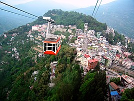 Ropeway, Gangtok
 -
-
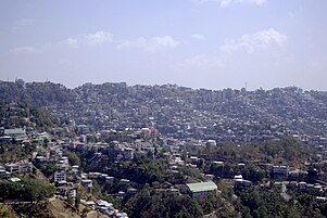
 Aerial view of Shillong
 -
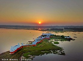 Neer Mahal of Tripura
 -

-

-

-

-
-
 Nohkalikai Falls, Cherrapunji, Meghalaya


Topography
Highest peaks

Kangchenjunga, the third highest mountain peak in the world rising to an altitude of 8,586 m (28,169 ft), lies in-between the state Sikkim and adjacent country Nepal.