A | B | C | D | E | F | G | H | CH | I | J | K | L | M | N | O | P | Q | R | S | T | U | V | W | X | Y | Z | 0 | 1 | 2 | 3 | 4 | 5 | 6 | 7 | 8 | 9
Niagara Falls | |
|---|---|
| City of Niagara Falls | |
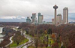
 The skyline of Niagara Falls near the edge of the Horseshoe Falls (at left), including the Skylon Tower, the Fallsview Casino, and several high-rise hotels | |
| Nickname(s): The Honeymoon Capital of the World, the Falls | |
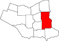
 Location of Niagara Falls in the Niagara Region | |
| Coordinates: 43°03′36″N 79°06′24″W / 43.06000°N 79.10667°W | |
| Country | |
| Province | |
| Regional municipality | Niagara |
| Settled | 1782 |
| Incorporated | 12 June 1903 |
| Government | |
| • Mayor | Jim Diodati |
| • Governing body | Niagara Falls City Council |
| • MP | Tony Baldinelli |
| • MPP | Wayne Gates |
| Area | |
| • Land | 209.73 km2 (80.98 sq mi) |
| • Urban | 382.68 km2 (147.75 sq mi) |
| • Metro | 1,397.50 km2 (539.58 sq mi) |
| Population | |
| • City (lower-tier) | 88,071 (Ranked 64th) |
| • Density | 419.9/km2 (1,088/sq mi) |
| • Urban | 242,460 (Ranked 17th) |
| • Urban density | 545.02/km2 (1,411.6/sq mi) |
| • Metro | 390,317 (Ranked 12th) |
| • Metro density | 279.3/km2 (723/sq mi) |
| Time zone | UTC−5 (EST) |
| • Summer (DST) | UTC−4 (EDT) |
| Forward Sortation Area | |
| Area code(s) | 905, 289, 365, and 742 |
| GNBC Code | FEDBA[4] |
| Website | www |
Niagara Falls is a city in Ontario, Canada. It is on the western bank of the Niagara River in the Golden Horseshoe region of Southern Ontario, with a population of 94,415 at the 2021 census.[5] It is part of the St. Catharines - Niagara Census Metropolitan Area (CMA). Incorporated on 12 June 1903, the city is across the river from Niagara Falls, New York. The Niagara River flows over Niagara Falls at this location, creating a natural spectacle which attracts millions of tourists each year.
The tourist area near the falls includes observation towers, high-rise hotels, souvenir shops, museums, indoor water parks, casinos and theatres, mostly with colourful neon billboards and advertisements. Other parts of the city include golf courses, parks, historic sites from the War of 1812, and residential neighbourhoods.
History
Prior to European arrival, present day Niagara Falls was populated by Iroquoian-speaking Neutral people but, after attacks from the Haudenosaunee and Seneca, the Neutral people population was severely reduced. The Haudenosaunee people remained in the area until Europeans made first contact in the late 17th century.[6] The Niagara Falls area had some European settlement in the 17th century. Louis Hennepin, a French priest and missionary, is considered to be the first European to visit the area in the 1670s. French colonists settled mostly in Lower Canada, beginning near the Atlantic, and in Quebec and Montreal.
After surveys were completed in 1782 the area was referred to as Township Number 2 as well as Mount Dorchester after Guy Carleton, 1st Baron Dorchester (and today is only honoured by Dorchester Road and the community of Dorchester Village).[7] The earliest settlers of Township Number 2 were Philip George Bender (namesake of Bender Street and Bender Hill near Casino Niagara originally from Germany and later New Jersey and Philadelphia[7]) and Thomas McMicken (a Scottish-born British Army veteran).[7] Increased settlement in this area took place during and after the American Revolutionary War, when the British Crown made land grants to Loyalists to help them resettle in Upper Canada and provide some compensation for their losses after the United States became independent. Loyalist Robert Land received 200 acres (81 ha) and was one of the first people of European descent to settle in the Niagara Region. He moved to nearby Hamilton three years later due to the relentless noise of the falls.[8]
In 1791, John Graves Simcoe renamed the town was Stamford after Stamford, Lincolnshire in England[7] but today Stamford is only used for an area northwest of downtown Niagara Falls as well as Stamford Street. During the war of 1812, the battle of Lundy's Lane took place in July 1814.[9] In 1856, the Town of Clifton was incorporated by Ogden Creighton after Clifton, Bristol. The name of the town was changed to Niagara Falls in 1881. In 1882, the community of Drummondville (near the present-day corner of Lundy's Lane and Main Street) was incorporated as the village of Niagara Falls (South). The village was referred to as Niagara Falls South to differentiate it from the town. In 1904, the town and village amalgamated to form the City of Niagara Falls. In 1963, the city amalgamated with the surrounding Stamford Township.[10] In 1970, the Niagara regional government was formed.[11] This resulted in the village of Chippawa, Willoughby Township, and part of Crowland Township being annexed into Niagara Falls.[12]
An internment camp for Germans was set up at The Armoury (now Niagara Military Museum) in Niagara Falls from December 1914 to August 1918.[13]
Black history

Niagara Falls has had a Black population since at least 1783. Up to 12 African-Americans were a part of the Butler's Rangers, including Richard Pierpoint. When they were disbanded in 1783, they tried to establish themselves through farming nearby, making them among the first Black settlers in the region.[14][15] It is estimated that nearly 10 percent of the Loyalists to settle in the area were Black Loyalists.[16]
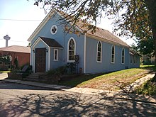
Niagara Falls' Black population increased in the following decades, as a destination on the Underground Railroad. In 1856, a British Methodist Episcopal (BME) Church was established for African-Canadian worshipers.[17] The BME Church, Nathaniel Dett Memorial Chapel is now a National Historic Site, remaining in operation into the 21st century.[18][19] Composer, organist, pianist and music professor Nathaniel Dett was born in Niagara Falls in 1882.[20]
In 1886, Burr Plato became one of the first African Canadians to be elected to political office, holding the position of City Councillor of Niagara Falls until 1901.[21][22]
Geography

Niagara Falls is approximately 130 km (81 mi) by road from Ontario's capital of Toronto, which is across Lake Ontario to the north. The area of the Niagara Region is approximately 1,800 km2 (690 sq mi).
Topography
The city is built along the Niagara Falls waterfalls and the Niagara Gorge on the Niagara River, which flows from Lake Erie to Lake Ontario.
Climate
The city of Niagara Falls has a humid continental climate (Köppen Dfa) which is moderated to an extent in all seasons by proximity to bodies of water. Winters are cold, with a January high of −0.4 °C (31.3 °F) and a low of −7.8 °C (18.0 °F).[23] However, temperatures above 0 °C (32.0 °F) are common during winter.[23] The average annual snowfall is 154 centimetres (61 in), in which it can receive lake effect snow from both lakes Erie and Ontario. Summers are warm to hot and humid, with a July high of 27.4 °C (81.3 °F) and a low of 17 °C (62.6 °F).[23] The average annual precipitation is 970.2 millimetres (38 in), which is relatively evenly distributed throughout the year.[citation needed]
| Climate data for Niagara Falls | |||||||||||||
|---|---|---|---|---|---|---|---|---|---|---|---|---|---|
| Month | Jan | Feb | Mar | Apr | May | Jun | Jul | Aug | Sep | Oct | Nov | Dec | Year |
| Record high °C (°F) | 22.2 (72.0) |
19.5 (67.1) |
26.5 (79.7) |
33.0 (91.4) |
35.0 (95.0) |
34.6 (94.3) |
38.4 (101.1) |
38.3 (100.9) |
35.6 (96.1) |
32.8 (91.0) |
24.4 (75.9) |
21.5 (70.7) |
38.4 (101.1) |
| Mean daily maximum °C (°F) | −0.4 (31.3) |
1.3 (34.3) |
5.9 (42.6) |
12.8 (55.0) |
19.4 (66.9) |
24.5 (76.1) |
27.4 (81.3) |
26.0 (78.8) |
21.9 (71.4) |
15.1 (59.2) |
8.7 (47.7) |
2.7 (36.9) |
13.8 (56.8) |
| Daily mean °C (°F) | −4.1 (24.6) |
−2.7 (27.1) |
1.2 (34.2) |
7.5 (45.5) |
13.6 (56.5) |
19.1 (66.4) |
22.2 (72.0) |
21.1 (70.0) |
17.1 (62.8) |
10.7 (51.3) |
4.9 (40.8) |
−0.7 (30.7) |
9.2 (48.6) |
| Mean daily minimum °C (°F) | −7.8 (18.0) |
−6.6 (20.1) |
−3.5 (25.7) |
2.2 (36.0) |
7.7 (45.9) |
13.7 (56.7) |
17.0 (62.6) |
16.2 (61.2) |
12.3 (54.1) |
6.3 (43.3) |
1.1 (34.0) |
−4.1 (24.6) |
4.5 (40.1) |
| Record low °C (°F) | −26 (−15) |
−25 (−13) |
−20 (−4) |
−13.5 (7.7) |
−4.4 (24.1) |
2.2 (36.0) |
5.6 (42.1) |
1.0 (33.8) |
0.0 (32.0) |
−6.7 (19.9) |
−12.5 (9.5) |
−24 (−11) |
−26 (−15) |
| Average precipitation mm (inches) | 75.6 (2.98) |
61.8 (2.43) |
61.7 (2.43) |
72.0 (2.83) |
86.8 (3.42) |
80.9 (3.19) |
78.9 (3.11) |
79.2 (3.12) |
98.2 (3.87) |
79.7 (3.14) |
91.8 (3.61) |
81.1 (3.19) |
947.5 (37.30) |
| Average rainfall mm (inches) | 27.8 (1.09) |
29.6 (1.17) |
36.7 (1.44) |
66.0 (2.60) |
85.9 (3.38) |
80.9 (3.19) |
78.9 (3.11) |
79.2 (3.12) |
98.2 (3.87) |
79.7 (3.14) |
81.9 (3.22) |
49.3 (1.94) |
794.0 (31.26) |
| Average snowfall cm (inches) | 47.7 (18.8) |
32.2 (12.7) |
25.0 (9.8) |
6.0 (2.4) |
0.9 (0.4) |
0.0 (0.0) |
0.0 (0.0) |
0.0 (0.0) |
0.0 (0.0) |
0.0 (0.0) |
9.8 (3.9) |
31.8 (12.5) |
153.5 (60.4) |
| Average precipitation days (≥ 0.2 mm) | 14.4 | 11.4 | 11.3 | 12.6 | 13.5 | 11.3 | 10.9 | 10.8 | 11.2 | 13.0 | 13.0 | 13.4 | 146.6 |
| Average rainy days (≥ 0.2 mm) | 5.0 | 4.5 | 7.2 | 11.6 | 13.4 | 11.3 | 10.9 | 10.8 | 11.2 | 13.0 | 11.1 | 7.7 | 117.9 |
| Average snowy days (≥ 0.2 cm) | 9.8 | 7.7 | 5.0 | 1.6 | 0.08 | 0.0 | 0.0 | 0.0 | 0.0 | 0.0 | 2.4 | 6.6 | 33.2 |
| Source 1: Environment Canada (normals 1981–2010, extremes 1981–2006)[24] | |||||||||||||
| Source 2: Environment Canada (extremes for Niagara Falls 1943−1995)[23] | |||||||||||||
Communities and neighbourhoods
Although more historical and cultural diversity exists, Niagara Falls has 11 communities and 67 neighbourhoods defined by Planning Neighbourhoods and Communities for the City of Niagara Falls.[25]
- Beaverdams
- Hyott
- N.E.C. West
- Nichols
- Shriners
- Warner
- Chippawa
- Bridgewater
- Cummings
- Hunter
- Kingsbridge
- Ussher
- Weinbrenner
- Crowland
- Crowland
- Drummond
- Brookfield
- Caledonia
- Coronation
- Corwin
- Drummond Industrial Basin
- Hennepin
- Leeming
- Merrit
- Miller
- Orchard
- Trillium
- Elgin
- Balmoral
- Central Business District
- Glenview
- Hamilton
- Maple
- Oakes
- Ryerson
- Valleyway
- Grassybrook
- Grassybrook Industrial Basin
- Oakland
- Rexinger
- Northwest
- Carmel
- Kent
- Mulhearn
- Queen Victoria
- Clifton Hill
- Fallsview North
- Fallsview South
- Marineland
- Queen Victoria
- Stamford
- Burdette
- Calaguiro
- Church
- Cullimore
- Gauld
- Ker
- Mitchellson
- Mountain
- N.E.C. East
- Olden
- Pettit
- Portage
- Queensway Gardens
- Rolling Acres
- Thompson
- Wallice
- Westlane
- Garner
- Hodgson Zdroj:https://en.wikipedia.org?pojem=Niagara_Falls,_Ontario
Text je dostupný za podmienok Creative Commons Attribution/Share-Alike License 3.0 Unported; prípadne za ďalších podmienok. Podrobnejšie informácie nájdete na stránke Podmienky použitia.
Antropológia
Aplikované vedy
Bibliometria
Dejiny vedy
Encyklopédie
Filozofia vedy
Forenzné vedy
Humanitné vedy
Knižničná veda
Kryogenika
Kryptológia
Kulturológia
Literárna veda
Medzidisciplinárne oblasti
Metódy kvantitatívnej analýzy
Metavedy
Metodika
Text je dostupný za podmienok Creative
Commons Attribution/Share-Alike License 3.0 Unported; prípadne za ďalších
podmienok.
Podrobnejšie informácie nájdete na stránke Podmienky
použitia.
www.astronomia.sk | www.biologia.sk | www.botanika.sk | www.dejiny.sk | www.economy.sk | www.elektrotechnika.sk | www.estetika.sk | www.farmakologia.sk | www.filozofia.sk | Fyzika | www.futurologia.sk | www.genetika.sk | www.chemia.sk | www.lingvistika.sk | www.politologia.sk | www.psychologia.sk | www.sexuologia.sk | www.sociologia.sk | www.veda.sk I www.zoologia.sk


