

A | B | C | D | E | F | G | H | CH | I | J | K | L | M | N | O | P | Q | R | S | T | U | V | W | X | Y | Z | 0 | 1 | 2 | 3 | 4 | 5 | 6 | 7 | 8 | 9
Mount Holly, New Jersey | |
|---|---|
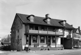
 John Woolman Memorial in Mount Holly | |
 Seal | |
 Location of Mount Holly in Burlington County highlighted in red (right). Inset map: Location of Burlington County in New Jersey highlighted in red (left). | |
 Census Bureau map of Mount Holly Township, New Jersey
 Interactive map of Mount Holly, New Jersey | |
 Mount Holly Location in Burlington County  Mount Holly Location in New Jersey  Mount Holly Location in the United States | |
| Coordinates: 39°59′43″N 74°47′11″W / 39.995336°N 74.786473°W[1][2] | |
| Country | |
| State | |
| County | Burlington |
| Settled | 1677 |
| Formed | November 6, 1688 as Northampton |
| Incorporated | February 21, 1798 |
| Renamed | November 6, 1931 as Mount Holly |
| Named for | Hill covered with holly trees |
| Government | |
| • Type | Faulkner Act (council–manager) |
| • Body | Township Council |
| • Mayor | Chris Banks (D)[3][4] |
| • Township Manager | Joshua Brown[5] |
| • Municipal clerk | Sherry Marnell[6] |
| Area | |
| • Total | 2.87 sq mi (7.43 km2) |
| • Land | 2.82 sq mi (7.31 km2) |
| • Water | 0.05 sq mi (0.12 km2) 1.60% |
| • Rank | 345th of 565 in state 31st of 40 in county[1] |
| Elevation | 36 ft (11 m) |
| Population | |
| • Total | 9,981 |
| • Estimate | 10,151 |
| • Rank | 245th of 565 in state 15th of 40 in county[12] |
| • Density | 3,534.3/sq mi (1,364.6/km2) |
| • Rank | 192nd of 565 in state 9th of 40 in county[12] |
| Time zone | UTC−05:00 (Eastern (EST)) |
| • Summer (DST) | UTC−04:00 (Eastern (EDT)) |
| ZIP Code | |
| Area code | 609[15] |
| FIPS code | 3400548900[1][16][17] |
| GNIS feature ID | 0882104[1][18] |
| Website | www |
Mount Holly is a township that is the county seat of Burlington County in the U.S. state of New Jersey. It is an eastern suburb of Philadelphia, the nation's sixth largest city as of 2020. As of the 2020 United States census, the township's population was 9,981,[9][10] an increase of 445 (+4.7%) from the 2010 census count of 9,536,[19][20] which in turn reflected a decline of 1,192 (-11.1%) from the 10,728 counted in the 2000 census.[21] The township, and all of Burlington County, is a part of the Philadelphia-Reading-Camden combined statistical area and the Delaware Valley.[22]
What is now Mount Holly was originally formed as Northampton on November 6, 1688. Northampton was incorporated as one of New Jersey's initial group of 104 townships created by an act of the New Jersey Legislature on February 21, 1798. Portions of the township were taken to form Little Egg Harbor Township (February 13, 1740, now part of Ocean County), Washington Township (November 19, 1802), Pemberton borough (December 15, 1826), Coaxen Township (March 10, 1845, now known as Southampton Township), Pemberton Township (March 10, 1846), Westampton Township (March 6, 1850) and Lumberton Township (March 14, 1860). There had been a Mount Holly post office since before the 1870 U.S. Census. The township was renamed Mount Holly as of November 6, 1931, based on the results of a referendum held three days earlier.[23] The township was named for hills covered with holly trees.[24][25] Some areas of today's Mount Holly were known as Bridgetown.[26][27][28]
Mount Holly gives its name to the National Weather Service Weather Forecast Office for the Philadelphia metropolitan area, though the office is actually located in adjacent Westampton.[29][30]
History
Colonial era
The first European settlement in what is now Mount Holly began in 1677 when Walter Reeves acquired land from the Lenape (Delaware) Native Americans living in the area. He constructed a dam on Rancocas Creek to channel water through a raceway to power a gristmill and sawmill.[31] Edward Gaskill and his sons dug the mill race on their property between 1720 and 1723.[32] After the mills were established, more settlers were attracted to the area and built houses and commercial buildings on High, Church, White, Mill, and Pine streets, including the Shinn Curtis Log House (1712). By 1800, over 250 dwellings had been built.[33]
Today no mills remain on the raceway, which still flows in its original course from the Rancocas just above the dam. The raceway proved a way for herring to make their way above the dam and was the scene of an annual fish run in the spring, which provided fresh herring for salting and eating. The former mill land has been preserved as the Mill Dam Park. It marks the importance of mills to the early settlements.
Revolutionary War
On December 17, 1776, Colonel Samuel Griffin of the Continental Army crossed the Delaware River with 600 men, mostly untrained men and boys with little equipment, who marched to Mount Holly where they set up a few 3-pounder artillery pieces on Iron Works Hill. Hessian commanders von Block and Carl von Donop were told that there were 3,000 American troops at Mount Holly.
By December 23, 1776, 2,000 Hessians were moved from Bordentown and positioned at The Mount in Mount Holly, where they engaged in a three-day-long artillery exchange, known as the Battle of Iron Works Hill or Battle of Mount Holly, with the Americans on Iron Works Hill. The Americans slipped away that night.[34]
After George Washington crossed the Delaware River on December 25, 1776, the fact that thousands of Hessian troops had been drawn to Mount Holly aided in the Continental Army's success in the Battle of Trenton the next day, a surprising American victory that helped turn the Army's fading morale after the disastrous defeat at the Battle of Fort Washington just weeks before and the ignominious retreat through New Jersey.[35]
19th century
The 1793 state legislature approved the relocation of the Burlington County seat from Burlington City to Mount Holly, which was approved by voters in a 1796 referendum.[36][37][page needed] Several important municipal buildings were constructed, including the courthouse in 1796 and the county prison built c. 1819. The Burlington County Prison was designed by Robert Mills, a nationally known architect who designed the Washington Monument. The town has numerous 18th and 19th-century buildings, most of which are included in the Mount Holly Historic District.[38] Commercial buildings were constructed primarily along High Street.
In 1849, the Burlington and Mount Holly Railroad was established, connecting communities along the Delaware River to Philadelphia, the major city of the area. The railroad supported industrialization along its route. The Camden and Mount Holly Railroad constructed a station 20 years later near the intersection of Washington and King streets.
20th century
A trolley station was built in 1904 for passengers making connections to Burlington City and Moorestown. New municipal buildings were constructed during the 20th century, including the Town Hall on Washington Street (1930) and the U.S. Post Office (1935) located across the street (1935), both federally funded and constructed as Works Progress Administration projects under President Franklin D. Roosevelt during the Great Depression.
In the late 1950s, Mount Holly began to have economic difficulties due to industrial restructuring and the loss of working-class jobs. In the post-World War II period, numerous blue collar, family wage jobs disappeared as the community's traditional employers, the mills and dye factories, were shut down. At first, these job losses were offset in part by gains at the nearby military bases, Fort Dix and McGuire Air Force Base, especially during the Vietnam War. In 1970, the residential vacancy rate in Mount Holly was 4.3%.
By 1980, however, the vacancy rate had climbed to 8.7% as a result of the nearby military installations' downsizing after the end of the Vietnam War. During this same period, 1970–1980, shopping malls proliferated in the suburban Philadelphia area, and retail business in Mount Holly suffered.[39]
Historic district
Mount Holly Historic District | |
 Downtown Mount Holly along High Street | |
| Location | Roughly bounded by Prospect, Elm and Top-E-Toy Streets, railroad tracks, Madison and Clifton Avenues |
|---|---|
| Area | 260 acres (110 ha) |
| Architectural style | Late Victorian, Georgian, Gothic Revival |
| NRHP reference No. | 73001084[40] |
| NJRHP No. | 842[41] |
| Significant dates | |
| Added to NRHP | February 20, 1973 |
| Designated NJRHP | August 7, 1972 |
The Mount Holly Historic District is a 260-acre (110 ha) historic district encompassing downtown Mount Holly. It was added to the National Register of Historic Places on February 20, 1973, for its significance in architecture, education, landscape architecture, politics/government, and transportation. The district includes 39 contributing buildings. The individually listed Old Schoolhouse, also known as the Brainerd School, was built in 1759 and contributes to the district. The Burlington County Prison is also listed individually and was listed as a National Historic Landmark in 1986. The Burlington County Courthouse was designed by architect Samuel Lewis and constructed by Michael Rush in 1796.[42][43]
-
 Burlington County Courthouse, HABS photo, 1936
 -
 Burlington County Prison, HABS photo, 1938
 -
 Three Tun Tavern, HABS photo, 1937
 -
 Stephen Girard House, HABS photo, 1937

.jpg)


Geography
According to the U.S. Census Bureau, the township had a total area of 2.87 square miles (7.43 km2), including 2.82 square miles (7.31 km2) of land and 0.05 square miles (0.12 km2) of water (1.60%).[1][2] The township borders the Burlington County municipalities of Eastampton Township, Hainesport Township, Lumberton, and Westampton.[44][45][46] Clermont is an unincorporated community located within Mount Holly Township.[citation needed]
Climate
| Climate data for South Jersey Regional Airport 1991–2020 normals, extremes 1997–present | |||||||||||||
|---|---|---|---|---|---|---|---|---|---|---|---|---|---|
| Month | Jan | Feb | Mar | Apr | May | Jun | Jul | Aug | Sep | Oct | Nov | Dec | Year |
| Record high °F (°C) | 72 (22) |
77 (25) |
88 (31) |
95 (35) |
96 (36) |
99 (37) |
104 (40) |
100 (38) |
98 (37) |
94 (34) |
79 (26) |
74 (23) |
104 (40) |
| Mean daily maximum °F (°C) | 41.0 (5.0) |
44.0 (6.7) |
52.0 (11.1) |
63.5 (17.5) |
73.3 (22.9) |
81.9 (27.7) |
87.0 (30.6) |
84.8 (29.3) |
77.9 (25.5) |
66.3 (19.1) |
55.6 (13.1) |
45.6 (7.6) |
64.4 (18.0) |
| Daily mean °F (°C) | 32.8 (0.4) |
34.8 (1.6) |
42.5 (5.8) |
52.6 (11.4) |
62.2 (16.8) |
71.5 (21.9) |
76.6 (24.8) |
74.4 (23.6) |
67.2 (19.6) |
55.9 (13.3) |
45.7 (7.6) |
37.4 (3.0) |
54.5 (12.5) |
| Mean daily minimum °F (°C) | 24.6 (−4.1) |
25.7 (−3.5) |
32.9 (0.5) |
41.6 (5.3) |
51.1 (10.6) |
61.0 (16.1) |
66.2 (19.0) |
64.0 (17.8) |
56.5 (13.6) |
45.6 (7.6) |
35.9 (2.2) |
29.1 (−1.6) |
44.5 (6.9) |
| Record low °F (°C) | −3 (−19) |
−2 (−19) |
2 (−17) |
22 (−6) |
34 (1) |
42 (6) |
43 (6) |
44 (7) |
37 (3) |
27 (−3) |
13 (−11) |
7 (−14) |
−3 (−19) |
| Average precipitation inches (mm) | 2.97 (75) |
2.57 (65) |
3.83 (97) |
3.37 (86) |
2.95 (75) |
3.73 (95) |
5.19 (132) |
4.40 (112) |
3.39 (86) |
3.67 (93) |
2.98 (76) |
3.74 (95) |
42.79 (1,087) |
| Average precipitation days (≥ 0.01 in) | 9.9 | 10.4 | 11.5 | 10.7 | 12.1 | 11.7 | 11.2 | 11.3 | 11.1 | 11.0 | 8.9 | 10.5 | 130.3 |
| Source: NOAA[47][48] | |||||||||||||
Demographics
| Census | Pop. | Note | %± |
|---|---|---|---|
| 1800 | 3,559 | — | |
| 1810 | 4,171 | * | 17.2% |
| 1820 | 4,833 | 15.9% | |
| 1830 | 5,516 | * | 14.1% |
| 1840 | 6,813 | 23.5% | |
| 1850 | 3,031 | * | −55.5% |
| 1860 | 3,322 | 9.6% | |
| 1870 | 4,018 | * | 21.0% |
| 1880 | 4,630 | 15.2% | |
| 1890 | 5,376 | 16.1% | |
| 1900 | 5,168 | −3.9% | |
| 1910 | 5,652 | 9.4% | |
| 1920 | 5,901 | 4.4% | |
| 1930 | 6,573 | 11.4% | |
| 1940 | 6,892 | 4.9% | |
| 1950 | 8,206 | 19.1% | |
| 1960 | 13,271 | 61.7% | |
| 1970 | 12,713 | −4.2% | |
| 1980 | 10,818 | −14.9% | |
| 1990 | 10,639 | −1.7% | |
| 2000 | 10,728 | 0.8% | |
| 2010 | 9,536 | −11.1% | |
| 2020 | 9,981 | 4.7% | |
| 2023 (est.) | 10,151 | [9][11] | 1.7% |
| Population sources: 1800–2000[49] 1800–1920[50] 1840[51] 1850–1870[52] 1850[53] 1870[54] 1880–1890[55] 1890–1910[56] 1910–1930[57] 1940–2000[58] 2000[59][60] 2010[19][20] 2020[9][10] * = Lost territory in previous decade.[23] | |||
2010 census
The 2010 United States census counted 9,536 people, 3,456 households, and 2,264 families in the township. The population density was 3,397.9 per square mile (1,311.9/km2). There were 3,861 housing units at an average density of 1,375.8 per square mile (531.2/km2). The racial makeup was 65.57% (6,253) White, 23.10% (2,203) Black or African American, 0.37% (35) Native American, 1.47% (140) Asian, 0.07% (7) Pacific Islander, 4.29% (409) from other races, and 5.13% (489) from two or more races. Hispanic or Latino of any race were 12.69% (1,210) of the population.[19]
Of the 3,456 households, 28.7% had children under the age of 18; 42.6% were married couples living together; 16.9% had a female householder with no husband present and 34.5% were non-families. Of all households, 27.4% were made up of individuals and 8.6% had someone living alone who was 65 years of age or older. The average household size was 2.61 and the average family size was 3.19.[19]
23.5% of the population were under the age of 18, 9.6% from 18 to 24, 28.7% from 25 to 44, 27.1% from 45 to 64, and 11.1% who were 65 years of age or older. The median age was 36.3 years. For every 100 females, the population had 102.8 males. For every 100 females ages 18 and older there were 100.1 males.[19]
The Census Bureau's 2006–2010 American Community Survey showed that (in 2010 inflation-adjusted dollars) median household income was $53,841 (with a margin of error of ±$4,427) and the median family income was $68,500 (±$4,684). Males had a median income of $51,945 (±$5,141) versus $37,079 (±$5,759) for females. The per capita income for the borough was $24,551 (±$1,785). About 7.1% of families and 12.2% of the population were below the poverty line, including 21.4% of those under age 18 and 8.8% of those age 65 or over.[61]
2000 census
As of the 2000 United States census,[16] there were 10,728 people, 3,903 households, and 2,583 families residing in the township. The population density was 3,750.8 inhabitants per square mile (1,448.2/km2). There were 4,248 housing units at an average density of 1,485.2 per square mile (573.4/km2). The racial makeup of the township was 68.68% White, 21.57% African American, 0.42% Native American, 1.37% Asian, 0.07% Pacific Islander, 4.77% from other races, and 3.12% from two or more races. Hispanic or Latino of any race were 8.78% of the population.[59][60]
There were 3,903 households, out of which 32.0% had children under the age of 18 living with them, 44.0% were married couples living together, 17.3% had a female householder with no husband present, and 33.8% were non-families. 27.2% of all households were made up of individuals, and 10.0% had someone living alone who was 65 years of age or older. The average household size was 2.64 and the average family size was 3.20.[59][60]
In the township, the age distribution of the population shows 26.3% under the age of 18, 9.4% from 18 to 24, 32.2% from 25 to 44, 19.6% from 45 to 64, and 12.4% who were 65 years of age or older. The median age was 35 years. For every 100 females, there were 99.7 males. For every 100 females age 18 and over, there were 96.6 males.[59][60]
The median income for a household in the township was $43,284, and the median income for a family was $52,000. Males had a median income of $38,186 versus $27,425 for females. The per capita income for the township was $19,672. About 6.8% of families and 9.9% of the population were below the poverty line, including 11.4% of those under age 18 and 10.4% of those age 65 or over.[59][60]
Economy
Portions of the township are part of an Urban Enterprise Zone (UEZ), one of 32 zones covering 37 municipalities statewide. Mount Holly was selected in 1994 as one of a group of 10 zones added to participate in the program and one of four of those chosen based on a competition.[62] In addition to other benefits to encourage employment and investment within the UEZ, shoppers can take advantage of a reduced 3.3125% sales tax rate (half of the 6+5⁄8% rate charged statewide) at eligible merchants.[63] Established in March 1995, the city's Urban Enterprise Zone status expires in March 2026.[64] The Township Council appoints a board of directors that oversees the operations of the Urban Enterprise Zone, which is managed by Joshua Brown, the township's Economic Development Director.[65]
Government
Local government

Mount Holly Township operates within the Faulkner Act (formally known as the Optional Municipal Charter Law) under the Council-Manager (plan 12) form of municipal government, enacted by council-initiated action as of July 1, 1990.[66] This form is used in 42 (of the 564) municipalities statewide.[67] The township council is comprised of five members who are elected at-large in a partisan vote to serve four-year terms of office on a staggered basis, with either two or three seats up for election in even-numbered years as part of the November general election.[7][68][69] At a reorganization meeting after each election, the council selects a mayor and a deputy mayor from among its members.[70] In November 2011, voters passed a referendum shifting from non-partisan municipal elections in May to partisan elections in November.[71]
As of 2023[update], members of the Mount Holly Township Council are Mayor Chris Banks (D, term on council ends December 31, 2024; term as mayor ends 2023), Deputy mayor Jason Jones (D, term on council ends 2024; term as deputy mayor ends 2023), Tara E. Astor (D, 2025), Lewis Brown (D, 2024) and Kim Burkus (D, 2025).[3][72][73][74][75]
Federal, state, and county representation
Mount Holly Township is located in the 3rd Congressional District[76] and is part of New Jersey's 8th state legislative district.[77][78][79]
For the 118th United States Congress, New Jersey's 3rd congressional district is represented by Andy Kim (D, Moorestown).[80] New Jersey is represented in the United States Senate by Democrats Cory Booker (Newark, term ends 2027)[81] and Bob Menendez (Englewood Cliffs, term ends 2025).[82][83]
For the 2024-2025 session, the 8th legislative district of the New Jersey Legislature is represented in the New Jersey Senate by Latham Tiver (R, Southampton Township) and in the General Assembly by Andrea Katz (D, Chesterfield Township) and Michael Torrissi (R, Hammonton).[84]
Burlington County is governed by a Board of County Commissioners composed of five members who are chosen at-large in partisan elections to serve three-year terms of office on a staggered basis, with either one or two seats coming up for election each year; at an annual reorganization meeting, the board selects a director and deputy director from among its members to serve a one-year term.[85] As of 2024[update], Burlington County's Commissioners are: Director Felicia Hopson (D, Willingboro Township, 2024),[86] Tom Pullion (D, Edgewater Park, 2026),[87] Allison Eckel (D, Medford, 2025),[88] Deputy Director Daniel J. O'Connell (D, Delran Township, 2024)[89] and Balvir Singh (D, Burlington Township, 2026).[90][85][91][92][93][94]
Burlington County's Constitutional Officers are: Clerk Joanne Schwartz (D, Southampton Township, 2028)[95][96] Sheriff James H. Kostoplis (D, Bordentown, 2025)[97][98] and Surrogate Brian J. Carlin (D, Burlington Township, 2026).[99][100]
Politics
As of March 2011, there were a total of 5,251 registered voters in Mount Holly Township, of which 1,718 (32.7% vs. 33.3% countywide) were registered as Democrats, 1,034 (19.7% vs. 23.9%) were registered as Republicans and 2,496 (47.5% vs. 42.8%) were registered as Unaffiliated. There were 3 voters registered as Libertarians or Greens.[101] Among the township's 2010 Census population, 55.1% (vs. 61.7% in Burlington County) were registered to vote, including 72.0% of those ages 18 and over (vs. 80.3% countywide).[101][102]
In the 2012 presidential election, Democrat Barack Obama received 2,636 votes here (68.1% vs. 58.1% countywide), ahead of Republican Mitt Romney with 1,127 votes (29.1% vs. 40.2%) and other candidates with 53 votes (1.4% vs. 1.0%), among the 3,870 ballots cast by the township's 5,578 registered voters, for a turnout of 69.4% (vs. 74.5% in Burlington County).[103][104] In the 2008 presidential election, Democrat Barack Obama received 2,771 votes here (67.2% vs. 58.4% countywide), ahead of Republican John McCain with 1,272 votes (30.8% vs. 39.9%) and other candidates with 58 votes (1.4% vs. 1.0%), among the 4,125 ballots cast by the township's 5,473 registered voters, for a turnout of 75.4% (vs. 80.0% in Burlington County).[105] In the 2004 presidential election, Democrat John Kerry received 2,223 votes here (57.2% vs. 52.9% countywide), ahead of Republican George W. Bush with 1,612 votes (41.5% vs. 46.0%) and other candidates with 37 votes (1.0% vs. 0.8%), among the 3,887 ballots cast by the township's 5,301 registered voters, for a turnout of 73.3% (vs. 78.8% in the whole county).[106]
In the 2013 gubernatorial election, Republican Chris Christie received 1,251 votes here (56.9% vs. 61.4% countywide), ahead of Democrat Barbara Buono with 891 votes (40.5% vs. 35.8%) and other candidates with 21 votes (1.0% vs. 1.2%), among the 2,200 ballots cast by the township's 5,429 registered voters, yielding a 40.5% turnout (vs. 44.5% in the county).[107][108] In the 2009 gubernatorial election, Democrat Jon Corzine received 1,126 ballots cast (49.6% vs. 44.5% countywide), ahead of Republican Chris Christie with 977 votes (43.1% vs. 47.7%), Independent Chris Daggett with 118 votes (5.2% vs. 4.8%) and other candidates with 38 votes (1.7% vs. 1.2%), among the 2,269 ballots cast by the township's 5,524 registered voters, yielding a 41.1% turnout (vs. 44.9% in the county).[109]
Education
For pre-kindergarten through eighth grade, students attend the Mount Holly Township Public Schools.[110] As of the 2021–22 school year, the district, comprised of three schools, had an enrollment of 1,079 students and 102.0 classroom teachers (on an FTE basis), for a student–teacher ratio of 10.6:1.[111] Schools in the district (with 2021–22 enrollment data from the National Center for Education Statistics[112]) are John Brainerd School[113] with 293 students in grades PreK-1, Gertrude C. Folwell School[114] with 302 students in grades 2-4, and F. W. Holbein Middle School[115] with 439 students in grades 6-8.[116][117][118]
For ninth through twelfth grades, public school students attend the Rancocas Valley Regional High School, a comprehensive regional public high school based in Mount Holly that serves students from five communities encompassing an area of 40 square miles (100 km2) that also includes the communities of Eastampton Township, Hainesport Township, Lumberton and Westampton.[119][120][121] As of the 2021–22 school year, the high school had an enrollment of 2,048 students and 140.3 classroom teachers (on an FTE basis), for a student–teacher ratio of 14.6:1.[122] The school is located in Mount Holly. The district's board of education is comprised of nine members who are elected directly by voters to serve three-year terms of office on a staggered basis, with three seats up for election each year as part of the November general election. Seats on the board are allocated based on the population of the five constituent municipalities, with two seats assigned to Mount Holly.[123][124]
Students from Mount Holly, and from all of Burlington County, are eligible to attend the Burlington County Institute of Technology, a countywide public school district that serves the vocational and technical education needs of students at the high school and post-secondary level at its campuses in Medford and Westampton.[125]
Sacred Heart School is a Catholic school serving students in grades PreK-8, operating under the auspices of the Roman Catholic Diocese of Trenton.[126][127]
Transportation
_in_Mount_Holly_Township,_Burlington_County,_New_Jersey.jpg)
Roads and highways
As of May 2010[update], the township had a total of 38.43 miles (61.85 km) of roadways, of which 29.11 miles (46.85 km) were maintained by the municipality, 8.45 miles (13.60 km) by Burlington County and 0.87 miles (1.40 km) by the New Jersey Department of Transportation.[128]
The only state highway serving Mount Holly is Route 38, which crosses from west to east at the township's southern end. Major county roads that pass through Mount Holly include County Route 537 and County Route 541.[129]
Mount Holly is accessible at exit 5 of the New Jersey Turnpike in neighboring Westampton and exit 47 of Interstate 295 via CR 541 in Burlington Township.[130]
Public transportation
NJ Transit provides bus service to Philadelphia on routes 317 (from Asbury Park) and 409/417/418 (from Trenton), with local service available on the 413 route between Camden and Burlington.[131][132]
Points of interest

- Burlington County Courthouse, 1796
- Mount Holly Cemetery
- Shinn Curtis Log House, constructed out of hand-hewn logs, the house was built in 1712; the original log house was uncovered in 1967. A larger house that had been built around it was demolished, revealing the early house beneath, which has been restored.[133]
- Burlington County Prison, opened in 1819, it was the oldest continually operated prison in the country when it closed in 1965 after more than 150 years of service.[134]
- First Presbyterian Church
- St. Andrew's Episcopal Church
- Friends Meeting House
- Brainerd Schoolhouse is a one-room schoolhouse that was constructed in 1759 and operated as a school for nearly 100 years. In 1951, the school was transferred from the Female Benevolent Society, which had owned and operated the site for 136 years, to the National Society of the Colonial Dames of America.[135]
- Relief Fire Company No. 1, home of the oldest continuously operating volunteer fire company in the United States.[28]
- Thomas Budd House is the township's third-oldest house, dating to 1744.[136]
- Stephen Girard House was the home of Girard, who moved to Mount Holly shortly after his marriage in 1777 and purchased the partially completed house, as recorded in 1779.[137]
- John Woolman Memorial was constructed in the late 1700s on a portion of an orchard that had belonged to Woolman.[138]
In popular cultureedit
The pop punk band The High Court from the township released the 2007 album Puppet Strings.[139]
Notable peopleedit
People who were born in, residents of, or otherwise closely associated with Mount Holly include:
- James William Abert (1820–1897), soldier, explorer, ornithologist and topographical artist[140][141]
- Gamaliel Bailey (1807–1859), journalist and early abolitionist[142]
- Cindy Birdsong (born 1939), singer who became famous as a member of The Supremes in 1967, when she replaced co-founding member Florence Ballard[143]
- Anthony S. Black (born 1951), jockey and Kentucky Derby winner[144]
- Charles C. Black (1858–1947), Associate Justice of the New Jersey Supreme Court who was the Democratic nominee for Governor of New Jersey in 1904[145]
- Zach Braddock (born 1987), pitcher who has played for the Milwaukee Brewers[146]
- Shaun Bradley (born 1997), American football linebacker for the Philadelphia Eagles[147]
- Samuel A. Dobbins (1814–1905), represented New Jersey's 2nd congressional district in the United States House of Representatives from 1873 to 1877[148]
- Paul Doguereau (1908–2000), pianist[149]
- Barrows Dunham (1905–1995), professor of philosophy who was fired in 1953 by Temple University after refusing to answer questions posed by the House Un-American Activities Committee[150]
- Doug Easlick (born 1980), fullback who played in the NFL for the Miami Dolphins in the 2004 season[151]
- Matthew Emmons (born 1981), sport shooter who won a gold medal in the 50-meter rifle prone event at the 2004 Summer Olympics in Athens[152]
- Pat Fidelia (born 1959), former professional soccer player[153]
- Samuel C. Forker (1821–1900), represented New Jersey's 2nd congressional district in the United States House of Representatives from 1871 to 1873[154]
- Mike Freeman (born 1961), former guard who played in the NFL for seasons with the Denver Broncos and Los Angeles Raiders[155]
- Irving Fryar (born 1962), former Philadelphia Eagles football player[156]
- Dan Gakeler (born 1964), former MLB pitcher who played for the Detroit Tigers during the 1991 season[157]
- Joseph H. Gaskill (1851–1935), judge on the New Jersey Court of Common Pleas and Justice of the New Jersey Supreme Court from 1893 to 1896[158]
- Ron Gassert (born 1940), former football player for the University of Virginia and the Green Bay Packers[159][160]
- John F. Gerry (1926–1995), former chief United States district judge on the United States District Court for the District of New Jersey[161]
- Ed Gillespie (born 1961), Republican political strategist who was a senior advisor to Mitt Romney's 2012 presidential campaign and former Counselor to the President for George W. Bush[162]
- Stephen Girard (1750–1831), merchant, banker, philanthropist, and humanitarian[163]
- Louis Greenwald (born 1967), member of the New Jersey General Assembly since 1996[164]
- Bessie Pease Gutmann (1876–1960), artist and illustrator[165][166]
- Franco Harris (born 1950), former Pittsburgh Steelers football player. Ranked #3 on the Sports Illustrated list of The 50 Greatest New Jersey Sports Figures[167]
- Pete Harris (1957–2006), All-American safety at Penn State University[168]
- Dwight Hicks (born 1956), defensive back who played in the NFL for the San Francisco 49ers and Indianapolis Colts[169]
- Edward Young Higbee (1810–1871), Episcopal clergyman who served as Chaplain of the United States Senate[170]
- Ernest Hilbert (born 1970), poet, opera librettist and rare book dealer[171]
- Peter Hill (1767–1820), former slave who was the first African American clockmaker[172]
- David Johnson (born 1964), rifle shooter who won a gold medal in the 10m air rifle event at the 1991 Pan American Games and competed at the 1992 Summer Olympics[173]
- Ruth G. King (born 1933), educational psychologist who was the first woman to serve as president of the Association of Black Psychologists[174]
- Leslie E. Kobayashi (born 1957), Judge of the United States District Court for the District of Hawaii[175]
- Kevin Landolt (born 1975), defensive tackle who played one season in the NFL for the Jacksonville Jaguars in 1999[176]
- Isabeau Levito (born 2007), figure skater who won the 2023 U.S. Figure Skating Championships and the 2024 World Figure Skating Championships silver medalist[177]
- Geraldine Clinton Little (1923–1997), poet[178]
- Mary Lum (1758–1815), moved here with her husband Stephen Girard in 1777 before being committed for the rest of her life to the insanity ward at Pennsylvania Hospital in 1785[179]
- Ricky Lumpkin (born 1988), NFL defensive tackle for the Oakland Raiders[180]
- Britt McHenry (born 1986), sports reporter[181]
- John A. Nagy, author of nonfiction history books on espionage and mutinies during the American Revolution[182]
- Barbara Park (1947–2013), author of children's literature best known for her series of books starring the character Junie B. Jones[183]
- Barry T. Parker (born 1932), member of the New Jersey General Assembly and State Senate[184]
- Frank Parsons (1854–1908), professor, social reformer and public intellectual[185]
- Charles Sreeve Peterson (1818–1889), founder of Morgan Valley, Utah, and co-founder of Mormon colonies in Mexico[citation needed]
- Jeremy Riddle (born 1977), Christian music singer.[186]
- Samuel K. Robbins (1853–1926), politician who served as Speaker of the New Jersey General Assembly and President of the New Jersey Senate[187]
- William Rossell (1760–1840), judge on the United States District Court for the District of New Jersey[188]
- Jim Saxton (born 1943), former representative from New Jersey's 3rd congressional district[189][190]
- Thomas C. Sharp (1818–1894), newspaper publisher and outspoken opponent of Joseph Smith who was charged (and acquitted) in the death of Smith[191]
- Charles V. Shank (born 1943), physicist who served as the director of the Lawrence Berkeley National Laboratory from 1989 to 2004[192]
- Robert C. Shinn Jr. (born 1937), politician who served in the New Jersey General Assembly from the 8th Legislative District from 1985 to 1994[193]
- Michael Sis (born 1960), sixth bishop of the Roman Catholic Diocese of San Angelo in Texas[194]
- Harrison Slater, pianist and mystery writer[195]
- Michelle Smith (born 1972/1973), fashion designer[196]
- José F. Sosa (born 1950), politician who was mayor of Mont Holly and served in the New Jersey General Assembly from 1992 to 1994[197]
- Alonzo Spellman (born 1971), defensive lineman who played in the NFL for the Chicago Bears, Dallas Cowboys and Detroit Lions[198]
- Earl W. Stafford (born 1948), entrepreneur and philanthropist[199]
- John L. N. Stratton (1817–1889), member of the United States House of Representatives from New Jersey[200]
- John C. Ten Eyck (1814–1879), politician who represented New Jersey in the United States Senate from 1859 to 1865[201]
- M. Louise Thomas (1822–1907), social reformer[citation needed]
- DeMya Walker (born 1977), professional basketball player[202]
- Barclay White (1821–1906), Superintendent of Indian Affairs during the administration of president Ulysses S. Grant[203]
- John Woolman (1720–1772), noted Quaker essayist and preacher, early anti-slavery advocate[204]
Referencesedit
- ^ a b c d e f 2019 Census Gazetteer Files: New Jersey Places, United States Census Bureau. Accessed July 1, 2020.
- ^ a b US Gazetteer files: 2010, 2000, and 1990, United States Census Bureau. Accessed September 4, 2014.
- ^ a b Council Members, Township of Mount Holly. Accessed February 1, 2023. "Township Council governs Mount Holly Township. Mount Holly is governed by five Council members, each of whom is elected for a four-year staggered term. At the beginning of each year, the Council members elect one of their members to serve as Mayor and one as Deputy Mayor for that year."
- ^ 2023 New Jersey Mayors Directory, New Jersey Department of Community Affairs, updated February 8, 2023. Accessed February 10, 2023.
- ^ Administration, Township of Mount Holly. Accessed March 9, 2023.
- ^ Clerk's Office, Township of Mount Holly. Accessed March 9, 2023.
- ^ a b 2012 New Jersey Legislative District Data Book, Rutgers University Edward J. Bloustein School of Planning and Public Policy, March 2013, p. 38.
- ^ U.S. Geological Survey Geographic Names Information System: Township of Mount Holly, Geographic Names Information System. Accessed March 8, 2013.
- ^ a b c d e QuickFacts Mount Holly township, Burlington County, New Jersey, United States Census Bureau. Accessed December 21, 2022.
- ^ a b c Total Population: Census 2010 - Census 2020 New Jersey Municipalities, New Jersey Department of Labor and Workforce Development. Accessed December 1, 2022.
- ^ a b Annual Estimates of the Resident Population for Minor Civil Divisions in New Jersey: April 1, 2020 to July 1, 2023, United States Census Bureau, released May 2024. Accessed May 16, 2024.
- ^ a b Population Density by County and Municipality: New Jersey, 2020 and 2021, New Jersey Department of Labor and Workforce Development. Accessed March 1, 2023.
- ^ Look Up a ZIP Code for Mount Holly, NJ, United States Postal Service. Accessed June 21, 2012.
- ^ Zip Codes, State of New Jersey. Accessed October 19, 2013.
- ^ Area Code Lookup – NPA NXX for Mount Holly, NJ, Area-Codes.com. Accessed October 19, 2013.
- ^ a b U.S. Census website, United States Census Bureau. Accessed September 4, 2014.
- ^ Geographic Codes Lookup for New Jersey, Missouri Census Data Center. Accessed April 1, 2022.
- ^ US Board on Geographic Names, United States Geological Survey. Accessed September 4, 2014.
- ^ a b c d e DP-1 – Profile of General Population and Housing Characteristics: 2010 for Mount Holly township, Burlington County, New Jersey Archived 2020-02-12 at archive.today, United States Census Bureau. Accessed June 21, 2012.
- ^ a b Profile of General Demographic Characteristics: 2010 for Mount Holly township Archived 2014-10-29 at the Wayback Machine, New Jersey Department of Labor and Workforce Development. Accessed June 21, 2012.
- ^ Table 7. Population for the Counties and Municipalities in New Jersey: 1990, 2000 and 2010, New Jersey Department of Labor and Workforce Development, February 2011. Accessed May 1, 2023.
- ^ New Jersey: 2020 Core Based Statistical Areas and Counties, United States Census Bureau. Accessed February 1, 2023.
- ^ a b Snyder, John P. The Story of New Jersey's Civil Boundaries: 1606–1968, Bureau of Geology and Topography; Trenton, New Jersey; 1969. p. 96. Accessed May 30, 2024.
- ^ Hutchinson, Viola L. The Origin of New Jersey Place Names, New Jersey Public Library Commission, May 1945. Accessed September 8, 2015.
- ^ Gannett, Henry. The Origin of Certain Place Names in the United States, p. 216. United States Government Printing Office, 1905. Accessed September 8, 2015.
- ^ Gordon, Thomas Francis. A Gazetteer of the State of New Jersey: Comprehending a General View of Its Physical and Moral Condition, Together with a Topographical and Statistical Account of Its Counties, Towns, Villages, Canals, Rail Roads, &c., Accompanied by a Map, p. 134. Daniel Fenton, 1834. Accessed June 20, 2017. "Mount Holly, p-t., Northampton t-ship, and seat of justice of Burlington co., on the road from Camden to Freehold, and at the head of tide and navigation, on the north branch of Rancocas creek, 20 miles N.E. from the city of Camden, 6 S.E. from Burlington, 21 from Trenton, 156 from W.C., and 18 from Philadelphia, has its present name from a mount of sand and sandstone near it and some holly trees about its base. It was formerly called Bridgetown; and this name was recognized in a charter for a library company here, so early as 1765."
- ^ Comegno, Carol. "Historic Burlington sites getting facelifts", Courier-Post, January 30, 2017. Accessed June 20, 2017. "King George III of England [sic] chartered the library in 1765 before the Revolutionary War when Colonial Mount Holly was known as Bridgetown."
- ^ a b Winchester, James H. "America's Oldest Volunteer Fire Group", Christian Science Monitor, December 29, 1961. Accessed June 21, 2012. "Some 210 years ago—nearly a quarter of a century before the adoption of the Declaration of Independence – 13 men gathered in the Town Hall at Bridgetown, N.J., which is now Mount Holly, to draw up the by-laws and create the Relief Volunteer Fire Company, now the oldest in the United States."
- ^ Weather Forecast Office Philadelphia / Mount Holly, National Weather Service. Accessed April 14, 2022.
Zdroj:https://en.wikipedia.org?pojem=Mount_Holly,_New_Jersey
Text je dostupný za podmienok Creative Commons Attribution/Share-Alike License 3.0 Unported; prípadne za ďalších podmienok. Podrobnejšie informácie nájdete na stránke Podmienky použitia.
Antropológia
Aplikované vedy
Bibliometria
Dejiny vedy
Encyklopédie
Filozofia vedy
Forenzné vedy
Humanitné vedy
Knižničná veda
Kryogenika
Kryptológia
Kulturológia
Literárna veda
Medzidisciplinárne oblasti
Metódy kvantitatívnej analýzy
Metavedy
Metodika
Text je dostupný za podmienok Creative
Commons Attribution/Share-Alike License 3.0 Unported; prípadne za ďalších
podmienok.
Podrobnejšie informácie nájdete na stránke Podmienky
použitia.
www.astronomia.sk | www.biologia.sk | www.botanika.sk | www.dejiny.sk | www.economy.sk | www.elektrotechnika.sk | www.estetika.sk | www.farmakologia.sk | www.filozofia.sk | Fyzika | www.futurologia.sk | www.genetika.sk | www.chemia.sk | www.lingvistika.sk | www.politologia.sk | www.psychologia.sk | www.sexuologia.sk | www.sociologia.sk | www.veda.sk I www.zoologia.sk