A | B | C | D | E | F | G | H | CH | I | J | K | L | M | N | O | P | Q | R | S | T | U | V | W | X | Y | Z | 0 | 1 | 2 | 3 | 4 | 5 | 6 | 7 | 8 | 9
McKean County | |
|---|---|
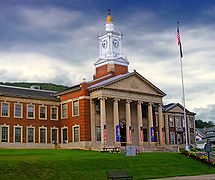
 McKean County Courthouse | |
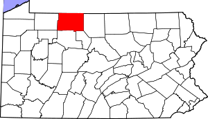
 Location within the U.S. state of Pennsylvania | |
 Pennsylvania's location within the U.S. | |
| Coordinates: 41°48′40″N 78°26′41″W / 41.811111111111°N 78.444722222222°W | |
| Country | |
| State | |
| Founded | September 1, 1826 |
| Named for | Thomas McKean |
| Seat | Smethport |
| Largest city | Bradford |
| Area | |
| • Total | 984 sq mi (2,550 km2) |
| • Land | 979 sq mi (2,540 km2) |
| • Water | 5.0 sq mi (13 km2) 0.5% |
| Population (2020) | |
| • Total | 40,432 |
| • Density | 41/sq mi (16/km2) |
| Time zone | UTC−5 (Eastern) |
| • Summer (DST) | UTC−4 (EDT) |
| Congressional district | 15th |
| Website | www |
McKean County is a rural county in the Commonwealth of Pennsylvania. As of the 2020 census, the population was 40,432.[1] Its county seat is Smethport.[2] The county was created in 1804 and organized in 1826.[3] It was named in honor of former Pennsylvania Governor and Declaration of Independence signer Thomas McKean.[4]
McKean County comprises the Bradford, Pennsylvania micropolitan statistical area. It is in a sparsely populated region known as the Pennsylvania Wilds. It includes the Allegheny National Forest and borders New York. McKean County boasts of being "The Black Cherry Capital of the World."
McKean County was founded because of its natural resources of oil and timber, both of which continue to provide a significant input to the economy. Today, a university, rural medical center, federal prison and manufacturing companies balance the area's economy.
Geography
According to the U.S. Census Bureau, the county has an area of 984 square miles (2,550 km2), of which 979 square miles (2,540 km2) is land and 5.0 square miles (13 km2) (0.5%) is water.[5] It has a warm-summer humid continental climate (Dfb) and average monthly temperatures in downtown Bradford range from 23.0 °F in January to 67.6 °F in July, while in Mount Jewett they range from 21.2 °F in January to 65.1 °F in July.[6]
Adjacent counties
- Cattaraugus County, New York (north)
- Allegany County, New York (northeast)
- Potter County (east)
- Cameron County (southeast)
- Elk County (south)
- Forest County (southwest)
- Warren County (west)
Major highways
National protected area
- Allegheny National Forest (part)
- Allegheny National Recreation Area (part)
Demographics
| Census | Pop. | Note | %± |
|---|---|---|---|
| 1810 | 142 | — | |
| 1820 | 728 | 412.7% | |
| 1830 | 1,439 | 97.7% | |
| 1840 | 2,975 | 106.7% | |
| 1850 | 5,254 | 76.6% | |
| 1860 | 8,859 | 68.6% | |
| 1870 | 8,825 | −0.4% | |
| 1880 | 42,565 | 382.3% | |
| 1890 | 46,863 | 10.1% | |
| 1900 | 51,343 | 9.6% | |
| 1910 | 47,868 | −6.8% | |
| 1920 | 48,934 | 2.2% | |
| 1930 | 55,167 | 12.7% | |
| 1940 | 56,673 | 2.7% | |
| 1950 | 56,607 | −0.1% | |
| 1960 | 54,517 | −3.7% | |
| 1970 | 51,915 | −4.8% | |
| 1980 | 50,653 | −2.4% | |
| 1990 | 47,131 | −7.0% | |
| 2000 | 45,963 | −2.5% | |
| 2010 | 43,450 | −5.5% | |
| 2020 | 40,432 | −6.9% | |
| U.S. Decennial Census[7] 1790–1960[8] 1900–1990[9] 1990–2000[10] 2010–2017[11][12] | |||
As of the 2000 census,[13] there were 45,936 people, 18,024 households, and 12,094 families residing in the county. The population density was 47 people per square mile (18 people/km2). There were 21,644 housing units at an average density of 22 units per square mile (8.5/km2). The racial makeup of the county was 96.46% White, 1.87% Black, 0.32% Native American, 0.30% Asian, 0.02% Pacific Islander, 0.40% from other races, and 0.61% from two or more races. 1.06% of the population were Hispanic or Latino of any race. 35.0% German, 22.2% Irish, 14.6% Italian, 12.3% English, 10.0% Swedish, 8.6% American, 5.8% Polish, and 3.7% French ancestry.
There were 18,024 households, out of which 30.50% had children under the age of 18 living with them, 52.50% were married couples living together, 10.10% had a female householder with no husband present, and 32.90% were non-families. 28.30% of all households were made up of individuals, and 13.30% had someone living alone who was 65 years of age or older. The average household size was 2.40 and the average family size was 2.93.
In the county, the age distribution of the population shows 23.70% under the age of 18, 7.90% from 18 to 24, 28.50% from 25 to 44, 23.20% from 45 to 64, and 16.70% who were 65 years of age or older. The median age was 39 years. For every 100 females there were 100.40 males. For every 100 females age 18 and over, there were 98.70 males.
2020 census
| Race | Num. | Perc. |
|---|---|---|
| White (NH) | 36,991 | 91.5% |
| Black or African American (NH) | 849 | 2.1% |
| Native American (NH) | 102 | 0.3% |
| Asian (NH) | 193 | 0.47% |
| Pacific Islander (NH) | 2 | 0.01% |
| Other/Mixed (NH) | 1,653 | 4.1% |
| Hispanic or Latino | 642 | 1.6% |
Micropolitan Statistical Area
The United States Office of Management and Budget[15] has designated McKean County as the Bradford, PA micropolitan statistical area (USA).[16] As of the 2010 U.S. Census[17] the micropolitan area ranked 13th most populous in Pennsylvania and the 277th most populous in the United States with a population of 43,450.
Law and government
| Year | Republican | Democratic | Third party | |||
|---|---|---|---|---|---|---|
| No. | % | No. | % | No. | % | |
| 2020 | 14,083 | 72.18% | 5,098 | 26.13% | 329 | 1.69% |
| 2016 | 11,635 | 70.67% | 4,025 | 24.45% | 804 | 4.88% |
| 2012 | 9,545 | 62.99% | 5,297 | 34.95% | 312 | 2.06% |
| 2008 | 9,224 | 57.61% | 6,465 | 40.38% | 321 | 2.00% |
| 2004 | 10,941 | 62.79% | 6,294 | 36.12% | 191 | 1.10% |
| 2000 | 9,661 | 61.12% | 5,510 | 34.86% | 635 | 4.02% |
| 1996 | 6,838 | 45.99% | 5,509 | 37.05% | 2,522 | 16.96% |
| 1992 | 6,965 | 42.47% | 5,331 | 32.51% | 4,104 | 25.02% |
| 1988 | 9,323 | 63.22% | 5,300 | 35.94% | 124 | 0.84% |
| 1984 | 10,963 | 69.22% | 4,818 | 30.42% | 58 | 0.37% |
| 1980 | 9,229 | 60.85% | 5,064 | 33.39% | 873 | 5.76% |
| 1976 | 10,305 | 60.88% | 6,424 | 37.95% | 197 | 1.16% |
| 1972 | 11,958 | 71.72% | 4,513 | 27.07% | 202 | 1.21% |
| 1968 | 10,506 | 59.67% | 6,326 | 35.93% | 775 | 4.40% |
| 1964 | 7,948 | 41.82% | 10,950 | 57.61% | 109 | 0.57% |
| 1960 | 13,699 | 63.62% | 7,767 | 36.07% | 66 | 0.31% |
| 1956 | 14,725 | 73.81% | 5,152 | 25.82% | 73 | 0.37% |
| 1952 | 15,256 | 73.43% | 5,373 | 25.86% | 147 | 0.71% |
| 1948 | 10,218 | 66.91% | 4,785 | 31.33% | 269 | 1.76% |
| 1944 | 11,988 | 64.45% | 6,492 | 34.90% | 121 | 0.65% |
| 1940 | 14,822 | 67.58% | 6,991 | 31.88% | 119 | 0.54% |
| 1936 | 11,837 | 53.37% | 9,733 | 43.88% | 611 | 2.75% |
| 1932 | 9,970 | 65.01% | 4,661 | 30.39% | 704 | 4.59% |
| 1928 | 14,012 | 73.49% | 4,964 | 26.04% | 90 | 0.47% |
| 1924 | 9,072 | 68.99% | 2,376 | 18.07% | 1,701 | 12.94% |
| 1920 | Zdroj:https://en.wikipedia.org?pojem=McKean_County||||||

