

A | B | C | D | E | F | G | H | CH | I | J | K | L | M | N | O | P | Q | R | S | T | U | V | W | X | Y | Z | 0 | 1 | 2 | 3 | 4 | 5 | 6 | 7 | 8 | 9
Luzerne County | |
|---|---|
 Seal | |
 Topographical map of Luzerne County, Pennsylvania | |
 Location of Luzerne County in Pennsylvania | |
| Country | United States |
| State | |
| Region | Northeastern Pennsylvania |
| Metro area | Wyoming Valley |
| Formed | September 25, 1786 |
| Named for | Chevalier de la Luzerne |
| County seat | Wilkes-Barre |
| Largest city | Wilkes-Barre |
| Government | |
| • Type | Council–manager |
| • Council | |
| • Council Chair | John Lombardo (R) |
| • Manager | Romilda Crocamo |
| Area | |
| • Total | 906 sq mi (2,350 km2) |
| • Land | 890 sq mi (2,300 km2) |
| • Water | 16 sq mi (40 km2) |
| Highest elevation | 2,460 ft (750 m) |
| Lowest elevation | 512 ft (156 m) |
| Population (2020) | |
| • Total | 325,594 |
| • Density | 360/sq mi (140/km2) |
| Time zone | UTC−5 (EST) |
| • Summer (DST) | UTC−4 (EDT) |
| Area codes | 570/272 |
| Website | www |
Luzerne County is a county in the Commonwealth of Pennsylvania. According to the United States Census Bureau, the county has a total area of 906 square miles (2,350 km2), of which 890 square miles (2,300 km2) is land and 16 square miles (41 km2) is water. It is Northeastern Pennsylvania's second-largest county by total area. As of the 2020 census, the population was 325,594, making it the most populous county in the northeastern part of the state. The county seat and most populous city is Wilkes-Barre.[1] Other populous communities include Hazleton, Kingston, Nanticoke, and Pittston. Luzerne County is included in the Scranton–Wilkes-Barre–Hazleton Metropolitan Statistical Area, which has a total population of 555,426 as of 2017.
On September 25, 1786, Luzerne County was formed from part of Northumberland County. It was named after Chevalier de la Luzerne, a French soldier and diplomat during the 18th century. When it was founded, Luzerne County occupied a large portion of Northeastern Pennsylvania. From 1810 to 1878, it was divided into several smaller counties. The counties of Bradford, Lackawanna, Susquehanna, and Wyoming were all formed from parts of Luzerne County.[2][3]
The county gained prominence in the 19th and 20th centuries as an active anthracite coal mining region, drawing a large portion of its labor force from European immigrants. At its peak (in 1930), the county's population was 445,109. Many factories and coal mines closed by the early 21st century. Like most regions in the Rust Belt, Luzerne County witnessed population loss and urban decay. However, in recent years, the economy has grown moderately; warehousing has replaced manufacturing as the main industry.[4]
History
The Luzerne County Historical Society maintains the storehouse for the collective memory of Luzerne County and its environs. It records and interprets the history, traditions, events, people, and cultures that have directed and molded life within the region.[5]
18th century


Long an area occupied by indigenous peoples, by the 1700s the Wyoming Valley was inhabited by several Native American tribes including the Susquehannock, who spoke an Iroquoian language, and the Delaware (Lenape), who spoke an Algonquian language. In the mid-18th century, Connecticut settlers of primarily English ancestry ventured into the valley. These were the first recorded Europeans in the region. Some came as missionaries to the Native American peoples, while others came to farm the fertile land near the Susquehanna River. Ultimately, the violence of the French and Indian War (the North American front of the Seven Years' War between Great Britain and France) drove these Connecticut settlers away.[6]
The British colonies of Pennsylvania and Connecticut both claimed the Wyoming Valley as their own. King Charles II of England had granted the land to the Connecticut Colony in 1662, but also to William Penn (the founder of Pennsylvania) in 1681. In 1769, Yankee settlers from Connecticut returned to the valley and founded the town of Wilkes-Barre. However, they were not alone. Pennsylvanian settlers (Pennamites) were also in the region.
Armed bands of Pennamites harassed the Connecticut settlers in what is known as the Pennamite-Yankee Wars. While the land dispute continued, a much larger conflict began. In 1775, the Thirteen Colonies began a war of independence against the colonial power of Great Britain. Residents of both Pennsylvania and Connecticut were largely loyal to the Patriot cause, which supported the American Revolution and independence.
On June 30, 1778, Loyalist forces, under the command of Major John Butler, arrived in the Wyoming Valley to attack the rebel American settlements. On July 1, Fort Wintermoot at the north end of the valley surrendered without a shot being fired. The next morning the smaller Fort Jenkins surrendered. Both forts were later burned to the ground.
Meanwhile, the Patriot militia assembled at Forty Fort. On July 3, a column of roughly 375 men, including a company of soldiers from the Continental Army, marched from the fort under the command of Lieutenant Colonel Zebulon Butler and Colonel Nathan Denison. Butler's Rangers, with the assistance of about 500 Native American allies, mostly Seneca, ambushed the approaching Americans. In the end, nearly 300 Wyoming Valley Patriots were killed in what is commonly known as the Wyoming Massacre.[7] Today, in the Borough of Wyoming, a monument marks the gravesite of the victims from the battle.[8]
The next day Colonel Denison surrendered Forty Fort along with several other posts. Widespread looting and burning of buildings occurred throughout the Wyoming Valley subsequent to this capitulation, but non-combatants were not harmed.[7] Most of the inhabitants, however, fled across the Pocono Mountains to Stroudsburg and Easton, or down the Susquehanna River to Sunbury.
In September 1778, American Colonel Thomas Hartley took partial revenge for the Wyoming defeat. He and his 200 soldiers burned a number of Delaware villages along the Susquehanna River. The following year, Major General John Sullivan would lead several thousand men in a scorched-earth campaign against the Iroquois nations in central and western New York.[7]
Two years later, in September 1780, reports of Iroquois and Loyalist activity in the region resulted in a detachment of 41 Patriot militia (from Northampton County) being sent to investigate. The detachment made it as far north as present-day Conyngham when they were ambushed by a party of Seneca and Loyalists. Ten men were killed in what is now known as the Sugarloaf Massacre.[9]
Post-Revolutionary War
The American Revolutionary War ended three years later (in 1783) with the signing of the Treaty of Paris. Great Britain finally recognized the sovereignty of the United States of America. The land dispute between Pennsylvania and Connecticut continued after the war. Connecticut established its own county (by the name of Westmoreland) in the Wyoming Valley. However, Pennsylvania insisted that they owned the land. The Congress of the Confederation was asked to resolve the matter. With the Trenton Decree, on December 30, 1782, the confederation government officially decided that the region belonged to Pennsylvania; the Wyoming Valley became part of Northumberland County.
Pennsylvania ruled that the Connecticut settlers (Yankees) were not citizens of the Commonwealth. Therefore, they could not vote and were ordered to give up their property claims. In May 1784, armed men from Pennsylvania force-marched the Connecticut settlers away from the valley. By November, the Yankees returned with a greater force. They captured and destroyed Fort Dickinson in Wilkes-Barre. With that victory, a new state (which was separate from both Connecticut and Pennsylvania) was proposed. The new state was to be named Westmoreland.
To ensure that they didn't lose the land, the Commonwealth of Pennsylvania worked out a compromise with the Connecticut (Yankee) settlers. The Yankee settlers would be allowed to become citizens of Pennsylvania and their property claims would be restored (as existing prior to the Decree of Trenton). As part of the compromise, Pennsylvania would establish a new county in Northeastern Pennsylvania. The Yankees agreed to the terms.[10]
On September 25, 1786, the Pennsylvania General Assembly passed a resolution that created Luzerne County. It was formed from a section of Northumberland County and named after Chevalier de la Luzerne, a French soldier and diplomat to the American rebels and new government of the independent USA during the late 18th century. Wilkes-Barre was designated as the seat of government for the new territory. This resolution ended the idea of creating a new state. When it was founded, Luzerne County occupied a large portion of Northeastern Pennsylvania. The future counties of Bradford, Lackawanna, Susquehanna, and Wyoming were all part of the original Luzerne County.[2][3]
In the following years, elections were held, the courts were established, a courthouse was constructed, and a government was formed. In 1787, Lord Butler was elected the first sheriff of Luzerne County. A board of commissioners was also assembled to manage the county government. Some of the first county commissioners included Jesse Fell, Alexander Johnson, John Phillips, John Jenkins, and Thomas Wright (from 1794 to 1796).[11]
The population of the new county grew rapidly with new migrants. In 1790, fewer than 2,000 people resided within the Wyoming Valley. By 1800, the number of residents increased to nearly 13,000.[12]
19th century


The county gained prominence in the 19th century as an active anthracite coal mining region. In 1791, German immigrant Philip Ginder stumbled across anthracite (or "hard coal") near Summit Hill. This resulted in the creation of the Lehigh Coal Mine Company. The company had a slow start because of the difficulty in igniting anthracite coal and the inability to transfer it to urban markets. In 1807, Brothers Abijah and John Smith were the first to successfully transport anthracite down the Susquehanna River on an ark. In 1808, Judge Jesse Fell of Wilkes-Barre discovered a solution to ignite anthracite with the usage of an iron grate; it allowed for the coal to light and burn easier. This invention increased the popularity of anthracite as a fuel source. This led to the expansion of the coal industry in Northeastern Pennsylvania. Throughout the 1800s, canals and railroads were constructed to aid in the mining and transportation of coal.[12]
As the mining industry grew, a large region north of the Wyoming Valley, close to the Pennsylvania border with New York state, sought independence from Luzerne County. On February 21, 1810, the counties of Bradford, originally called Ontario, and Susquehanna were created from parts of Luzerne County. The two counties were officially formed in 1812.[13][14] Thirty years later, on April 4, 1842, Wyoming County — the region in and around present-day Tunkhannock — was also formed from a section of Luzerne County.[15]
The County of Luzerne witnessed a population boom as a result of the growing coal mining industry. Carbondale, with a population of nearly 5,000 residents, was incorporated as a city on March 15, 1851.[16] Scranton, with a population of nearly 35,000, was incorporated as a city on April 23, 1866.[17] And Wilkes-Barre, with a population of just over 10,000, was incorporated as a city in 1871.[18] By 1875, anthracite coal from Luzerne County alone represented half the anthracite produced in the Commonwealth of Pennsylvania.[12]
Since 1839, the people in and around the cities of Scranton and Carbondale sought independence from Luzerne County. Wilkes-Barre was determined to preserve the integrity of the county; it did not want to lose its assets in the region. Decades later, in the 1870s, residents of the proposed territory were allowed to vote for independent status. Voters favored a new county by a proportion of 6 to 1, with Scranton residents providing considerable support. Lackawanna County was finally created from a portion of Luzerne County in 1878.[19]
Even through Luzerne County lost a vital region (the coal mining cities of Scranton and Carbondale), its boroughs and townships continued to grow. Hazleton (in 1891)[20] and Pittston (in 1894) were both incorporated as cities due to their expanding populations. Thousands of European immigrants poured into Luzerne County due to the booming coal industry. The growing population quickly attracted the attention of factory owners in New York City and Philadelphia. Dozens of factories throughout Luzerne County were established to take advantage of the ever-increasing pool of available labor.
With an increasing population and the build-up of industry in the region, tragedies became more frequent in the second half of the 19th century. Sixteen people were killed – largely in factories – when a devastating F3 tornado struck Wilkes-Barre on August 19, 1890.[21] It was the deadliest tornado in the county's history.[22] The region's first significant mining disaster occurred on September 6, 1869, when a massive fire at the Avondale Colliery in Plymouth Township killed 110 people.[23] Another consequential mining accident occurred on June 28, 1896, when the Newton Coal Company's Twin Shaft Mine in Pittston City caved-in and killed 58 miners.[24][25]
Towards the end of the 19th century, labor unrest and union activity intensified in the region. Miners protested poor working conditions and unfair pay. This revved up tensions throughout the county. One of the most notable and deadly confrontations occurred on September 10, 1897 (near Hazleton). Luzerne County Sheriff James Martin formed a posse and fired on a group of unarmed striking miners in what is now known as the Lattimer massacre. Roughly nineteen people were killed and dozens more were wounded. Luzerne is infamous for being the last county whose sheriff legally formed a posse to restore order in a time of civil unrest.[26]
-
 Wyoming Valley in the 1860s
 -
 Wilkes-Barre in 1872
 -
 Hazleton in 1884
 -
 Pittston in 1892

.jpg)
.jpg)

20th century


.jpg)
At the beginning of the 20th century, Luzerne County was in the midst of an economic boom. Industry, which included manufacturing and coal mining, drew thousands of immigrants (mostly from Europe) to the region. However, there were several drawbacks to the industrial boom. Labor unrest, mining accidents, and child labor were just a few problems facing the county. Labor disputes led to miners striking in the late 1800s and early 1900s. The Great Strike of 1902 gained national attention when it threatened to shut down the winter fuel supply for major U.S. cities. At that time, residences were typically heated with anthracite (or "hard coal"). The United Mine Workers of America protested for higher wages, shorter workdays, and the recognition of their union. President Theodore Roosevelt became involved and set up a fact-finding commission that suspended the strike. The strike never resumed, as the miners received a ten percent wage increase and reduced workdays (from ten to nine hours). It was the first labor dispute in which the U.S. federal government intervened as a neutral arbitrator.[12]
Also, in the early 1900s, the anthracite coal mining industry – and its extensive use of child labor – was one of the industries targeted by the National Child Labor Committee and its hired photographer, Lewis Hine. Many of Hine's subjects were photographed in the mines and coal fields in and around Pittston and Wilkes-Barre. The impact of the Hine photographs led to the enactment of child labor laws across the country.[27]
Despite the better working conditions, industrial accidents were still commonplace. On December 6, 1915, an underground mine fire started in the Red Ash Coal Mine near the communities of Laurel Run and Georgetown. Hundreds of residents living near the mine fire were later relocated. The fire continued to burn well into the 21st century.[28] On June 5, 1919, another major mining accident occurred nearby. An explosion killed 92 miners at the Baltimore Colliery in Wilkes-Barre.[29]
Regardless of the industrial setbacks, the region continued to grow economically. In 1906, construction began on a new county courthouse in Wilkes-Barre.[30] Twenty years later (in 1926), Nanticoke, with a population of just over 22,000, was incorporated as a city.[31] It was the last city established in the county. By 1930, the county's population peaked at 445,109. It was obvious that industry was the driving force behind the expanding population. From the 1930s to the 1980s, Pittston City emerged as a national center for clothing manufacturing. Thousands of workers, mainly women, labored in many factories throughout the Greater Pittston area. Most were members of the International Ladies' Garment Workers' Union (ILGWU). It advocated for higher wages, improvements in workplace health and safety, and employee rights. The ILGWU was active in civic and political life throughout Pennsylvania.[32]
Railroad accidents were common throughout the United States in the 1800s and 1900s. In 1934, the right arm of Hughestown resident Harry Tompkins was crushed by an Erie Railroad train. This resulted in the U.S. Supreme Court case Erie Railroad Co. v. Tompkins, which laid the foundation for a large part of modern American civil procedure.[33]
As the United States entered the age of mass air transportation, Scranton and Wilkes-Barre, the two largest cities in Northeast Pennsylvania, recognized the need for a large-scale airport. Despite the Great Depression and hard times affecting the local coal mining industry, a windfall multimillion-dollar opportunity to plan and build a regional airport was presented to the counties of Luzerne and Lackawanna through the federal government's Public Works Administration. It became apparent that a modern airport would be needed for the economic survival of the region. The site in and around Pittston Township was first surveyed in 1939 by the county commissioners of both counties.
In 1941, John B. McDade, president of the Heidelberg Coal Company and father of Congressman Joseph M. McDade, donated 122 acres on which part of the airport now sits. Most of the land was previously owned by various coal companies. By 1945, the two counties entered into a legal agreement to co-sponsor and operate the airport. Between 1945 and 1947, construction of the Wilkes-Barre/Scranton International Airport took place in and around Pittston Township. Today, the airport is known as the "Gateway to Northeastern Pennsylvania and the Pocono Mountains." It is the fifth busiest airport in Pennsylvania.
By the mid-20th century, anthracite production was declining at a steady rate. Consumers were gradually switching from coal to other forms of energy (e.g., oil, natural gas, and electricity). The Knox Mine Disaster was the final blow to the industry. On January 22, 1959, the Susquehanna River broke through the River Slope Mine in Port Griffith, Jenkins Township; it claimed the lives of twelve people. In the following months, two of the area's largest coal companies announced a full withdrawal from the anthracite business. Thousands of jobs were lost and the mining industry never recovered in Luzerne County.[34]
The Wyoming Valley witnessed historical flooding from the Susquehanna River in the past. In June 1972, Hurricane Agnes devastated much of the Eastern Seaboard (including Pennsylvania). The Susquehanna River rose to 40.9 feet and breached the levees of several communities in the Wyoming Valley. In Wilkes-Barre, hundreds were trapped in their homes; nearly nine feet of water inundated Public Square. At the historic cemetery in Forty Fort, 2,000 caskets were washed away, leaving body parts on porches, roofs, and in basements. In Luzerne County alone, 25,000 homes and businesses were either damaged or destroyed. Losses in the county totaled $1 billion.[35]
Luzerne County's economy was hit hard with the collapse of the mining industry and the devastating Agnes flood. To make matters worse, factories throughout the county were shutting down. They could not compete with lower labor costs elsewhere. By the end of the 20th century, Luzerne County was in the midst of a recession.
Following the Agnes flood (from the 1980s to 2000), two notable tragedies occurred in Luzerne County. The first took place on September 25, 1982, when George Banks killed thirteen people in a shooting rampage in Wilkes-Barre and Jenkins Township.[36] The second incident took place on May 21, 2000, when a plane crash in Bear Creek Township (near the intersection of Bear Creek Boulevard – PA Route 115 – and the Northeast Extension of the Pennsylvania Turnpike) killed the pilot as well as all nineteen passengers.[37]
21st century


Many factories and coal mines were long since closed by the turn of the 21st century. Like most regions in the Rust Belt, Luzerne County witnessed population loss and urban decay over many decades beginning in the mid-20th century. Luzerne County in particular had reached the apex of its population around 1930. However, despite continuing population loss in recent years, the economy has grown moderately; warehousing has replaced manufacturing as the main industry.[38]
In the late 2000s, several scandals related to public corruption, cronyism, patronage hiring, and wasteful spending affected the county.[39] The "kids for cash" scandal unfolded in 2008 over judicial kickbacks at the Luzerne County Court of Common Pleas in Wilkes-Barre. Two judges, President Judge Mark Ciavarella and Senior Judge Michael Conahan, were convicted of accepting money from Robert Mericle, builder of two private, for-profit youth centers for the detention of juveniles, in return for contracting with the facilities and imposing harsh adjudications on juveniles brought before their courts to increase the number of residents in the centers.[40] In the following years, additional county officials faced criminal charges (e.g., a clerk of courts, a deputy chief clerk, a director of human resources). County Commissioner Greg Skrepenak resigned in 2009; he was ultimately sentenced to prison for accepting money from a developer who received government-backed financing.
In May 2009, voters approved the creation of a government study commission. The commission proposed and wrote a home rule charter for Luzerne County. On November 2, 2010, the voters of Luzerne County held a referendum on the question of home rule. A total of 51,413 (55.25%) voted in favor of home rule, while another 41,639 (44.75%) voted against the move.[41] The home rule charter would eliminate the positions of the three county commissioners; they would be replaced by an eleven-member county council (who will appoint and work alongside a county manager). This referendum "starts a new chapter in Luzerne County history," remarked James Haggerty, the chairman of the commission that wrote and proposed the charter. The first election for the new government was scheduled for 2011 – which ended up becoming an eventful year for Luzerne County.
From March to June of that year, the Borough of Duryea received national attention for its role in the landmark Supreme Court case Borough of Duryea v. Guarnieri, in which the court stated that "a government employer's allegedly retaliatory actions against an employee do not give rise to liability under the Petition Clause unless the employee's petition relates to a matter of public concern."[42]
The second major event occurred in September 2011, when Luzerne County witnessed historical flooding from Tropical Storm Lee. The Susquehanna River reached a record high of 42.6 feet (13.0 meters) in Wilkes-Barre. The river topped the 40.9-foot (12.5-meter) level in flooding caused by Hurricane Agnes in 1972. However, unlike 1972, the levee system in Wilkes-Barre and several other communities held. Those municipalities without a levee system witnessed severe flooding.[43][44][45]
The first general election for Luzerne County Council was held on November 8, making it the third and final consequential event of 2011. In the end, six Democrats, four Republicans, and one independent politician were elected.
The home rule charter took effect on January 2, 2012. The Luzerne County Board of Commissioners was abolished and replaced with the new form of government (council–manager government). The last three commissioners were Chairwoman Maryanne Petrilla, Stephen A. Urban, and Thomas Cooney. The first eleven council members were sworn in that same day. According to the charter, the council chair is "recognized as head of the county government for ceremonial purposes."[46] The first council chair was Jim Bobeck.[47] During the first council meeting, Tom Pribula was appointed interim county manager.[48] Several weeks later, the council officially appointed the first permanent manager (Robert Lawton).[49]
During the 2019 county council election, Republicans secured a majority on the county's governing board for the first time since 1989.[50]
Geography


According to the U.S. Census Bureau, the county has a total area of 906 square miles (2,350 km2), of which 890 square miles (2,300 km2) is land and 16 square miles (41 km2), or 1.8%, is water.[51] The highest point in the county is Cherry Ridge in Fairmount Township. The ridge is 2,460 feet (750 m) above sea level.[52] The lowest point, of about 512 feet (156 m), can be found near Shickshinny.[53]
Luzerne County consists of 76 independently governing municipalities (which includes 4 cities, 36 boroughs, and 36 townships). Wilkes-Barre is the largest city; it has a total area of 7.2 square miles (19 km2). Pittston, with a total area of 1.7 square miles (4.4 km2), is the smallest city. Harveys Lake is the largest borough; it has a total area of 6.2 square miles (16 km2). Jeddo, with a total area of 0.3 square miles (0.78 km2), is the smallest borough. Bear Creek is the largest township; it has a total area of 67.8 square miles (176 km2). Wilkes-Barre Township, with a total area of 2.9 square miles (7.5 km2), is the smallest.
The Wyoming Valley, also referred to as the Anthracite Valley Section of Pennsylvania, runs directly through Luzerne County. It extends from the northeastern border (with Lackawanna County) to the western border (with Columbia County). The valley is flat (at the Susquehanna Basin) and rises from 512 to 2,000 feet (156 to 610 m) in some places. Bear Creek, on the eastern side of the valley, has a mean elevation of about 2,000 feet (610 m), while Shickshinny, on the Susquehanna Basin, is about 512 feet (156 m). The county is crossed by a series of east-to-west mountains (e.g., Buck Mountain, Nescopeck Mountain, Penobscot Knob, and Red Rock Mountain). They are all part of the Appalachian Mountain Range.
The Susquehanna River is the largest river in the county. There are several islands located within the river; for example, Scovell Island (near Pittston), Monocanock Island (near Wyoming), and Richard Island (near Wilkes-Barre). The Susquehanna drains most of the county (including Bowman Creek, Huntington Creek, the Lackawanna River, Nescopeck Creek, Solomon Creek, and many other streams). The Lehigh River, which forms part of Luzerne County's southeastern border, drains the easternmost region. Dozens of lakes and ponds are also scattered throughout the county (e.g., Harveys Lake, Lake Jean, Lake Louise, and Long Pond).
Luzerne County consists of several urban areas. The first is a contiguous quilt-work of former anthracite coal mining communities (including the cities of Pittston, Wilkes-Barre, and Nanticoke). It is located in the northeastern and central part of the county (in the Wyoming Valley). The second is Hazleton and it is located in the southern portion of the county. Other urban areas include the Back Mountain (in northern Luzerne County) and Mountain Top (between Wilkes-Barre and Hazleton). Thick forests and small farming communities are located just outside the urban centers.
State parks and forests
- There are four state parks in Luzerne County:
- Frances Slocum State Park (northern Luzerne County)
- Lehigh Gorge State Park (eastern Luzerne County)
- Nescopeck State Park (southern Luzerne County)
- Ricketts Glen State Park (western Luzerne County)
- There is only one state forest in Luzerne County:
- Pinchot State Forest, which includes Moon Lake Park and Seven Tubs Recreation Area
- Other recreational areas:
Adjacent counties
- Carbon County (southeast)
- Columbia County (west)
- Lackawanna County (northeast)
- Monroe County (east)
- Schuylkill County (south)
- Sullivan County (northwest)
- Wyoming County (north)
-
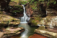 Adams Falls, Ricketts Glen State Park
 -
 Grand View Trail, Ricketts Glen State Park
 -
 Hayfields, Ricketts Glen State Park
 -
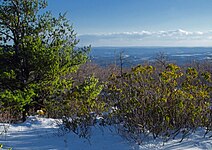
 Summit of Mount Yeager, Nescopeck State Park
_(8213883793).jpg)
.jpg)
.jpg)

Climate

Luzerne County has a humid continental climate (Köppen climate classification Dfa/mostly Dfb) with four distinct seasons. Winters are cold with a January average of 25.8 °F (−3.4 °C).[55] The surrounding mountains have an influence on the climate (which includes both precipitation and temperature). This results in a wide array of weather conditions throughout the county.[56] On average, temperatures below 0 °F (−17.8 °C) are infrequent, occurring three days per year, and there are 36 days where the maximum temperature remains below 32 °F (0.0 °C).[56] In the Wilkes-Barre area, the average annual snowfall is 46.2 inches (117 cm) during the winter (in which severe snowstorms are rare).[56] However, when snowstorms do occur, they can disrupt normal routines for several days.[56]
Summers are warm with a July average of 71.4 °F (21.9 °C).[55] In an average summer, temperatures exceeding 90 °F (32.2 °C) occur on nine days and can occasionally exceed 100 °F (37.8 °C).[57] Spring and fall are unpredictable, with temperatures ranging from cold to warm (although they are usually mild). On average, Wilkes-Barre receives 38.2 inches (970 mm) of precipitation each year, which is relatively evenly distributed throughout the year (though the summer months receive more precipitation).[57]
Extreme temperatures range from −21 °F (−29.4 °C) on January 21, 1994, to 103 °F (39.4 °C) on July 9, 1936.[57] The hardiness zone is 6b in most lower areas except near the Susquehanna and Lackawanna Rivers where it is 7a, and it is 6a in higher areas.[58] Wilkes-Barre averages 2,303 hours of sunshine per year, ranging from a low of 96 hours in December (or 33% of possible sunshine) to 286 hours in July (or 62% of possible sunshine). Despite being at the south end of the county, Hazleton's temperatures average lower than those of the Wyoming Valley due to its elevation.
| Month | Jan | Feb | Mar | Apr | May | Jun | Jul | Aug | Sep | Oct | Nov | Dec | Year |
|---|---|---|---|---|---|---|---|---|---|---|---|---|---|
| Record high °F (°C) | 69 (21) |
76 (24) |
85 (29) |
93 (34) |
93 (34) |
99 (37) |
103 (39) |
102 (39) |
100 (38) |
91 (33) |
81 (27) |
71 (22) |
103 (39) |
| Mean maximum °F (°C) | 57.7 (14.3) |
57.0 (13.9) |
68.0 (20.0) |
81.3 (27.4) |
88.0 (31.1) |
90.5 (32.5) |
92.8 (33.8) |
90.5 (32.5) |
87.6 (30.9) |
78.6 (25.9) |
69.1 (20.6) |
59.6 (15.3) |
94.3 (34.6) |
| Mean daily maximum °F (°C) | 35.7 (2.1) |
38.8 (3.8) |
47.6 (8.7) |
61.1 (16.2) |
72.2 (22.3) |
79.9 (26.6) |
84.6 (29.2) |
82.4 (28.0) |
75.1 (23.9) |
Zdroj:https://en.wikipedia.org?pojem=Luzerne_County||||