

A | B | C | D | E | F | G | H | CH | I | J | K | L | M | N | O | P | Q | R | S | T | U | V | W | X | Y | Z | 0 | 1 | 2 | 3 | 4 | 5 | 6 | 7 | 8 | 9
 Elevated rail near the rebuilt Preston station. | |
| Project overview | |
|---|---|
| Formed | March 2015 |
| Type | Project team |
| Jurisdiction | Melbourne |
| Headquarters | Melbourne |
| Employees | |
| Minister responsible |
|
| Project executive |
|
| Parent department | Department of Transport and Planning |
| Parent authority | Major Transport Infrastructure Authority |
| Website | bigbuild.vic.gov.au |
| ||
|---|---|---|
|
Member of the Legislative Assembly for Mulgrave (2002–2023) Premier of Victoria
Ministries Elections Royal Commissions
|
||

The Level Crossing Removal Project (LXRP) is an infrastructure upgrade program by the Government of Victoria, Australia, to remove and grade-separate 110 level crossings and to rebuild 51 railway stations on the metropolitan and regional rail network of the state capital Melbourne. The project aims to improve network efficiency, rail safety, and reduce traffic congestion.
After pledging the removal of 50 level crossings at the 2014 Victorian state election, the Andrews Government committed $2.4 billion in the 2015–2016 budget to remove the first 20 crossings by 2018. The next 30 crossings were notionally funded through the hypothecation of the sale proceeds from the privatisation of the Port of Melbourne.[1] Prior to the 2018 state election, the government committed to remove a further 25 level crossings, using a new prioritisation framework.[2] In 2021, the government announced a further ten level crossing removals and four level crossing closures would occur by 2025, bringing the total planned level crossing removals to 85 by 2025.[3][4] In 2022, the Andrews government announced the removal of an additional 25 level crossings by 2030, bringing the total to 110.
Previously its own administrative agency, in 2019 the LXRP became a project within the Major Transport Infrastructure Authority, an office of the Victorian Department of Transport and Planning.[5] As of June 2024, 81 crossings have been removed and 42 train stations have been rebuilt as part of the project.[6]
Background
When Melbourne's rail network was built, many road-railway crossings were via level crossing rather than bridges or underpasses due to the city's flat topography and sparse population. As traffic levels increased, these became bottlenecks for road and rail traffic, limiting the speed and frequency of train services. In 1954, the State Government established a committee to look at the removal of level crossings at Clifton Hill, Elsternwick, Footscray, Moorabbin, and Newport.[7][8] These projects were completed by 1960.[9]
In 1983, the level crossing at Station Street, Box Hill, was removed. Other level crossing removals include Dorset Road, Boronia, in 1998 and Middleborough Road, Laburnum, in 2007.[10] In the early 2010s, level crossings were removed at Nunawading (2010), Springvale (2014), Sunshine (2014) and Mitcham (2014).[11][12][13]

As of 2014, there were 176 level crossings left on metropolitan Melbourne's rail network (5 of which were light rail level crossings) and 228 places where railways had been separated from roads;[14] by the end of the Level Crossing Removal Project (LXRP), 66 level crossings will remain.[15] Over two-thirds of these grade separations were constructed between 1863 and 1918, with fewer than one level crossing removal per year between 1918 and 2015. The commitment by the government to remove 110 level crossings over sixteen years, by 2030, represents the fastest rate of crossing removals in Melbourne's history.[16]
History
2014 election commitments

In June 2014, five months prior to the Victorian state election, VicRoads compiled a report of the most dangerous level crossings in Victoria and handed it to the Napthine Liberal-Nationals government.[17] In its 2014 state election manifesto, the then Labor opposition announced that, if elected, it would remove 50 level crossings by grade separation, with 20 to be removed by 2018. Although the majority of crossings announced by Opposition Leader Daniel Andrews were included in the priority list, ten of the crossings highlighted by VicRoads were not on the opposition's list.[18] The sites of all 50 level crossing removals were progressively announced over the following two years after the election of the Andrews government in November 2014.[19]
In September 2016, the Port of Melbourne lease concluded, providing $9.7 billion for infrastructure, including funding for the remaining 30 level crossing removals to be completed by mid-2022.[20]
2018 election commitments

In October 2018, the LXRP surpassed the State Government's 2014 election commitment of removing 20 level crossings by 2018, having officially removed 29 crossings.[21] In the lead up to the 2018 state election, Victorian Premier Daniel Andrews pledged to remove a further 25 level crossings across Melbourne at a cost of $6.6 billion by 2025. The locations of the additional removals were announced progressively over the course of 2018 through a new prioritisation framework based on safety, congestion, and proximity to emergency services.[2]
2021 additional commitments
In July 2021, the State Government announced the removal of an additional ten level crossings and four closures by the end of 2025 at a cost of $2.5 billion.[4] These removals will include the reconstruction of five stations across the network, with stations to be rebuilt at Croydon, Keon Park, Narre Warren, Parkdale, and Ringwood East. At the conclusion of these additional 35 removals, the Pakenham, Cranbourne, and Lilydale lines will have no level crossings for their entire length, with these announcements pushing the number of crossing removals to 85 by 2025.[22]
2022 election commitments
In the lead up to the 2022 state election, the Andrews government announced a further 25 level crossing removals, bringing the total number of removals to 110 by 2030. Many of these removals will be delivered together and include a number of closures. In September 2022, the premier announced eight crossings would be removed in Brunswick on the Upfield line.[23][24] The eight crossings would be removed by 2027 and would include the rebuilding of Jewell, Brunswick, and Anstey stations.[24] The government announced elevated rail would be built along the corridor from Royal Park to Moreland Road, meeting the elevated rail built as part of the 2022 level crossing removal works, and would include an upgrade of the Upfield Bike Path.[23]
In October 2022, the government committed to removing an extra four level crossings on the Ballarat line between Caroline Springs and Melton stations by 2028. Proposed removal methods for the level crossings at Exford Road and Coburns Road is by constructing a rail trench (since revised to a rail bridge) and lowering Melton station, while the roads will be elevated over tracks to get rid of the Hopkins Road and Ferris Road level crossings.[25] Seven more crossing removals and two closures were announced in October 2022 for the Frankston line.[26] These level crossings would be removed by 2029 and would make the line level crossing free for its entire length.[26] Four stations will be rebuilt as part of the removals at Highett, Mordialloc, Aspendale and Seaford.[27]
On 21 and 25 October 2022, the Andrews government announced an additional two level crossing removals for the Sunbury line and one on the Hurstbridge line. These crossings are located at Old Calder Highway and Watsons Road, Diggers Rest, and Ruthven St, Macleod. These crossings will be removed by 2026 via the construction of a road bridge for the Sunbury line removals and a rail bridge for the Hurstbridge line.[28] At the conclusion of these removals, the Sunbury line will be fully level crossing free.[29]
The government announced an additional three removals and two closures on the Werribee line on 27 October 2022.[30][31] Along with the four already removed on the Werribee line, these removals would make the line level crossing free by 2030, and allow for additional services and the construction of the Geelong Fast Rail project.[31] The crossings at Hudsons Road, Spotswood, Maddox Road, Newport, and Maidstone Street, Altona. These crossings will be removed with a combination of rail over and road over, and will include a newly elevated Spotswood station.[32] The crossings at Anderson Street, Yarraville, and Champion Road, Newport will be closed during the project. Pedestrian links will still remain with a plan to upgrade local roads to accommodate the closure of these crossings.[32]
Governance

The Level Crossing Removal Authority (LXRA) was formed in May 2015 as an administrative office of the then-new Department of Economic Development, Jobs, Transport and Resources to deliver the project.[33][34][35]
Later, the LXRA led delivery of other rail projects, including extension of the South Morang line to Mernda, upgrades of the Hurstbridge and Cranbourne lines, as well as a rebuilt Frankston station. The authority also delivered a new stabling facility north of Wyndham Vale station and train storage at Kananook.[36][37]
The LXRA was abolished as an independent administrative office following the 2018 state election, and its functions were absorbed into the newly formed Major Transport Infrastructure Authority at the Department of Transport.[38]
Architecture and urban design

The LXRP has used several different design approaches to removing level crossings, tailoring designs to different urban settings around Melbourne.[39] Most projects, particularly those in the denser inner- and middle-suburbs, have involved lowering the rail line into a trench or elevating the rail line above the road. Some projects in outer suburbs, such as Gap Road near Sunbury station or Station Street near Beaconsfield station, have involved lowering or raising the road without altering the existing rail corridor. This is enabled by the additional space surrounding the railway line.[39]
As noted by University of Melbourne researchers in 2016, the scale of the project had significant urban renewal implications for the city:
Each crossing removal affects, on average, at least a kilometre of rail corridor and, within the urban area, this usually includes a station. In some instances, topography has required the removal of more than one crossing to meet rail engineering requirements as well as longer sections of corridor becoming part of the works. On the face of it, this means that the current seventy-five crossing removals could result in seventy-five kilometres of transformed rail corridors and fifty-seven new stations – more than a quarter of Melbourne’s total.[39]
The researchers emphasised the urban benefits from new elevated rail over trenched rail, including the creation of new parkland and open space, arguing wider benefits could be achieved beyond reducing traffic congestion.[40] One study examined the local public health positive and negative impacts from the removal of level crossings on the Upfield line, including significant construction impacts.[41] The study found that by improving road connections the project could help induce more car usage, but that this could be offset by improving pedestrian and cycling connections.[42]
- Architecture of the Level Crossing Removal Project
-
 Moreland railway station shows the integration of the heritage station into the new elevated design.
 -
 Entrance of newly elevated Coburg railway station.
 -
 Newly elevated Reservoir railway station.
 -
 Bonbeach railway station displays the project's sunken station designs.
.jpg)
.jpg)


Awards
The LXRP has received numerous awards for their different projects in the categories of sustainability, architecture, and urban design. The Reservoir station project was presented the 'Special Prize Exterior' award in the Passenger Stations category at the World Architecture and Design Award at the 2021 Prix Versailles.[43][44] The Toorak Road level crossing removal topped the infrastructure category of the Australian Institute of Landscape Architects awards due to the design of the new public parkland, cycling paths, and open space.[45] The elevated rail project from Moreland to Coburg stations saw landscape architects Tract win the Infrastructure Award of Excellence for their landscape and urban design work on the project, with the judging panel "particularly impressed with the urban renewal of the area".[45][46] The Bell to Moreland project was also awarded a score of 98 points from the Infrastructure Sustainability Council (ISC), the highest rating ever awarded in Australia.[47]
Elevated rail

Some of the most significant changes to Melbourne's urban structure from the LXRP have resulted from the construction of large sections of elevated rail, something that was relatively rare in Melbourne.[48] In 2016, the government announced that 8.3 kilometres (5.2 mi) of elevated rail would be built in Melbourne's south-eastern suburbs to remove nine level crossings on the Pakenham and Cranbourne rail corridor and build five new elevated stations at Carnegie, Murrumbeena, Hughesdale, Clayton and Noble Park.[48]
Dubbed "sky rail" by opponents and some media outlets, the LXRP spurred significant local opposition due to concerns over visual and noise impacts, and lack of consultation.[49][50] The project became a political issue in the 2018 state election, although one opinion poll commissioned by The Age newspaper found 60% of Victorians supported the use of elevated rail to remove level crossings, and the government was returned at the election with an increased majority.[51][52] Prior to the election, the government announced more sections of elevated rail on the Pakenham line.[53]
Some experts argued elevated rail offered a better urban outcome than trenched rail, providing opportunities for more open space, economic development, better local connections and less disruption from construction.[49][54] The Caulfield to Dandenong level crossing removals created a large new section of open parkland, dubbed a "linear park".[39] This included 22.5 hectares (56 acres) of new open space, sports courts, playgrounds, new walking and cycling trails, and expanded station forecourts.[55][56] As part of the project, the Djerring Trail was created, a 17-kilometre (11 mi) shared-use path along the rail corridor. In the year after the elevated rail opened in 2018, the media reported that many residents, including some who were opposed to the project, were happy with the outcome and utilised the new open space.[57][58]
Tree removal

The removal of mature trees for level crossing removal works has been a source of controversy with some local residents and project critics.[59][60] Due to the nature of the LXRP, trees need to be cut down or relocated from the site to allow for construction works. This is a particular issue for projects where the rail line is lowered into a trench, such as the planned level crossing removals near Glen Huntly station, which have required significant mature tree removal along the planned one-kilometre (0.6 mi) rail trench.[61][62] An elevated rail design was chosen to remove the level crossings near Rosanna station in part to minimise the loss of native trees, as a proposed rail trench would have required the removal of hundreds of mature river red gum trees along the corridor.[63][64]
According to a newspaper report, more than 10,000 trees have been cut down since 2014 to allow for the construction of Victorian infrastructure projects—including hundreds of trees for the LXRP.[59] During the level crossing removal at Moreland Road, a campaign against the removal of 100 mature trees was unsuccessful, with a local councillor claiming only three or four trees remained at the conclusion of the project.[59] In response, the government has stated more trees were planted than were there originally, as part of expanded parkland at the site.[59] The state opposition has highlighted and campaigned on tree loss due to major infrastructure projects.[59]
Railway heritage

The loss of heritage railways stations and the impact on heritage architecture has been a source of controversy and a key design consideration for the project. During the removal of a level crossing or rebuild of a railway station, heritage station buildings or existing railway infrastructure may be impacted. Some heritage buildings have been demolished, while others have been retained, moved or adapted for other uses, such as at Clayton and Mentone stations.[65][66]
At the Warrigal Road level crossing removal, Kingston Council have called for heritage protection for the heritage Parkdale railway station buildings.[67] This request has been denied by the Department of Environment, Land, Water and Planning as well as Heritage Victoria on grounds that the structure is "not of state-level cultural heritage significance".[68] Nonetheless, in response to the local campaign to preserve the original heritage station building, the LXRP announced it would retain and repurpose the building within the precinct, although the extent of the retention is not clear.[69][70]
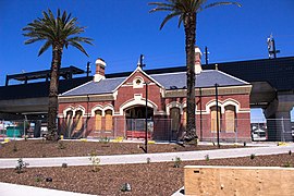
Other crossing removals have had their heritage structures restored for reuse. At Moreland station, the original heritage station building that opened in 1884 was restored and turned into additional station facilities.[71] Heritage restorations are common across the removals, with other examples including the signals box at Gardiner railway station turning into bike parking, and the station building at North Williamstown railway station being restored into community and station facilities.[72][73]
Crossing closures
The use of road closures to remove level crossings has been a source of controversy. The government has used crossing closures in select cases where there are nearby crossing removal projects or existing grade-separated major roads. For example, the crossings at Anderson Street, Yarraville, and Champion Road, Newport will be closed at the same time as the rail line will be elevated above Hudsons Road in nearby Spotswood and at Maddox Road in Newport with new grade-separated pedestrian and cycling crossings also built.[32] According to the government, this solution is required is due to the constrained site, significant heritage impacts that would arise from grade separation, and the relatively low level of car traffic on the roads.[32] Some local residents, however, have objected to the road closures, arguing there would be significant impacts to local car journeys.[74] Similar objections were raised during the 2022 state election by the state opposition over the closure of Latrobe Street in Cheltenham, which similarly is located close to two other grade separated crossings completed in 2020.[75]
New and amalgamated stations

Due to a large portion of level crossings also having adjacently located stations, many stations have been rebuilt as part of the project. Rebuilt stations have subsequently delivered improve facilities for passengers, including new toilet facilities, drinking fountains, increased levels of accessibility, better integration with surrounding transport connections, and higher quality architectural designs, amongst other benefits.[76]
Whilst the majority of stations demolished as part of the project have been rebuilt and reopened, a few projects have resulted in the amalgamation of stations. Whilst controversial, these instances have usually only occurred due to the close proximity between existing stations, reducing the negative impact on users. Amalgamated stations have allowed for improved station locations, faster journey times, and higher quality facilities.[77] One amalgamation has included Mont Albert and Surrey Hills stations on the Belgrave and Lilydale lines. In 2023, these two stations were closed and amalgamated into the new Union station located in-between the two former locations as part of the removals of Mont Albert and Union roads project.[78] This amalgamation has received criticism, with opponents highlighting how the increased distances from the two shopping centres on Union Road and Hamilton Street will negatively impact local mobility.[79] Despite communicty critism, this project was completed in 2023 with the removal of two level crossings and the opening of the new Union station.[80]
Reception
Political

The LXRP has generally been seen as a political success for the Andrews government. Journalist Benita Kolovos argued it was the quick rollout of the program and the visible, tangible benefits it delivered to communities that drove its electoral success.[81] She wrote: "It was promised at the 2014 election, construction began in the first year of the Andrews government’s term and several were completed before the 2018 election. Commuters benefited from more trains, drivers from less traffic."[81] The government's messaging on the project has focused on these localised benefits, public safety, and the prevalence of level crossings within Melbourne. Minister for Transport Infrastructure Jacinta Allan said in 2021: "Every Victorian knows the dinging sound of boom gates coming down and the frustration that comes with it, that’s why we’re getting rid of them – saving lives, easing congestion and getting you home sooner."[82]
But controversy over design choices and the cost of the project has also prompted opposition. Liberal MP Brad Rowswell criticised the Andrews government for a lack of community consultation and local feedback on the project and claimed that the government was out of touch with the community.[75] Shadow Minister for Transport Infrastructure David Davis criticised the project for its cost, arguing that “without a comprehensive business case, there is simply no proper economic justification for the Level Crossing Removal Program".[83] The ongoing disruption of roadworks for the project was also an issue in some suburbs.[84]
Media
The Guardian Australia has called the program "transformational" and "suburb moulding" in comments about the Andrews government's infrastructure projects.[85] Other local newspapers, such as The Age and Herald Sun, have been critical of the project and have highlighted local opposition in their reporting.[86][87][88][89]
Experts and lobby groups
The Public Transport Users Association has campaigned for level-crossing removals, and has welcome the LXRP and its benefits to the public transport system, with spokesman Daniel Bowen highlighting how the projects "bring a lot of pluses to the wider community, and it’s good to finally see progress on them."[90][91] The Royal Automobile Club of Victoria have also campaigned for level crossing removals, and have welcomed announcements of crossing removals.[92]
Academics Ian Woodcock and John Stone have highlighted the benefits from the LXRP, including its urban design opportunities and how it has contributed to the revitalisation of public transportation in Melbourne.[93][39] Other academics such as Monash University researcher Graham Currie have been critical of the project, arguing the travel time savings resulting from the project were low and did not justify the cost.[88]
Auditor-General

A report released in December 2017 by the Victorian Auditor-General's Office in the LXRP's original fifty level crossing removals found that the speed and cost of the project carried significant risks.[94] The report criticised the Level Crossing Removal Authority for its haste in delivering the program, and found that the rapid pace of the project had contributed to a failure to properly assess the merits of each grade separation. In 2017, the project's cost was found to have increased to $8.3 billion, the project is more than 38% more expensive than its initial $5–6 billion estimated price tag.[94]
The Auditor-General criticised the selection of crossings, stating that the value of the project was compromised by the apparent political motivation for some crossing removals at the expense of more dangerous or congested intersections.[95] In their report, the Auditor-General found that only 32 of the crossings chosen in the original 50 removals were featured in the top 50 of a 2008 list by the Department of Transport of the state's most dangerous level crossings. 28 of these were prioritised on a 2013 VicRoads removal list which was handed to the Napthine government.[94]
Since these findings, the LXRP has developed and applied a transparent process to select sites for the additional level crossing removals. In a follow-up 2020 report, the Auditor-General stated the new process has improved the project’s cost-effectiveness because it uses delivery efficiency as one of the criteria for site selection.[96] The Auditor-General noted the Department and the Major Transport Infrastructure Authority had fully addressed seven of its recommendations, partially addressed one and was working to address two more, but warned that the project had not completed a business case for its second batch of crossing removals so the economic benefits were unclear.[96]
Public
While the LXRP has been broadly popular, local opposition has attracted significant media attention. Elevated rail has been controversial among some local residents and businesses, with protests over the removal of crossings on the Upfield line calling for a rail trench to be used instead.[97][98] At the same time, polling has found a majority of Victorians supported the use of elevated rail to remove level crossings.[51] In other examples, such as the Caulfield to Dandenong elevated rail project, local media reported that many residents were supportive of the project's outcomes.[57][58]
List of crossing removals
Original 50 crossing removals: 2014–2022edit
Prior to the 2014 state election, the then Labor opposition announced a plan to remove 50 level crossings by 2022, including 20 by 2018.[99] Park Road, Cheltenham, Mascot Avenue, Bonbeach, and Lochiel Avenue, Edithvale were added to the original 50 level crossing removals after further community consultations.[100][101][102] This pushed the number of level crossing removals to 53. These removals were completed on the Glen Waverley, Frankston, Sunbury, Belgrave, Lilydale, Upfield, Pakenham, Cranbourne, Werribee, Craigieburn, and Mernda lines by May 2022.[103]
| Line(s) | Road | Nearest station | Solution | Date of completion | |
|---|---|---|---|---|---|
| Glen Waverley | Burke Road | Gardiner | Rail under | January 2016[104] | |
| Frankston | Centre Road | Bentleigh | Rail under | August 2016[105] | |
| Frankston | McKinnon Road | McKinnon | Rail under | August 2016[106] | |
| Frankston | North Road | Ormond | Rail under | August 2016[107] | |
| Sunbury | Furlong Road | Ginifer | Rail under | November 2016[108] | |
| Sunbury | Main Road | St Albans | Rail under | November 2016[109] | |
| Belgrave | Mountain Highway | Bayswater | Hybrid | December 2016[110] | |
| Belgrave | Scoresby Road | Bayswater | Rail under | December 2016[111] | |
| Belgrave, Lilydale | Blackburn Road | Blackburn | Rail under | January 2017[112] | |
| Belgrave, Lilydale | Heatherdale Road | Heatherdale | Rail under | January 2017[113] | |
| Upfield | Camp Road | Gowrie | Rail under | December 2017[114] | |
| Sunbury | Melton Highway | Watergardens | Road over | January 2018[115] | |
| Cranbourne, Pakenham | Chandler Road | Noble Park | Rail over | February 2018[116] | |
| Cranbourne, Pakenham | Corrigan Road | Noble Park | Rail over | February 2018[117] | |
| Cranbourne, Pakenham | Heatherton Road | Noble Park | Rail over | February 2018[118] | |
| Cranbourne, Pakenham | Centre Road | Clayton | Rail over | April 2018[119] | |
| Cranbourne, Pakenham | Clayton Road | Clayton | Rail over | April 2018[120] | |
| Hurstbridge | Grange Road | Alphington | Rail under | May 2018[121] | |
| Hurstbridge | Lower Plenty Road | Rosanna | Rail over | May 2018[122] | |
| Cranbourne, Pakenham | Grange Road | Carnegie | Rail over | June 2018[123] | |
| Cranbourne, Pakenham | Koornang Road | Carnegie | Rail over | June 2018[124] | |
| Cranbourne, Pakenham | Murrumbeena Road | Murrumbeena | Rail over | June 2018[125] | |
| Cranbourne, Pakenham | Poath Road | Hughesdale | Rail over | June 2018[126] | |
| Frankston | Skye/Overton Road | Kananook | Rail over | June 2018[127] | |