

A | B | C | D | E | F | G | H | CH | I | J | K | L | M | N | O | P | Q | R | S | T | U | V | W | X | Y | Z | 0 | 1 | 2 | 3 | 4 | 5 | 6 | 7 | 8 | 9
| Puerto Rico Highway System | |
|---|---|
Highway shields for primary, urban primary, secondary and tertiary sections of PR-1 | |
| Highway names | |
| Interstates | Interstate PRnn (PRI-nn) (unsigned) |
| Commonwealth: | Puerto Rico Highway nn (PR-nn) |
| System links | |


The highway system in Puerto Rico is composed of approximately 14,400 kilometers (8,900 mi)[1] of roads in Puerto Rico, maintained by the Puerto Rico Department of Transportation and Public Works (Spanish: Departmento de Transportación y Obras Públicas) or DTOP. The highway system in Puerto Rico is divided into four networks: primary, urban primary, secondary or inter-municipal, and tertiary or local (Spanish: red primaria, red primaria urbana, red secundaria o intermunicipal, and red terciaria o local).[1] Highways may change between networks and retain their same numbers.
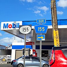
Highway markers
Puerto Rico roads are classified according to the network they belong to. There are four types: primary, urban primary, secondary, and tertiary.[1][2]
In this regard, a primary road is one which is part of the primary network, an urban primary road is part of the urban primary network, etc. Generally, the same highway may change between networks, but the highway will continue to have the same number. For example, PR-1, connecting Ponce and San Juan, is signed as urban primary inside the Ponce city limits, then it is signed as secondary in Ponce's rural barrio Capitanejo, and then it is again signed as urban primary on its entry into the town of Santa Isabel.
Primary roads are numbered 1 through 99, secondary roads are numbered 100 to 299, and tertiary roads are numbered 300 to 9999.[3] In 2009, primary routes comprise about 14% of the total Commonwealth system mileage, secondary about 30%, and tertiary (municipal) about 56% of the total mileage.[3]
-
 Route number markers on PR-191 in 2009; on the left is the tertiary highway marker, in the middle is a Forest Highway marker, and on the right is a pre-1999 marker.
 -
 An example of route transition between networks


| Highway network | Highway marker for Route 1 |
Purpose[1] | Route numbers[3] |
|---|---|---|---|
| Primary roads | Facilitate movement of passengers and freight between major regions in the Island (north, south, east, west) | 1–99[a] | |
| Urban primary roads | Complement the primary network inside a metro area (San Juan, Ponce, Mayagüez, Arecibo, Aguadilla, Humacao, Caguas and Guayama) | Any (1–9999) | |
| Secondary (or inter-municipal) roads | Provide access to municipalities from primary network roads | 100–299[a] | |
| Tertiary (or intra-municipal) roads | Provide access to a municipality's main urban area from peripheral communities | 300–9999 |
- ^ a b Just as some highways numbered 1–99 may have secondary or tertiary network type markers on specific segments of their roadways, some highways numbered 100–299 may also have tertiary network markers—black numbers on white circles set against a black square—in specific segments of those highways, to indicate that such portions of the highway are part of the tertiary network.
Less common markers

.svg)
At least two[1] other markers can be observed in Puerto Rico roads today (2019). The first is the older style road marker which, above the route number, also had the outline of the main island of Puerto Rico with the words Puerto Rico on the outline as shown here. Until 1999,[4] all non-tolled numbered highways in Puerto Rico had the same route marker, a square with a white-on-black half-circle with the route number in the bottom two thirds and a map of Puerto Rico with the words Puerto Rico written inside in the top third. A second road marker, used on the road through El Yunque National Forest, is the brown-colored upside-down trapezoidal marker with the road number on the top two-thirds of the sign and the words Bosque Nacional (national forest) on the bottom one-third, as shown.
Roadway maintenance
All Puerto Rico Highway System roads, regardless of the classification used, are maintained by the centralized, Commonwealth-level, Departmento de Transportación y Obras Públicas (DTOP). Municipal governments are not responsible for maintenance of the Puerto Rico Highway System roads within their territory; whether or not the municipal government is an autonomous government, DTOP is the responsible agency.[5] The DTOP maintains a network of regional offices throughout the island which carry out DTOP work within their multi-municipality region. Municipal governments are only responsible for maintenance of city and town streets within their jurisdictions.[6] On occasion, the central government has entered into memoranda of agreement with municipal governments for the collaborative maintenance of some Puerto Rico Highway System roadways within their municipalities.[7][8]
Municipal roads
In Puerto Rico, the term municipal road may be encountered occasionally. This is not a “fourth” network of State roads. Roadways that have both their terminus within the same municipality are called tertiary roads and are, by convention, numbered PR-300 through PR-9999. Tertiary roads are also sometimes called Carreteras de la red local (English: Local network roads).[2]
However, the term municipal road or municipal highway (Spanish: Carretera municipal) refers to any public roadway that is not marked with a Puerto Rico road marker.[9] Roadways marked with a Puerto Rico road marker are those public roadways that include PR followed by a number in its markers. Such roads are considered State roads and part of the Puerto Rico Highway System. Public roadways that do not include such markings are termed municipal roadways. Unlike State roads, which are signed with numbers, municipal roads are signed with names, such as Calle Hostos, Calle De Diego, Calle San Jorge, Calle León M. Acuña.[9]
Tertiary roads are not municipal roads even though at times the term municipal road has been used (as a shortcut to intra-municipal road)—even by the Government of Puerto Rico—to refer to a tertiary State road.[3] The confusion comes from the context in which the phrase municipal road occurs. When the term municipal road occurs in the context of roads owned and maintained by the State government, municipal roads means tertiary State network roads. In this context, a municipal road and a State tertiary road both refer to the same network of State roads. However, if the term occurs in the context of roadways owned and maintained by a municipal government, it refers to the network of local streets and roadways that make up the urban landscape of a municipality.
Another context sometimes encountered is the context of how a road is used, that is, the purpose of a road. The purpose of a road is indicative of whether a road is a municipal road or not. In its strictest meaning, the term municipal roads refers to roads within a municipality's urban center that provide access from one urban neighborhood to another urban neighborhood within the same urban area (city, town, poblado, etc.), while in the larger context of the State highway system, municipal roads refers to roads that “provide access to the main urban area of a municipality from peripheral communities” (that is, tertiary roads).[1] Municipal roads are maintained by the municipal government where those roads occur, while tertiary roads are maintained by the State government. As stated under the section Road maintenance, at times the State government has entered into Memorandums of Agreement with municipal governments for the upkeep of a State tertiary roadway (note this is a State-owned road that runs entirely within a single municipality), but this does not make it a municipal road—the road continues to maintain its State signage and ownership.[7][8]
Expressways
Highways with control access fall into three types: An expressway is an arterial highway with full or partial control of access. Expressways with full control of access are termed freeways. If the freeway charges a toll for its use, it is called an autopista.[3] Most tollbooths accept the AutoExpreso, an electronic toll collection system, to avoid traffic congestion.[10][11] Toll roads between San Juan and Arecibo, and between San Juan and Ponce were envisioned by J. Raymond Watson, a Puerto Rican engineer, in 1970.[12]
All Puerto Rico expressways are signed either as primary or as urban primary routes.
.jpg)


| Route | Name | Terminus | Maximum speed limit | Notes |
|---|---|---|---|---|
| PR-2 | Expreso Kennedy | Starts from San Patricio Plaza (Guaynabo) to Santurce (San Juan, aka Parada 18). | 50 mph (80 km/h) | Guaynabo to San Juan section only. |
| PR-2 | Roberto Sánchez Vilella | Starts from Mayagüez Mall (Mayagüez) to PR-1 in Ponce | 55 mph (90 km/h) | Mostly converted to expressway from Mayagüez Mall to Ponce. |
| PR-5 | Expreso Río Hondo | Bayamón, PR-22 to Naranjito, PR-147 and PR-149 with discontinuity between PR-199 in Bayamón and PR-167 in Toa Alta. | 50 mph (80 km/h) | Tolled. This road has three expressway segments as of April 2012—these are between PR-29 and PR-22 and between PR-2 and PR-199 (both in Bayamón), an unbuilt portion in southern Bayamón and a portion between PR-167 (Toa Alta) and the town of Naranjito. |
| PR-9 | Baldorioty de Castro | PR-10 Barrio Portugués to PR-2 Barrio El Tuque | 55 miles per hour (89 km/h) to 65 miles per hour (105 km/h) | From PR-123 to PR-2 still under construction |
| PR-12 | Santiago de los Caballeros | PR-14 Barrio Machuelo Abajo to PR-123 Barrio Playa | 55 miles per hour (89 km/h) | |
| PR-18 | Expreso Las Américas | PR-22 San Juan and PR-52 San Juan | 55 to 65 mph (90 to 110 km/h) | |
| PR-20 | Expreso Rafael Martínez Nadal | PR-2 in the San Patricio area in Guaynabo to PR-1 in La Muda sector in Caguas | 55 mph (90 km/h) | Tolled |
| PR-22 | Autopista José de Diego | Hatillo, PR-2 to San Juan, PR-26 | 65 mph (105 km/h) | Extension to Aguadilla in planning. Tolled |
| PR-26 | Expreso Román Baldorioty de Castro | San Antonio Bridge (Bridge to Old San Juan Island) to PR-3 in Carolina. | 65 mph (105 km/h) | |
| PR-30 | Expreso Cruz Ortiz Stella | Caguas, PR-1 to Humacao, PR-53 | 55 mph (90 km/h) | |
| PR-52 | Autopista Luis A. Ferré | Ponce, PR-2 to San Juan, PR-1 and PR-18 | 65 mph (105 km/h) | Tolled. This highway is the longest tolled freeway in Puerto Rico. |
| PR-53 | Autopista Dr. José Celso Barbosa | Fajardo through Ceiba to Yabucoa, and then Guayama to Salinas. | 65 mph (105 km/h) | Maunabo tunnels constructed in October 2008. The segments between Yabucoa and Maunabo still incomplete. |
| PR-60 | Avenida Dionisio Casillas | Humacao, PR-30 to Humacao, PR-3 | 55 mph (90 km/h) | |
| PR-66 | Autopista Roberto Sánchez Vilella | PR-3 in Carolina and Río Grande | 65 mph (105 km/h) | Second half opened in October 2012 to Río Grande. Tolled. |
| PR-165 | Expreso El Caño | Guaynabo, PR-2 and PR-23 to Cataño | 50 mph (80 km/h) |
List of highways
Below is a list of some highways in Puerto Rico along with the municipalities where they begin and end.
Primary highways
Primary roads are numbered in the 1 to 99 range and are distributed randomly throughout the island.
| Number | Length (mi) | Length (km) | Southern or western terminus | Northern or eastern terminus | Formed | Removed | Notes |
|---|---|---|---|---|---|---|---|
| 79.6 | 128.1 | PR-123 in Ponce | Calle Tanca in San Juan | — | — | Carretera Central | |
| 143.0 | 230.1 | PR-1 / PR-133 in Ponce | PR-26 in San Juan | — | — | ||
| 0.5 | 0.80 | PR-440 in Aguadilla | PR-2 in Aguadilla | — | — | Aguadilla business spur | |
| — | — | PR-2 / PR-114 in Mayagüez | PR-2 in Mayagüez | — | — | Mayagüez business loop; renumbered to PR-239[13] | |
| 1.01[14] | 1.63 | PR-2 / PR-5549 in Ponce | PR-123 in Ponce | — | — | Ponce business spur; formerly PR-2 | |
| 99.9 | 160.8 | PR-1 in Salinas | PR-1 in San Juan | — | — | ||
| 0.87 | 1.40 | PR-3 in Humacao | PR-3 in Humacao | — | — | Humacao business loop | |
| — | — | PR-17 in San Juan | PR-26 in Carolina | — | — | Became part of PR-8 | |
| — | — | PR-114 in Hormigueros | PR-102 in San Germán | — | — | Renumbered to PR-103 and PR-101[15] | |
| 16.0 | 25.7 | PR-152 / PR-164 in Naranjito | Calle Canal in Cataño | — | — | Tolled in Bayamón. Exists in two segments due to an unconstructed portion in Bayamón. | |
| — | — | PR-2 in Aguadilla | PR-2 in Aguadilla | 1953[16] | — | Renumbered to PR-107 and PR-110[16] | |
| 1.1 | 1.8 | PR-2 in Bayamón | PR-5 in Bayamón | — | — | Formerly PR-21 | |
| 2.5 | 4.0 | PR-17 in San Juan | PR-3 in San Juan | — | — | Formerly PR-4 | |
| 4.52[17] | 7.27 | PR-2 / PR-52 in Ponce | PR-10 in Ponce | — | — | Exists in two portions, as the portion between PR-123 and PR-500 is actually under construction. | |
| 42.42[18] | 68.27 | PR-5506 in Ponce | PR-2 in Arecibo | — | — | Exists in two segments due to a still-under-construction portion between Adjuntas and Utuado. Much of old route now PR-123; the current alignment dates from 1974. | |
| 3.28[19] | 5.28 | Port of Ponce | PR-14 in Ponce | 1960[20][a] | current | ||
| 45.4 | 73.1 | PR-123 / PR-123P in Ponce | PR-1 in Cayey | — | — | Carretera Central | |
| 0.56 | 0.90 | PR-123 / PR-123P in Ponce | PR-14 / PR-14P in Ponce | — | — | Ponce business spur | |
| 16.03 | 25.80 | PR-3 in Guayama | PR-14 in Cayey | 1953[21] | current | Part of the Ruta Panorámica | |
| 0.53 | 0.85 | Calle Miraflores in San Juan | PR-1 / PR-26 in San Juan | — | — | ||
| 7.1 | 11.4 | PR-19 in San Juan | PR-26 in Carolina | — | — | Tolled at the Teodoro Moscoso Bridge. | |
| 3.78[19] | 6.08 | PR-1 / PR-52 in San Juan | PR-22 in San Juan | — | — | ||
| 1.2 | 1.9 | PR-21 in San Juan | PR-2 in Guaynabo | — | — | PR-19 is the main avenue in San Patricio, Guaynabo. | |
| 6.03[19] | 9.70 | PR-1 in Guaynabo | PR-2 in Guaynabo | — | — | Tolled | |
| 3.1 | 5.0 | PR-19 in San Juan | PR-1 / PR-176 in San Juan | — | — | ||
| 52.01[19] | 83.70 | PR-2 in Hatillo | PR-26 in San Juan | 1969[22] | current | Tolled; portion of unsigned Interstate PRI-2 | |
| 4.0 | 6.4 | PR-2 / PR-165 in Guaynabo | Zdroj:https://en.wikipedia.org?pojem=Interstate_PR1