

A | B | C | D | E | F | G | H | CH | I | J | K | L | M | N | O | P | Q | R | S | T | U | V | W | X | Y | Z | 0 | 1 | 2 | 3 | 4 | 5 | 6 | 7 | 8 | 9
Houston | |
|---|---|
City | |
| Nickname(s): Space City (official), more ... | |
 Interactive map of Houston | |
 Houston Location in Texas  Houston Location in the United States | |
| Coordinates: 29°45′46″N 95°22′59″W / 29.76278°N 95.38306°W | |
| Country | United States |
| State | Texas |
| Counties | Harris, Fort Bend, Montgomery |
| Incorporated | June 5, 1837 |
| Named for | Sam Houston |
| Government | |
| • Type | Strong Mayor-Council |
| • Body | Houston City Council |
| • Mayor | John Whitmire (D) |
| Area | |
| • City | 671.67 sq mi (1,740 km2) |
| • Land | 640.44 sq mi (1,658.73 km2) |
| • Water | 31.23 sq mi (80.89 km2) |
| Elevation | 80 ft (32 m) |
| Population | |
| • City | 2,301,572 |
| • Estimate (2022)[2] | 2,302,878 |
| • Rank | 7th in North America 4th in the United States 1st in Texas |
| • Density | 3,598.43/sq mi (1,389.36/km2) |
| • Urban | 5,853,575 (US: 5th) |
| • Urban density | 3,339.8/sq mi (1,289.5/km2) |
| • Metro | 7,122,240 (US: 5th) |
| Demonym | Houstonian |
| GDP | |
| • Greater Houston | $633.2 billion (2022) |
| Time zone | UTC−6 (CST) |
| • Summer (DST) | UTC−5 (CDT) |
| ZIP Codes | 770xx, 772xx (P.O. Boxes) |
| Area codes | 713, 281, 832, 346 |
| FIPS code | 48-35000[6] |
| GNIS feature ID | 1380948[7] |
| Website | www |


.jpg)


Houston (/ˈhjuːstən/ ⓘ; HEW-stən) is the most populous city in the U.S. state of Texas and in the Southern United States. Located in Southeast Texas near Galveston Bay and the Gulf of Mexico, it is the seat and largest city of Harris County; as well as the principal city of the Greater Houston metropolitan area, which is the fifth-most populous metropolitan statistical area in the United States and the second-most populous in Texas after Dallas–Fort Worth. With a population of 2,302,878 in 2022,[2] Houston is the fourth-most populous city in the United States after New York City, Los Angeles, and Chicago, and the seventh-most populous city in North America. Houston is the southeast anchor of the greater megaregion known as the Texas Triangle.[8]
Comprising a land area of 640.4 square miles (1,659 km2),[9] Houston is the ninth-most expansive city in the United States (including consolidated city-counties). It is the largest city in the United States by total area whose government is not consolidated with a county, parish, or borough. Though primarily in Harris County, small portions of the city extend into Fort Bend and Montgomery counties, bordering other principal communities of Greater Houston such as Sugar Land and The Woodlands.
Houston was founded by land investors on August 30, 1836,[10] at the confluence of Buffalo Bayou and White Oak Bayou (a point now known as Allen's Landing) and incorporated as a city on June 5, 1837.[11][12] The city is named after former General Sam Houston, who was president of the Republic of Texas and had won Texas's independence from Mexico at the Battle of San Jacinto 25 miles (40 km) east of Allen's Landing.[12] After briefly serving as the capital of the Texas Republic in the late 1830s, Houston grew steadily into a regional trading center for the remainder of the 19th century.[13]
The arrival of the 20th century brought a convergence of economic factors that fueled rapid growth in Houston, including a burgeoning port and railroad industry, the decline of Galveston as Texas's primary port following a devastating 1900 hurricane, the subsequent construction of the Houston Ship Channel, and the Texas oil boom.[13] In the mid-20th century, Houston's economy diversified, as it became home to the Texas Medical Center—the world's largest concentration of healthcare and research institutions—and NASA's Johnson Space Center, home to the Mission Control Center.
Since the late 19th century Houston's economy has had a broad industrial base, in energy, manufacturing, aeronautics, and transportation. Leading in healthcare sectors and building oilfield equipment, Houston has the second-most Fortune 500 headquarters of any U.S. municipality within its city limits (after New York City).[14][15] The Port of Houston ranks first in the United States in international waterborne tonnage handled and second in total cargo tonnage handled.[16]
Nicknamed the "Bayou City", "Space City", "H-Town", and "the 713", Houston has become a global city, with strengths in culture, medicine, and research. The city's population comprises various ethnic and religious backgrounds, as well as a large and growing international community. Houston is the most diverse metropolitan area in Texas and has been described as the most racially and ethnically diverse major city in the U.S.[17] It is home to many cultural institutions and exhibits, such as the Houston Museum District and the Houston Theater District.[18]
History
Present-day Houston sits on land that was once occupied by the Karankawa and the Atakapa indigenous peoples for at least 2,000 years before the first known settlers arrived.[19][20][21] These tribes are almost nonexistent today; this was most likely caused by foreign disease, and competition with various settler groups in the 18th and 19th centuries.[22] However, the land then remained largely uninhabited from the late 1700s until settlement in the 1830s.[23]
Early settlement to the 20th century
The Allen brothers—Augustus Chapman and John Kirby—explored town sites on Buffalo Bayou and Galveston Bay. According to historian David McComb, "he brothers, on August 26, 1836, bought from Elizabeth E. Parrott, wife of T.F.L. Parrott and widow of John Austin, the south half of the lower league granted to her by her late husband. They paid $5,000 total, but only $1,000 of this in cash; notes made up the remainder."[24]
The Allen brothers ran their first advertisement for Houston just four days later in the Telegraph and Texas Register, naming the notional town in honor of Sam Houston, who would become President later that year.[12] They successfully lobbied the Republic of Texas Congress to designate Houston as the temporary capital, agreeing to provide the new government with a state capitol building.[25] About a dozen persons resided in the town at the beginning of 1837, but that number grew to about 1,500 by the time the Texas Congress convened in Houston for the first time that May.[12] The Republic of Texas granted Houston incorporation on June 5, 1837, as James S. Holman became its first mayor.[12] In the same year, Houston became the county seat of Harrisburg County (now Harris County).[26]
In 1839, the Republic of Texas relocated its capital to Austin. The town suffered another setback that year when a yellow fever epidemic claimed about one life for every eight residents, yet it persisted as a commercial center, forming a symbiosis with its Gulf Coast port, Galveston. Landlocked farmers brought their produce to Houston, using Buffalo Bayou to gain access to Galveston and the Gulf of Mexico. Houston merchants profited from selling staples to farmers and shipping the farmers' produce to Galveston.[12]
The great majority of enslaved people in Texas came with their owners from the older slave states. Sizable numbers, however, came through the domestic slave trade. New Orleans was the center of this trade in the Deep South, but slave dealers were in Houston. Thousands of enslaved black people lived near the city before the American Civil War. Many of them near the city worked on sugar and cotton plantations,[27] while most of those in the city limits had domestic and artisan jobs.[28]
In 1840, the community established a chamber of commerce, in part to promote shipping and navigation at the newly created port on Buffalo Bayou.[29]

By 1860, Houston had emerged as a commercial and railroad hub for the export of cotton.[26] Railroad spurs from the Texas inland converged in Houston, where they met rail lines to the ports of Galveston and Beaumont. During the American Civil War, Houston served as a headquarters for Confederate Major General John B. Magruder, who used the city as an organization point for the Battle of Galveston.[30] After the Civil War, Houston businessmen initiated efforts to widen the city's extensive system of bayous so the city could accept more commerce between Downtown and the nearby port of Galveston. By 1890, Houston was the railroad center of Texas.[31]
In 1900, after Galveston was struck by a devastating hurricane, efforts to make Houston into a viable deep-water port were accelerated.[32] The following year, the discovery of oil at the Spindletop oil field near Beaumont prompted the development of the Texas petroleum industry.[33] In 1902, President Theodore Roosevelt approved a $1 million improvement project for the Houston Ship Channel. By 1910, the city's population had reached 78,800, almost doubling from a decade before. African Americans formed a large part of the city's population, numbering 23,929 people, which was nearly one-third of Houston's residents.[34]
President Woodrow Wilson opened the deep-water Port of Houston in 1914, seven years after digging began. By 1930, Houston had become Texas's most populous city and Harris County the most populous county.[35] In 1940, the U.S. Census Bureau reported Houston's population as 77.5% White and 22.4% Black.[36]
World War II to the late 20th century
When World War II started, tonnage levels at the port decreased and shipping activities were suspended; however, the war did provide economic benefits for the city. Petrochemical refineries and manufacturing plants were constructed along the ship channel because of the demand for petroleum and synthetic rubber products by the defense industry during the war.[37] Ellington Field, initially built during World War I, was revitalized as an advanced training center for bombardiers and navigators.[38] The Brown Shipbuilding Company was founded in 1942 to build ships for the U.S. Navy during World War II. Due to the boom in defense jobs, thousands of new workers migrated to the city, both Black, and white people competing for the higher-paying jobs. President Roosevelt had established a policy of nondiscrimination for defense contractors, and Black people gained some opportunities, especially in shipbuilding, although not without resistance from white people and increasing social tensions that erupted into occasional violence. Economic gains of Black people who entered defense industries continued in the postwar years.[39]
In 1945, the M.D. Anderson Foundation formed the Texas Medical Center. After the war, Houston's economy reverted to being primarily port-driven. In 1948, the city annexed several unincorporated areas, more than doubling its size. Houston proper began to spread across the region.[12][40] In 1950, the availability of air conditioning provided impetus for many companies to relocate to Houston, where wages were lower than those in the North; this resulted in an economic boom and produced a key shift in the city's economy toward the energy sector.[41][42]
The increased production of the expanded shipbuilding industry during World War II spurred Houston's growth,[43] as did the establishment in 1961 of NASA's "Manned Spacecraft Center" (renamed the Lyndon B. Johnson Space Center in 1973). This was the stimulus for the development of the city's aerospace industry. The Astrodome, nicknamed the "Eighth Wonder of the World",[44] opened in 1965 as the world's first indoor domed sports stadium.
During the late 1970s, Houston had a population boom as people from the Rust Belt states moved to Texas in large numbers.[45] The new residents came for numerous employment opportunities in the petroleum industry, created as a result of the Arab oil embargo. With the increase in professional jobs, Houston has become a destination for many college-educated persons, most recently including African Americans in a reverse Great Migration from northern areas.
In 1997, Houstonians elected Lee P. Brown as the city's first African American mayor.[46]
Early 21st century

Houston has continued to grow into the 21st century, with the population increasing 15.7% from 2000 to 2022.[47]
Oil & gas have continued to fuel Houston's economic growth, with major oil companies including Phillips 66, ConocoPhillips, Occidental Petroleum, Halliburton, and ExxonMobil having their headquarters in the Houston area. In 2001, Enron Corporation, a Houston company with $100 billion in revenue, became engulfed in an accounting scandal which bankrupted the company in 2001.[48] Health care has emerged as a major industry in Houston. The Texas Medical Center is now the largest medical complex in the world and employs over 120,000 people.[49]
Three new sports stadiums opened downtown in the first decade of the 21st century. In 2000, the Houston Astros opened their new baseball stadium, Minute Maid Park, in downtown adjacent to the old Union Station. The Houston Texans were formed in 2002 as an NFL expansion team, replacing the Houston Oilers, which had left the city in 1996. NRG Stadium opened the same year. In 2003, the Toyota Center opened as the home for the Houston Rockets. In 2005, the Houston Dynamo soccer team was formed. In 2017, the Houston Astros won their first World Series.
.jpg)
Flooding has been a recurring problem in the Houston area. In June 2001, Tropical Storm Allison dumped up to 40 inches (1,000 mm) of rain on parts of Houston, causing what was then the worst flooding in the city's history and billions of dollars in damage, and killed 20 people in Texas.[50] In August 2005, Houston became a shelter to more than 150,000 people from New Orleans, who evacuated from Hurricane Katrina.[51] One month later, about 2.5 million Houston-area residents evacuated when Hurricane Rita approached the Gulf Coast, leaving little damage to the Houston area. This was the largest urban evacuation in the history of the United States.[52][53] In May 2015, seven people died after 12 inches of rain fell in 10 hours during what is known as the Memorial Day Flood. Eight people died in April 2016 during a storm that dropped 17 inches of rain.[54] The worst came in late August 2017, when Hurricane Harvey stalled over southeastern Texas, much like Tropical Storm Allison did sixteen years earlier, causing severe flooding in the Houston area, with some areas receiving over 50 inches (1,300 mm) of rain.[55] The rainfall exceeded 50 inches in several areas locally, breaking the national record for rainfall. The damage for the Houston area was estimated at up to $125 billion U.S. dollars,[56] and was considered to be one of the worst natural disasters in the history of the United States,[57] with the death toll exceeding 70 people. Houston's lack of zoning laws allowed unregulated building of residential homes and other structures in flood-prone areas.[58] However, it also resulted in more concentrated development in already urban areas than in wetlands and suburbs.[59] Mayor Sylvester Turner tweeted of Hurricane Harvey that "zoning wouldn't have changed anything. We would have been a city with zoning that flooded."[60]
Geography
.jpg)
Houston is 165 miles (266 km) east of Austin,[61] 88 miles (142 km) west of the Louisiana border,[62] and 250 miles (400 km) south of Dallas.[63] The city has a total area of 637.4 square miles (1,651 km2);[9] this comprises over 599.59 square miles (1,552.9 km2) of land and 22.3 square miles (58 km2) covered by water.[64] Most of Houston is on the gulf coastal plain, and its vegetation is classified as Western Gulf coastal grasslands while further north, it transitions into a subtropical jungle, the Big Thicket.
Much of the city was built on forested land, marshes, or swamps, and all are still visible in surrounding areas.[65] Flat terrain and extensive greenfield development have combined to worsen flooding.[66] Downtown stands about 50 feet (15 m) above sea level,[67] and the highest point in far northwest Houston is about 150 feet (46 m) in elevation.[68] The city once relied on groundwater for its needs, but land subsidence forced the city to turn to ground-level water sources such as Lake Houston, Lake Conroe, and Lake Livingston.[12][69] The city owns surface water rights for 1.20 billion US gallons (4.5 Gl) of water a day in addition to 150 million US gallons (570 Ml) a day of groundwater.[70]
Houston has four major bayous passing through the city that accept water from the extensive drainage system. Buffalo Bayou runs through Downtown and the Houston Ship Channel, and has three tributaries: White Oak Bayou, which runs through the Houston Heights community northwest of Downtown and then towards Downtown; Brays Bayou, which runs along the Texas Medical Center;[71] and Sims Bayou, which runs through the south of Houston and Downtown Houston. The ship channel continues past Galveston and then into the Gulf of Mexico.[37]
Geology

Houston is a flat, marshy area where an extensive drainage system has been built. The adjoining prairie land drains into the city, which is prone to flooding.[72] Underpinning Houston's land surface are unconsolidated clays, clay shales, and poorly cemented sands up to several miles deep. The region's geology developed from river deposits formed from the erosion of the Rocky Mountains. These sediments consist of a series of sands and clays deposited on decaying organic marine matter, that over time, transformed into oil and natural gas. Beneath the layers of sediment is a water-deposited layer of halite, a rock salt. The porous layers were compressed over time and forced upward. As it pushed upward, the salt dragged surrounding sediments into salt dome formations, often trapping oil and gas that seeped from the surrounding porous sands. The thick, rich, sometimes black, surface soil is suitable for rice farming in suburban outskirts where the city continues to grow.[73][74]
The Houston area has over 150 active faults (estimated to be 300 active faults) with an aggregate length of up to 310 miles (500 km),[75][76][77] including the Long Point–Eureka Heights fault system which runs through the center of the city. Land in some areas southeast of Houston is sinking because water has been pumped out of the ground for many years. It may be associated with slip along the faults; however, the slippage is slow and not considered an earthquake, where stationary faults must slip suddenly enough to create seismic waves.[78] These faults also tend to move at a smooth rate in what is termed "fault creep",[69] which further reduces the risk of an earthquake.
Cityscape

The city of Houston was incorporated in 1837 and adopted a ward system of representation shortly afterward, in 1840.[79] The six original wards of Houston are the progenitors of the 11 modern-day geographically oriented Houston City Council districts, though the city abandoned the ward system in 1905 in favor of a commission government, and, later, the existing mayor–council government.

Locations in Houston are generally classified as either being inside or outside the Interstate 610 loop. The "Inner Loop" encompasses a 97-square-mile (250 km2) area which includes Downtown, pre–World War II residential neighborhoods and streetcar suburbs, and newer high-density apartment and townhouse developments.[80] Outside the loop, the city's typology is more suburban, though many major business districts—such as Uptown, Westchase, and the Energy Corridor—lie well outside the urban core. In addition to Interstate 610, two additional loop highways encircle the city: Beltway 8, with a radius of approximately 10 miles (16 km) from Downtown, and State Highway 99 (the Grand Parkway), with a radius of 25 miles (40 km). Approximately 470,000 people lived within the Interstate 610 loop, while 1.65 million lived between Interstate 610 and Beltway 8 and 2.25 million lived within Harris County outside Beltway 8 in 2015.[81]
Though Houston is the largest city in the United States without formal zoning regulations, it has developed similarly to other Sun Belt cities because the city's land use regulations and legal covenants have played a similar role.[82][83] Regulations include mandatory lot size for single-family houses and requirements that parking be available to tenants and customers. In 1998, Houston relaxed its mandatory lot sizes from 5,000 square feet to 3,500 square feet, which spurred housing construction in the city dramatically.[84]
Such restrictions have had mixed results. Though some have blamed the city's low density, urban sprawl, and lack of pedestrian-friendliness on these policies, others have credited the city's land use patterns with providing significant affordable housing, sparing Houston the worst effects of the 2008 real estate crisis. The city issued 42,697 building permits in 2008 and was ranked first in the list of healthiest housing markets for 2009.[85] In 2019, home sales reached a new record of $30 billion.[86]
In referendums in 1948, 1962, and 1993, voters rejected efforts to establish separate residential and commercial land-use districts. Consequently, rather than a single central business district as the center of the city's employment, multiple districts and skylines have grown throughout the city in addition to Downtown, which include Uptown, the Texas Medical Center, Midtown, Greenway Plaza, Memorial City, the Energy Corridor, Westchase, and Greenspoint.[87]
.jpg)

Architecture
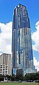
Houston had the fifth-tallest skyline in North America (after New York City, Chicago, Toronto and Miami) and 36th-tallest in the world in 2015.[88] A seven-mile (11 km) system of tunnels and skywalks links Downtown buildings containing shops and restaurants, enabling pedestrians to avoid summer heat and rain while walking between buildings. In the 1960s, Downtown Houston consisted of a collection of mid-rise office structures. Downtown was on the threshold of an energy industry–led boom in 1970. A succession of skyscrapers was built throughout the 1970s—many by real estate developer Gerald D. Hines—culminating with Houston's tallest skyscraper, the 75-floor, 1,002-foot (305 m)-tall JPMorgan Chase Tower (formerly the Texas Commerce Tower), completed in 1982. It is the tallest structure in Texas, 19th tallest building in the United States, and was previously 85th-tallest skyscraper in the world, based on highest architectural feature. In 1983, the 71-floor, 992-foot (302 m)-tall Wells Fargo Plaza (formerly Allied Bank Plaza) was completed, becoming the second-tallest building in Houston and Texas. Based on highest architectural feature, it is the 21st-tallest in the United States. In 2007, Downtown had over 43 million square feet (4,000,000 m2) of office space.[89]
Centered on Post Oak Boulevard and Westheimer Road, the Uptown District boomed during the 1970s and early 1980s when a collection of midrise office buildings, hotels, and retail developments appeared along Interstate 610 West. Uptown became one of the most prominent instances of an edge city. The tallest building in Uptown is the 64-floor, 901-foot (275 m)-tall, Philip Johnson and John Burgee designed landmark Williams Tower (known as the Transco Tower until 1999). At the time of construction, it was believed to be the world's tallest skyscraper outside a central business district. The new 20-story Skanska building[90] and BBVA Compass Plaza[91] are the newest office buildings built in Uptown after 30 years. The Uptown District is also home to buildings designed by noted architects I. M. Pei, César Pelli, and Philip Johnson. In the late 1990s and early 2000s, a mini-boom of midrise and highrise residential tower construction occurred, with several over 30 stories tall.[92][93][94] Since 2000 over 30 skyscrapers have been developed in Houston; all told, 72 high-rises tower over the city, which adds up to about 8,300 units.[95] In 2002, Uptown had more than 23 million square feet (2,100,000 m2) of office space with 16 million square feet (1,500,000 m2) of class A office space.[96]
-
 The Niels Esperson Building stood as the tallest building in Houston from 1927 to 1929.
 -
 The JPMorgan Chase Tower is the tallest building in Texas and the tallest 5-sided building in the world.
 -
 The Williams Tower is the tallest building in the US outside a central business district.
 -


Climate
.jpg)
Houston's climate is classified as humid subtropical (Cfa in the Köppen climate classification system), typical of the Southern United States. While not in Tornado Alley, like much of Northern Texas, spring supercell thunderstorms sometimes bring tornadoes to the area.[97] Prevailing winds are from the south and southeast during most of the year, which bring heat and tropical moisture from the nearby Gulf of Mexico and Galveston Bay.[98]
During the summer, temperatures reach or exceed 90 °F (32 °C) an average of 106.5 days per year, including a majority of days from June to September. Additionally, an average of 4.6 days per year reach or exceed 100 °F (37.8 °C).[99] Houston's characteristic subtropical humidity often results in a higher apparent temperature, and summer mornings average over 90% relative humidity.[100] Air conditioning is ubiquitous in Houston; in 1981, annual spending on electricity for interior cooling exceeded $600 million (equivalent to $2.01 billion in 2023), and by the late 1990s, approximately 90% of Houston homes featured air conditioning systems.[101][102] The record highest temperature recorded in Houston is 109 °F (43 °C) at Bush Intercontinental Airport, during September 4, 2000, and again on August 27, 2011.[99]

Houston has mild winters, with occasional cold spells. In January, the normal mean temperature at George Bush Intercontinental Airport is 53 °F (12 °C), with an average of 13 days per year with a low at or below 32 °F (0 °C), occurring on average between December 3 and February 20, allowing for a growing season of 286 days.[99] Twenty-first century snow events in Houston include a storm on December 24, 2004, which saw 1 inch (3 cm) of snow accumulate in parts of the metro area,[103] and an event on December 7, 2017, which precipitated 0.7 inches (2 cm) of snowfall.[104][105] Snowfalls of at least 1 inch (2.5 cm) on both December 10, 2008, and December 4, 2009, marked the first time measurable snowfall had occurred in two consecutive years in the city's recorded history. Overall, Houston has seen measurable snowfall 38 times between 1895 and 2018. On February 14 and 15, 1895, Houston received 20 inches (51 cm) of snow, its largest snowfall from one storm on record.[106] The coldest temperature officially recorded in Houston was 5 °F (−15 °C) on January 18, 1930.[99] The last time Houston saw single digit temperatures was on December 23, 1989. The temperature dropped to 7 °F (−14 °C) at Bush Airport, marking the coldest temperature ever recorded there. 1.7 inches of snow fell at George Bush Intercontinental Airport the previous day.[107]
Houston generally receives ample rainfall, averaging about 49.8 in (1,260 mm) annually based on records between 1981 and 2010. Many parts of the city have a high risk of localized flooding due to flat topography,[108] ubiquitous low-permeability clay-silt prairie soils,[109] and inadequate infrastructure.[108] During the mid-2010s, Greater Houston experienced consecutive major flood events in 2015 ("Memorial Day"),[110] 2016 ("Tax Day"),[111] and 2017 (Hurricane Harvey).[112] Overall, there have been more casualties and property loss from floods in Houston than in any other locality in the United States.[113] The majority of rainfall occurs between April and October (the wet season of Southeast Texas), when the moisture from the Gulf of Mexico evaporates extensively over the city.[110][113]
Houston has excessive ozone levels and is routinely ranked among the most ozone-polluted cities in the United States.[114] Ground-level ozone, or smog, is Houston's predominant air pollution problem, with the American Lung Association rating the metropolitan area's ozone level twelfth on the "Most Polluted Cities by Ozone" in 2017, after major cities such as Los Angeles, Phoenix, New York City, and Denver.[115] The industries along the ship channel are a major cause of the city's air pollution.[116] The rankings are in terms of peak-based standards, focusing strictly on the worst days of the year; the average ozone levels in Houston are lower than what is seen in most other areas of the country, as dominant winds ensure clean, marine air from the Gulf.[117] Excessive man-made emissions in the Houston area led to a persistent increase of atmospheric carbon dioxide over the city. Such an increase, often regarded as "CO2 urban dome", is driven by a combination of strong emissions and stagnant atmospheric conditions. Moreover, Houston is the only metropolitan area with less than ten million citizens where such a CO2 dome can be detected by satellites.[118]
| Climate data for Houston (Intercontinental Airport), 1991–2020 normals,[a] extremes 1888–present[b] | |||||||||||||
|---|---|---|---|---|---|---|---|---|---|---|---|---|---|
| Month | Jan | Feb | Mar | Apr | May | Jun | Jul | Aug | Sep | Oct | Nov | Dec | Year |
| Record high °F (°C) | 85 (29) |
91 (33) |
96 (36) |
95 (35) |
99 (37) |
107 (42) |
105 (41) |
109 (43) |
109 (43) |
99 (37) |
89 (32) |
85 (29) |
109 (43) |
| Mean maximum °F (°C) | 78.9 (26.1) |
81.2 (27.3) |
85.4 (29.7) |
88.6 (31.4) |
93.8 (34.3) |
97.8 (36.6) |
99.1 (37.3) |
101.2 (38.4) |
97.3 (36.3) |
92.2 (33.4) |
84.9 (29.4) |
80.7 (27.1) |
102.1 (38.9) |
| Mean daily maximum °F (°C) | 63.8 (17.7) |
67.8 (19.9) |
74.0 (23.3) |
80.1 (26.7) |
86.9 (30.5) |
92.3 (33.5) |
94.5 (34.7) |
94.9 (34.9) |
90.4 (32.4) |
82.8 (28.2) |
72.6 (22.6) |
65.3 (18.5) |
80.5 (26.9) |
| Daily mean °F (°C) | 53.8 (12.1) |
57.7 (14.3) |
63.8 (17.7) |
70.0 (21.1) |
77.4 (25.2) |
83.0 (28.3) |
85.1 (29.5) |
85.2 (29.6) |
80.5 (26.9) |
71.8 (22.1) |
62.0 (16.7) |
55.4 (13.0) |
70.5 (21.4) |
| Mean daily minimum °F (°C) | 43.7 (6.5) |
47.6 (8.7) |
53.6 (12.0) |
59.8 (15.4) |
67.8 (19.9) |
73.7 (23.2) |
75.7 (24.3) |
75.4 (24.1) |
70.6 (21.4) |
60.9 (16.1) |
51.5 (10.8) |
45.6 (7.6) |
60.5 (15.8) |
| Mean minimum °F (°C) | 27.5 (−2.5) |
31.6 (−0.2) |
35.0 (1.7) |
43.4 (6.3) |
53.8 (12.1) |
66.5 (19.2) |
70.5 (21.4) |
70.0 (21.1) |
58.3 (14.6) |
44.1 (6.7) |
34.2 (1.2) |
30.0 (−1.1) |
26.0 (−3.3) |
| Record low °F (°C) | 5 (−15) |
6 (−14) |
21 (−6) |
31 (−1) |
42 (6) |
52 (11) |
62 (17) |
54 (12) |
45 (7) |
29 (−2) |
19 (−7) |
7 (−14) |
5 (−15) |
| Average precipitation inches (mm) | 3.76 (96) |
2.97 (75) |
3.47 (88) |
3.95 (100) |
5.01 (127) |
6.00 (152) |
3.77 (96) |
4.84 (123) |
4.71 (120) |
5.46 (139) |
3.87 (98) |
4.03 (102) |
51.84 (1,317) |
| Average snowfall inches (cm) | 0.0 (0.0) |
0.0 (0.0) |
0.0 (0.0) |
0.0 (0.0) |
0.0 (0.0) |
0.0 (0.0) |
0.0 (0.0) |
0.0 (0.0) |
0.0 (0.0) |
0.0 (0.0) |
0.0 (0.0) |
0.1 (0.25) |
0.1 (0.25) |
| Average precipitation days (≥ 0.01 in) | 10.0 | 8.8 | 8.8 | 7.3 | 8.6 | 10.0 | 9.1 | 8.5 | 8.4 | 7.7 | 7.6 | 9.6 | 104.4 |
| Average snowy days (≥ 0.1 in) | 0.0 | 0.0 | 0.0 | 0.0 | 0.0 | 0.0 | 0.0 | 0.0 | 0.0 | 0.0 | 0.0 | 0.1 | 0.1 |
| Average relative humidity (%) | 74.7 | 73.4 | Zdroj:https://en.wikipedia.org?pojem=Houston,_Texas|||||||||||