

A | B | C | D | E | F | G | H | CH | I | J | K | L | M | N | O | P | Q | R | S | T | U | V | W | X | Y | Z | 0 | 1 | 2 | 3 | 4 | 5 | 6 | 7 | 8 | 9

Pôvodný súbor (3 053 × 2 246 pixelov, veľkosť súboru: 91,58 MB, MIME typ: image/tiff)
Zhrnutie
| Popis |
English: The lush landscape of the island of Ireland and the coasts of Scotland, Wales and England, are pictured in this view from the Copernicus Sentinel-3 mission.
Zoom in to explore this image at its full resolution or click on the circles to learn more. The island of Ireland consists of Northern Ireland, in the top eastern corner, and the Republic of Ireland to the south. The island of Ireland lies west of Great Britain, separated by the North Channel, the Irish Sea and St. George’s Channel. The image is from January 2024 and was captured on a relatively clear winter day. Ireland enjoys a mild climate, owing to the influence of the Atlantic Ocean (to the left) and the presence of the Gulf Stream. South-westerly winds from the Atlantic tend to bring a lot of rain in the northwest, west and southwest of the country. The extensive grasslands that cover most of the country, washed by abundant rainfall all year, create the typical emerald-green landscape, hence it being known as the Emerald Isle. Brown rugged cliffs along the west coast frame the island’s green interior, speckled by hundreds of lakes, visible as dark spots in the image. Clear to see are the mountains of Donegal (north), Mayo and Galway (west) and the Macgillycuddy’s Reeks in the southwest. Carrantuohill in the Macgillycuddy’s Reeks is the highest point on the island. Owing to high concentrations of algae in the water, green and brownish swirls can be seen off the coastlines. |
| Dátum | |
| Zdroj | https://www.esa.int/ESA_Multimedia/Images/2024/03/Earth_from_Space_Ireland |
| Autor | modified Copernicus Sentinel data (2024), processed by ESA |
Licencovanie

|
This image contains data from a satellite in the Copernicus Programme, such as Sentinel-1, Sentinel-2 or Sentinel-3. Attribution is required when using this image.
Uvedenie autora: Contains modified Copernicus Sentinel data 2024
The use of Copernicus Sentinel Data is regulated under EU law (Commission Delegated Regulation (EU) No 1159/2013 and Regulation (EU) No 377/2014). Relevant excerpts:
Free access shall be given to GMES dedicated data made available through GMES dissemination platforms .
Access to GMES dedicated data shall be given for the purpose of the following use in so far as it is lawful:
GMES dedicated data may be used worldwide without limitations in time.
GMES dedicated data and GMES service information are provided to users without any express or implied warranty, including as regards quality and suitability for any purpose. |
This media was created by the European Space Agency (ESA).
Where expressly so stated, images or videos are covered by the Creative Commons Attribution-ShareAlike 3.0 IGO (CC BY-SA 3.0 IGO) licence, ESA being an Intergovernmental Organisation (IGO), as defined by the CC BY-SA 3.0 IGO licence. The user is allowed under the terms and conditions of the CC BY-SA 3.0 IGO license to Reproduce, Distribute and Publicly Perform the ESA images and videos released under CC BY-SA 3.0 IGO licence and the Adaptations thereof, without further explicit permission being necessary, for as long as the user complies with the conditions and restrictions set forth in the CC BY-SA 3.0 IGO licence, these including that:
See the ESA Creative Commons copyright notice for complete information, and this article for additional details.
|
 | |
Tento soubor podléhá licenci Creative Commons Uveďte autora-Zachovejte licenci 3.0 IGO. Uvedenie autora: ESA, CC BY-SA IGO 3.0
| ||
História súboru
Po kliknutí na dátum/čas uvidíte ako súbor vyzeral vtedy.
| Dátum/Čas | Náhľad | Rozmery | Používateľ | Komentár | |
|---|---|---|---|---|---|
| aktuálna | 16:28, 8. marec 2024 | 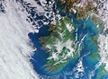 | 3 053 × 2 246 (91,58 MB) | Artem.G | Uploaded a work by modified Copernicus Sentinel data (2024), processed by ESA from https://www.esa.int/ESA_Multimedia/Images/2024/03/Earth_from_Space_Ireland with UploadWizard |
Použitie súboru
Žiadne stránky neobsahujú odkazy na tento súbor.
Globálne využitie súborov
Nasledovné ďalšie wiki používajú tento súbor:
- Použitie na en.wikipedia.org
Metadáta
Text je dostupný za podmienok Creative Commons Attribution/Share-Alike License 3.0 Unported; prípadne za ďalších podmienok. Podrobnejšie informácie nájdete na stránke Podmienky použitia.
Antropológia
Aplikované vedy
Bibliometria
Dejiny vedy
Encyklopédie
Filozofia vedy
Forenzné vedy
Humanitné vedy
Knižničná veda
Kryogenika
Kryptológia
Kulturológia
Literárna veda
Medzidisciplinárne oblasti
Metódy kvantitatívnej analýzy
Metavedy
Metodika
Text je dostupný za podmienok Creative
Commons Attribution/Share-Alike License 3.0 Unported; prípadne za ďalších
podmienok.
Podrobnejšie informácie nájdete na stránke Podmienky
použitia.
www.astronomia.sk | www.biologia.sk | www.botanika.sk | www.dejiny.sk | www.economy.sk | www.elektrotechnika.sk | www.estetika.sk | www.farmakologia.sk | www.filozofia.sk | Fyzika | www.futurologia.sk | www.genetika.sk | www.chemia.sk | www.lingvistika.sk | www.politologia.sk | www.psychologia.sk | www.sexuologia.sk | www.sociologia.sk | www.veda.sk I www.zoologia.sk