A | B | C | D | E | F | G | H | CH | I | J | K | L | M | N | O | P | Q | R | S | T | U | V | W | X | Y | Z | 0 | 1 | 2 | 3 | 4 | 5 | 6 | 7 | 8 | 9
Northamptonshire
Northants | |
|---|---|
 | |
| Coordinates: 52°17′N 0°50′W / 52.283°N 0.833°W | |
| Sovereign state | United Kingdom |
| Constituent country | England |
| Region | East Midlands |
| Time zone | UTC+0 (GMT) |
| • Summer (DST) | UTC+1 (BST) |
| UK Parliament | 7 MPs |
| Police | Northamptonshire Police |
| Ceremonial county | |
| Lord Lieutenant | David Laing[1] |
| High Sheriff | Paul Parsons[2] (2020/21) |
| Area | 2,364 km2 (913 sq mi) |
| • Rank | 24th of 48 |
| Population (2022)[3] | 792,421 |
| • Rank | 31st of 48 |
| Density | 335/km2 (870/sq mi) |
| Ethnicity |
|
| Unitary authorities | |
| Councils | West Northamptonshire Council North Northamptonshire Council |
| Districts | |
 Districts of Northamptonshire Unitary: | |
Northamptonshire (/nɔːrˈθæmptənʃɪər, -ʃər/;[4][5] abbreviated Northants.) is a ceremonial county in the East Midlands of England. It is bordered by Leicestershire, Rutland and Lincolnshire to the north, Cambridgeshire to the east, Bedfordshire, Buckinghamshire, Oxfordshire to the south and Warwickshire to the west. Northampton is the largest settlement and the county town.
The county has an area of 2,364 km2 (913 sq mi) and a population of 747,622. The latter is concentrated in the centre of the county, which contains the county's largest towns: Northampton (249,093), Corby (75,571), Kettering (63,150), and Wellingborough (56,564).[citation needed] The northeast and southwest are rural. The county contains two local government districts, North Northamptonshire and West Northamptonshire, which are both unitary authority areas. The historic county included the Soke of Peterborough.
The county is characterised by low, undulating hills, particularly to the west. They are the source of several rivers, including the Avon and Welland, which form much of the northern border; the Cherwell; and the Great Ouse. The River Nene is the principal river within the county, having its source in the southwest and flowing northeast past Northampton and Wellingborough. The highest point is Arbury Hill southwest of Daventry, at 225 m (738 ft).
There are Iron Age and Roman remains in the county, and in the seventh century it was settled by the Angles and Saxons, becoming part of Mercia. The county likely has its origin in the Danelaw as the area controlled from Northampton, which was one of the Five Boroughs. In the later Middle Ages and Early Modern Period the county was relatively settled, although Northampton was the location of engagements during the First and Second Barons' Wars and the Wars of the Roses, and during the First English Civil War Naseby was the site of a decisive battle which destroyed the main Royalist army. During the Industrial Revolution Northamptonshire became known for its footwear, and the contemporary county has a number of small industrial centres which specialise in engineering and food processing.[6][7]
History
Much of Northamptonshire's countryside appears to have remained somewhat intractable as regards early human occupation, resulting in an apparently sparse population and relatively few finds from the Palaeolithic, Mesolithic and Neolithic periods.[8] In about 500 BC the Iron Age was introduced into the area by a continental people in the form of the Hallstatt culture,[9] and over the next century a series of hill-forts were constructed at Arbury Camp, Rainsborough camp, Borough Hill, Castle Dykes, Guilsborough, Irthlingborough, and most notably of all, Hunsbury Hill. There are two more possible hill-forts at Arbury Hill (Badby) and Thenford.[9]

In the 1st century BC, most of what later became Northamptonshire became part of the territory of the Catuvellauni, a Belgic tribe, the Northamptonshire area forming their most northerly possession.[9] The Catuvellauni were in turn conquered by the Romans in 43 AD.[10]
The Roman road of Watling Street passed through the county, and an important Roman settlement, Lactodurum, stood on the site of modern-day Towcester. There were other Roman settlements at Northampton, Kettering and along the Nene Valley near Raunds. A large fort was built at Longthorpe.[9]
After the Romans left, the area eventually became part of the Anglo-Saxon kingdom of Mercia, and Northampton functioned as an administrative centre. The Mercians converted to Christianity in 654 AD with the death of the pagan king Penda.[11] From about 889 the area was conquered by the Danes (as at one point almost all of England was, except for Athelney marsh in Somerset) and became part of the Danelaw – with Watling Street serving as the boundary – until being recaptured by the English under the Wessex king Edward the Elder, son of Alfred the Great, in 917. Northamptonshire was conquered again in 940, this time by the Vikings of York, who devastated the area, only for the county to be retaken by the English in 942.[12] Consequently, it is one of the few counties in England to have both Saxon and Danish town-names and settlements.[citation needed]
The county was first recorded in the Anglo-Saxon Chronicle (1011), as Hamtunscire: the scire (shire) of Hamtun (the homestead). The "North" was added to distinguish Northampton from the other important Hamtun further south: Southampton – though the origins of the two names are in fact different.[13]
Rockingham Castle was built for William the Conqueror[14] and was used as a Royal fortress until Elizabethan times. In 1460, during the Wars of the Roses, the Battle of Northampton took place and King Henry VI was captured.[15] The now-ruined Fotheringhay Castle was used to imprison Mary, Queen of Scots, before her execution.[16]

During the English Civil War, Northamptonshire strongly supported the Parliamentarian cause, and the Royalist forces suffered a crushing defeat at the Battle of Naseby in 1645 in the north of the county. King Charles I was imprisoned at Holdenby House in 1647.[17]
George Washington, the first President of the United States of America, was born into the Washington family who had migrated to America from Northamptonshire in 1656. George Washington's ancestor, Lawrence Washington, was Mayor of Northampton on several occasions and it was he who bought Sulgrave Manor from Henry VIII in 1539. It was George Washington's great-grandfather, John Washington, who emigrated in 1656 from Northamptonshire to Virginia. Before Washington's ancestors moved to Sulgrave, they lived in Warton, Lancashire.[18]
In the 18th and 19th centuries, parts of Northamptonshire and the surrounding area became industrialised. The local specialisation was shoemaking and the leather industry and became one of Britain's major centres for these crafts by the 19th century. In the north of the county a large ironstone quarrying industry developed from 1850.[19]
In 1823 Northamptonshire was said to " a very pure and wholesome air" because of its dryness and distance from the sea. Its livestock were celebrated: "Horned cattle, and other animals, are fed to extraordinary sizes: and many horses of the large black breed are reared."[20]
Nine years later, the county was described as "a county enjoying the reputation of being one of the healthiest and pleasantest parts of England" although the towns were "of small importance" with the exceptions of Peterborough and Northampton. In summer, the county hosted "a great number of wealthy families... country seats and villas are to be seen at every step."[21] Northamptonshire is still referred to as the county of "spires and squires" because of the numbers of stately homes and ancient churches.[22]
Prior to 1901 the ancient hundreds were disused. Northamptonshire was administered as four major divisions: Northern, Eastern, Mid, and Southern.[23] During the 1930s, the town of Corby was established as a major centre of the steel industry. Much of Northamptonshire nevertheless remains rural.[citation needed]
Corby was designated a new town in 1950[24] and Northampton followed in 1968.[25] As of 2005[update] the government is encouraging development in the South Midlands area, including Northamptonshire.[26]
Peterborough
The Soke of Peterborough was historically associated with and considered part of Northamptonshire and the Church of England Diocese of Peterborough that covers Northamptonshire is centred in Peterborough Cathedral.[27] However, Peterborough had its own courts of quarter sessions and, later, county council. In 1965 the administration was merged with that of neighbouring Huntingdonshire.[28] Under the Local Government Act 1972 the city of Peterborough became a district of Cambridgeshire.[29]
Little Bowden
In 1879, a local government district was created covering the three parishes of Market Harborough and Great Bowden and Little Bowden.[30] When elected county councils were established in 1889, local government districts were placed entirely in one county, and thus the parish of Little Bowden, a neighbourhood of Market Harborough, was transferred from Northamptonshire to Leicestershire.[31]
Geography

Northamptonshire is a landlocked county located in the southern part of the East Midlands region,[32] which is sometimes known as the South Midlands. The county contains the watershed between the River Severn and The Wash, and several important rivers have their sources in the north-west of the county, including the River Nene, which flows north-eastwards to The Wash, and the "Warwickshire Avon", which flows south-west to the Severn. In 1830, it was boasted that "not a single brook, however insignificant, flows into it from any other district".[33] The highest point in the county is Arbury Hill, at 225 metres (738 ft).[34][35] The boundary with Lincolnshire is England's shortest ceremonial county boundary, at 20 yards (18 metres).[36]
There are several towns in the county, Northampton being the largest and most populous. At the time of the 2011 census a population of 691,952 lived in the county, with 212,069 living in Northampton. The table below shows all towns with over 10,000 inhabitants.
| Rank | Town | Population | Former Borough/District council |
|---|---|---|---|
| 1 | Northampton | 249,093 (2021) | Northampton Borough Council |
| 2 | Corby | 75,571 (2021) | Corby Borough Council |
| 3 | Kettering | 63,150 (2021) | Kettering Borough Council |
| 4 | Wellingborough | 56,564 (2021) | Borough Council of Wellingborough |
| 5 | Rushden | 31,690 (2021) | East Northamptonshire District Council |
| 6 | Daventry | 28,123 (2021) | Daventry District Council |
| 7 | Brackley | 16,159 (2021) | South Northamptonshire District Council |
| 8 | Towcester | 11,524 (2021) | South Northamptonshire District Council |
As of 2010 there were 16 settlements in Northamptonshire with a town charter:
- Brackley, Burton Latimer, Corby, Daventry, Desborough, Higham Ferrers, Irthlingborough, Kettering, Northampton, Oundle, Raunds, Rothwell, Rushden, Towcester, Thrapston and Wellingborough.
Climate
Like the rest of the British Isles, Northamptonshire has an oceanic climate (Köppen climate classification). The table below shows the average weather for Northamptonshire from the Moulton weather station.
| Climate data for Moulton, Northants | |||||||||||||
|---|---|---|---|---|---|---|---|---|---|---|---|---|---|
| Month | Jan | Feb | Mar | Apr | May | Jun | Jul | Aug | Sep | Oct | Nov | Dec | Year |
| Mean daily maximum °C (°F) | 7 (45) |
8 (46) |
11 (52) |
13 (55) |
17 (63) |
19 (66) |
22 (72) |
23 (73) |
19 (66) |
14 (57) |
10 (50) |
7 (45) |
14 (58) |
| Mean daily minimum °C (°F) | 2 (36) |
2 (36) |
4 (39) |
4 (39) |
7 (45) |
10 (50) |
12 (54) |
12 (54) |
10 (50) |
8 (46) |
5 (41) |
3 (37) |
7 (44) |
| Average precipitation cm (inches) | 4.51 (1.78) |
3.39 (1.33) |
2.87 (1.13) |
4.39 (1.73) |
3.49 (1.37) |
4.66 (1.83) |
4.21 (1.66) |
4.69 (1.85) |
5.49 (2.16) |
5.68 (2.24) |
4.8 (1.9) |
4.98 (1.96) |
53.16 (20.94) |
| Source: [37] | |||||||||||||
Governance
Local government
Between 1974 and 2021, Northamptonshire, like most English counties, was divided into a number of local authorities. The seven borough/district councils covered 15 towns and hundreds of villages. The county had a two-tier structure of local government and an elected county council based in Northampton, and was also divided into seven districts each with their own district or borough councils:[38]
Northampton itself is the most populous civil parish in England, and (prior to 2021) was the most populous urban district in England not to be administered as a unitary authority (even though several smaller districts are unitary). During the 1990s local government reform, Northampton Borough Council petitioned strongly for unitary status, which led to fractured relations with the County Council.[citation needed]
The Soke of Peterborough is within the historic county of Northamptonshire, although it had had a separate county council since 1889 and separate courts of quarter sessions before then. The city of Peterborough has been a unitary authority since 1998, but it forms part of Cambridgeshire for ceremonial purposes.[39]
De facto bankruptcy of the county council
In early 2018, Northamptonshire County Council was declared technically insolvent and would be able to provide only the bare essential services.[40] According to The Guardian the problems were caused by "a reckless half-decade in which it refused to raise council tax to pay for the soaring costs of social care" and "partly due to past failings, the council is now having to make some drastic decisions to reduce services to a core offer." Some observers, such as Simon Edwards of the County Councils Network, added another perspective on the cause of the financial crisis, the United Kingdom government austerity programme: "It is clear that, partly due to past failings, the council is now having to make some drastic decisions to reduce services to a core offer. However, we can't ignore that some of the underlying causes of the challenges facing Northamptonshire, such as dramatic reductions to council budgets and severe demand for services, mean county authorities across the country face funding pressures of £3.2bn over the next two years."[41]
Structural changes
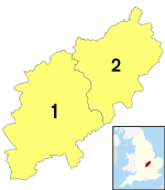
In early 2018, following the events above, Government-appointed commissioners took over control of the council's affairs. Consequently, the Secretary of State for Housing, Communities and Local Government commissioned an independent report which, in March 2018, proposed structural changes to local government in Northamptonshire. These changes, implemented on 1 April 2021, saw the existing county council and district councils abolished and two new unitary authorities created in their place.[42] One unitary authority, West Northamptonshire, consists of the former districts of Daventry, Northampton and South Northamptonshire; the other, North Northamptonshire, consists of the former East Northamptonshire district and the former boroughs of Corby, Kettering and Wellingborough.[43]
National representation
Northamptonshire returns seven Members of Parliament (MPs). As of 2024[update], six are currently from the Conservative Party and one from the Labour Party.[44] Several of the constituencies have been marginal in the past, including the Northampton seats, Wellingborough, Kettering, and Corby, which were all Labour seats before 2005. In the 2016 EU referendum, all of the Northamptonshire districts voted to Leave, most by a significant margin.


