

A | B | C | D | E | F | G | H | CH | I | J | K | L | M | N | O | P | Q | R | S | T | U | V | W | X | Y | Z | 0 | 1 | 2 | 3 | 4 | 5 | 6 | 7 | 8 | 9
Rhodes
Ρόδος | |
|---|---|
From top, left to right: View to Rhodes and the palace, statue of Diagoras of Rhodes carried by his sons, St. Catherine gate, Eleftherios Venizelos Street with the Konstantinos Karamanlis statue, view to the mosque of Suleiman, Rhodian Deer statues in the city's port, aerial view of the Palace of the Grand Master. | |
 Flag | |
 Rhodes Location within Rhodes  | |
| Coordinates: 36°26′N 28°13′E / 36.433°N 28.217°E | |
| Country | Greece |
| Administrative region | South Aegean |
| Regional unit | Rhodes |
| Municipality | Rhodes |
| Area | |
| • Municipal unit | 19.481 km2 (7.522 sq mi) |
| Elevation | 26 m (85 ft) |
| Population (2021)[1] | |
| • Metro | 86,199 |
| • Municipal unit | 56,440 |
| • Municipal unit density | 2,900/km2 (7,500/sq mi) |
| Demonym(s) | Rhodian, Rhodiot or Rhodiote (rare) Rhoditis (Greek) |
| Time zone | UTC+2 (EET) |
| • Summer (DST) | UTC+3 (EEST) |
| Postal code | 851 00, 31, 32, 33 |
| Area code(s) | 2241 |
| Vehicle registration | PO, PK, PY |
| Website | www.rhodes.gr |


_1.jpg)


.jpg)
Rhodes (Greek: Ρόδος, Ródos [ˈroðos]) is the principal city and a former municipality on the island of Rhodes in the Dodecanese, Greece. Since the 2011 local government reform, it is part of the municipality Rhodes, of which it is the seat and a municipal unit.[2] It has a population of approximately 56,000 inhabitants (near 90,000 in its metropolitan area). Rhodes has been famous since antiquity as the site of Colossus of Rhodes, one of the Seven Wonders of the Ancient World. The citadel of Rhodes, built by the Hospitalliers, is one of the best-preserved medieval towns in Europe. The Medieval city is designated as a UNESCO World Heritage Site.[3]
Today, the city of Rhodes is an important Greek urban center and popular international tourist destination.
History
The island of Rhodes is at a crossroads between Europe, the Middle East, and Africa. This has given the city and the island many different identities, cultures, architectures, and languages over its long history. Its position in major sea routes has given Rhodes a very rich history. The island has been inhabited since about 4000 BC (Neolithic Period).[4]
Classical period


The city of Rhodes was formed by the cities of Ialyssos, Kamiros and Lindos in 408 BC,[4] and prospered for three centuries during its Golden Age, when sea trade, skilled shipbuilders, and open-minded politicians of the city kept it prosperous until Roman times. The Colossus of Rhodes, one of the original Seven Wonders of the Ancient World was built by Chares of Lindos between 304 and 293 BC,[4] which took 12 years and was completed in 282 BC. The statue represented their sun god Helios, and is believed to have stood near the harbour entrance. The ancient city had a well-constructed sewage system as well as a water supply network as designed by Hippodamus. A strong earthquake hit Rhodes about 226 BC, badly damaging the city and toppling the Colossus.[4]
Roman period
In 164 BC, Rhodes came under Roman control.[5] It was able to keep its beauty and develop into a leading center of learning for arts and science. The Romans took from the Rhodians their maritime law and applied it to their shipping. Many traces of the Roman period still exist throughout the city and give an insight into the level of civilization at the time.[5] According to Acts 21:1, the Apostle Paul stopped at Rhodes near the end of his third missionary journey.
Byzantine period
In medieval times, Rhodes was an important Byzantine trading post, as also a crossroads for ships sailing between Constantinople and Alexandria. In the early years of the divided Roman Empire, the Isaurians, a mountain tribe from Cilicia, invaded the island and burned the city. In the 7th century AD it was captured by the Arabs. The latter were the ones who removed the scattered pieces of the Colossus from the port and moved them to Syria where they destroyed them to make coins. After the fall of the Byzantine Empire to the Fourth Crusade in 1204, the native noble Leo Gabalas took control of the island, but after his death and succession by his brother John, the island was briefly occupied by the Genoese before being returned to the Emperor of Nicaea, though ushering in a new, but short-lived, Byzantine period.
Knights' period


The Knights Hospitallers captured and established their headquarters on Rhodes when they left Cyprus[6][7] after the persecution of the Knights Templar in 1307. Pope Clement V confirmed the Hospitallers possession of the island in 1309. The Knights remained on the island for the next two centuries.
In 1444, the Mamluk fleet led by Aynal Gecut laid siege to Rhodes, but the Knights, aided by the Burgundian naval commander Geoffroy de Thoisy, beat off the Muslim attack.
After the Fall of Constantinople in 1453, the Ottoman Empire began a rapid expansion, and in 1480 Sultan Mehmed the Conqueror sent an invasion force to Rhodes commanded by Mesih Pasha. In this first Ottoman Siege of Rhodes, the defenders repelled Turkish attacks from both landward and seaward sides and the invaders left the island in defeat. The defeat halted a concurrent invasion of the Italian peninsula by Ottoman forces and prevented possible Muslim incursion and control of Western Europe.

After the Ottoman defeat in 1480, the Knights Grand Master, Pierre d'Aubusson, oversaw the strengthening of the cities over the next few decades. By the time of his death in 1521, Rhodes possessed among the strongest fortifications of any Christian bastion in the world, including underground passages to the moat that could have quickly been blown up in case of withdrawal.[8] The Knights continued naval attacks launched from Rhodes on Muslim merchants until 1522, when the newly enthroned Sultan Suleiman the Magnificent led a second Ottoman Siege of Rhodes in 1522.
The vastly outnumbered Knights made a spirited defense of the city and inflicted heavy casualties upon the Ottoman besiegers. In December 1522, the Knights and Suleiman came to terms and the Knights were allowed to leave the city with all the wealth they could carry, and in return there would be no retribution upon the inhabitants of the city and they would be allowed to continue to freely practice Christianity. On January 1, 1523 the Knights departed from the island, leaving it to Ottoman control.
Ottoman period

In the Ottoman era, new buildings were constructed: mosques, public baths and mansions for the new patrons. The Greeks were forced to abandon the fortified city and move to new suburbs outside its walls. The city maintained its main economic function as a market for the agricultural products of the interior of the island and the surrounding small islands.
After the establishment of their sovereignty on the island, the Ottoman Turks converted most of the churches into mosques and transformed the major houses into private mansions or public buildings. This transformation was a long-term process that aimed to adapt the buildings to the Ottoman way of living. The Knights period façades with their sculptured decorations, the arched gates and hewn stone walls were enriched with the random character of the Ottoman architecture adapted to the local climate and culture. Ιn this process most of the architectural features of the existing buildings were preserved. The most characteristic additions were the baths (usually in the back of the buildings) and the enclosed wooden balconies on the façades over the narrow streets. In this way most of the buildings of the Hospitaliers' period in the Medieval Town were well preserved. The result was a mixture of oriental architecture with imposing western architectural remains and more recent buildings, which were characteristic of the local architecture of the time.
An interesting example of Ottoman architecture is the building of the Hafiz Ahmed Agha Library.
Ιn the 19th century, the city was the capital of the Eyalet of the Archipelago, but the decline of the Ottoman Empire resulted in the general neglect of the town and its buildings, which further deteriorated due to the strong earthquakes that often plague the area.
In 1856, a gunpowder magazine under the old Church of Saint John – possibly stored there since the siege of 1522[9][10] – was struck by lightning, causing a massive explosion that killed many people, destroyed the church, and destroyed much of the Grand Master's Palace.[9][11][12][10]
Italian period
_03.jpg)


In 1912 Italian troops took the island over with the rest of the Dodecanese Islands, and established an Italian possession known as Italian Islands of the Aegean in 1923.[13] The architect Florestano Di Fausto can be considered the father of Italian Rhodes. He, in agreement with governor Mario Lago, was author of the city plan of 1923, choosing to respect almost totally the walled town, only demolishing the houses that were built on and around the city walls during the Ottoman era. He also turned the Jewish and Ottoman cemeteries into a green zone surrounding the Medieval Town.[13] At the same time, he designed the new Italian Rhodes in the zone of the Mandraki, planning a Garden City, and building along the main sea promenade the main edifices, as the Market, the Cathedral of Saint John of the Knights, the Palace of the governor. All these building were designed in an eclectic style, mixing Ottoman, Venetian, Renaissance and local elements. The Italians preserved what was left from the Knights' period, and destroyed all Ottoman buildings. They also reconstructed the Grand Master's Palace.[13] Furthermore, an Institute for the study of the History and Culture of the region was established, and major infrastructure work was done to modernize Rhodes.[13]
World War II and postwar period
During World War II, Allied bombing raids which targeted the old city of Rhodes in 1944 destroyed a significant portion of the city.[citation needed] One of the first decrees of the Greek government designated those areas as reserved for future excavations and a number of edifices as safeguarded buildings. In July 1944, the Nazi authorities ordered the deportation of over 1,700 Jews of Rhodes including men, women, and children, of whom 1,200 were murdered at Auschwitz.[14]
In 1957, a new city plan was approved by a decree and in 1960 the entire medieval town was designated as a protected monument by the Ministry of Culture. In 1961 and 1963 new decrees were issued concerning the new city plan. They provided for the widening of existing streets and the opening of new ones. However, these were not implemented in the old city due to the resistance of the Archaeological Service. In 1988, the old town of Rhodes was designated as a World Heritage City by UNESCO.
Government
Rhodes City is the capital of the island of Rhodes which since 2011 became a single municipality and of the Rhodes regional unit. It was the capital of the former Dodecanese Prefecture and currently hosts many offices and services of the South Aegean region.
As an administration centre, the city also hosts numerous offices and services such as:
- Dodecanese Police Headquarters
- Rhodes Fire Department
- Dodecanese Courthouse
- Dodecanese Port Police/Coastguard
- 95 ADTE (Hellenic Army Division Headquarters)
- Rhodes Public Tax Office
- Rhodes Urban Planning Office
- Rhodes Land Registry Office
- Rhodes Hellenic Post Office headquarters
- Rhodes Municipal Water & Sewage Company
- Dodecanese Chamber of Commerce
- Rhodes Manpower Office (OAED)
- Rhodes Social Security Institute (IKA)
- Public Power Corporation (DEI)
Main sights
The city is home to numerous landmarks. Some of them date back to antiquity and most of the others remain from the Hospitaller period.
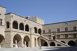
- Grand Master's Palace (15th century)
- Street of the Knights of Rhodes
- La Juderia, including the Kahal Shalom Synagogue
- Acropolis of Rhodes
- Mehmet Aga Mosque
- Mosque of Suleiman the Magnificent
- Medieval walls, created in the mid-14th century on a previous line and remade after the Ottoman siege of 1480 and the earthquake of the following year. In 1522 Suleiman entered the city from the gate of St. Anastasius
- Gothic buildings in the historical upper town.
- Recently, the Byzantine harbor was excavated, discovering unique medieval shipwrecks.
- St. Francis of Assisi Cathedral, Rhodes
- Panagia tou Kastrou
- Palace of the Grand Master of the Knights of Rhodes
-

-
 Close-up view of the Palace
 -
 Interior of the palace
 -
 View of the moat


Geography
The city of Rhodes is situated in the north-east tip of the island and forms a triangle from north to south. The municipal unit has an area of 19.481 km2.[15] It is the smallest municipal unit of the island in terms of land area and the largest in population. It borders the Aegean Sea to the north, the east and the west and with the municipalities of Ialysos and Kallithea in the south.
Climate
In Köppen climate classification, it is classified as hot-summer Mediterranean climate (Csa). According to the data of the meteorological station of the Municipal Port Fund of South Dodecanese, which is located in the Port of Rhodes, the city registers an average annual temperature of 20.8°C.
| Climate data for Rhodes Port 4 m a.s.l. | |||||||||||||
|---|---|---|---|---|---|---|---|---|---|---|---|---|---|
| Month | Jan | Feb | Mar | Apr | May | Jun | Jul | Aug | Sep | Oct | Nov | Dec | Year |
| Record high °C (°F) | 20.8 (69.4) |
20.9 (69.6) |
24.6 (76.3) |
27.6 (81.7) |
36.4 (97.5) |
33.8 (92.8) |
37.4 (99.3) |
37.6 (99.7) |
34.4 (93.9) |
32.6 (90.7) |
26.8 (80.2) |
22.2 (72.0) |
37.6 (99.7) |
| Mean daily maximum °C (°F) | 16.1 (61.0) |
16.4 (61.5) |
17.3 (63.1) |
20.2 (68.4) |
23.9 (75.0) |
27.2 (81.0) |
30.7 (87.3) |
30.5 (86.9) |
28.6 (83.5) |
25.5 (77.9) |
22.0 (71.6) |
18.4 (65.1) |
23.1 (73.5) |
| Daily mean °C (°F) | 14.0 (57.2) |
14.3 (57.7) |
15.1 (59.2) |
18.0 (64.4) |
21.4 (70.5) |
24.8 (76.6) |
28.0 (82.4) |
28.3 (82.9) |
26.5 (79.7) |
23.4 (74.1) |
19.9 (67.8) |
16.3 (61.3) |
20.8 (69.5) |
| Mean daily minimum °C (°F) | 11.9 (53.4) |
12.2 (54.0) |
12.9 (55.2) |
15.7 (60.3) |
18.9 (66.0) |
22.4 (72.3) |
25.3 (77.5) |
26.0 (78.8) |
24.4 (75.9) |
21.2 (70.2) |
17.7 (63.9) |
14.2 (57.6) |
18.6 (65.4) |
| Record low °C (°F) | 2.9 (37.2) |
4.7 (40.5) |
3.8 (38.8) |
9.4 (48.9) |
14.2 (57.6) |
16.2 (61.2) |
22.4 (72.3) |
23.1 (73.6) |
18.7 (65.7) |
17.1 (62.8) |
13.3 (55.9) |
9.0 (48.2) |
2.9 (37.2) |
| Average rainfall mm (inches) | 113.6 (4.47) |
58.5 (2.30) |
44.5 (1.75) |
19.2 (0.76) |
7.3 (0.29) |
7.5 (0.30) |
0.1 (0.00) |
0.3 (0.01) |
3.0 (0.12) |
26.7 (1.05) |
87.2 (3.43) |
144.1 (5.67) |
512 (20.15) |
| Mean monthly sunshine hours | 151.8 | 184.8 | 238.8 | 266 | 326.8 | 375.2 | 394.4 | 363.8 | 311.8 | 260.2 | 190.8 | 157.8 | 3,222.2 |
| Source 1: Municipal Port Fund of South Dodecanese (Jan 2019-Apr 2024) [16] [17] | |||||||||||||
| Source 2: Sunshine Rhodes AP [18] | |||||||||||||