A | B | C | D | E | F | G | H | CH | I | J | K | L | M | N | O | P | Q | R | S | T | U | V | W | X | Y | Z | 0 | 1 | 2 | 3 | 4 | 5 | 6 | 7 | 8 | 9
Caraga
Region XIII | |
|---|---|
| Caraga Administrative Region | |
|
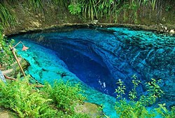
From top, left to right: A naked beach in Siargao Island; Tinuy-an Falls; Rice Corn and Flower Festival in Bayugan; Macapagal Bridge in Butuan; A lagoon in Libjo; Hinatuan Enchanted River | |
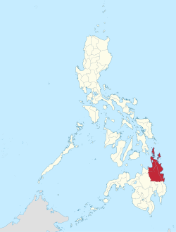 Location in the Philippines | |
| Coordinates: 8°55′N 125°30′E / 8.92°N 125.5°E | |
| Country | Philippines |
| Island group | Mindanao |
| Regional center and largest city | Butuan |
| Area | |
| • Total | 21,478.35 km2 (8,292.84 sq mi) |
| Highest elevation (Mount Hilong-hilong) | 2,012 m (6,601 ft) |
| Population (2020 census)[1] | |
| • Total | 2,804,788 |
| • Density | 130/km2 (340/sq mi) |
| Time zone | UTC+8 (PST) |
| ISO 3166 code | PH-13 |
| Provinces | |
| Cities | |
| Municipalities | 67 |
| Barangays | 1,311 |
| Cong. districts | 7 |
| Languages | |
| GDP (2023) | ₱406.45 billion $7.31 billion[2] |
| Growth rate | |
| HDI | |
| HDI rank | 9th in the Philippines (2019) |
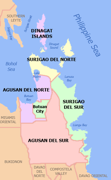
Caraga, officially the Caraga Administrative Region[3] (or simply known as Caraga Region) and designated as Region XIII, is an administrative region in the Philippines occupying the northeastern section of Mindanao. The region was created through Republic Act No. 7901 on February 23, 1995.[3] The region comprises five provinces: Agusan del Norte, Agusan del Sur, Dinagat Islands, Surigao del Norte, and Surigao del Sur;[4] six cities: Bayugan, Bislig, Butuan, Cabadbaran, Surigao and Tandag; 67 municipalities and 1,311 barangays. Butuan, the most urbanized city in Caraga, serves as the regional administrative center.
Etymology
Caraga is named after the Kalagan people (Spanish "Caragan"), a Mansakan subgroup (related to Visayans) native to the regions of Davao and parts of Caraga who speak the Kalagan languages. The name itself is from kalagan (literally " spirited") which means "fierce" or "brave"; from kalag ("spirit" or "soul") in the native animistic anito religions. Hence, the whole Provincia de Caraga of AD 1622 was called region de gente animosa, that is "region of spirited folk".[5]
History
During pre-colonial times, the Rajahnate of Butuan ruled in what is now Agusan del Norte and Butuan. It had much influence on all of Caraga, portions of northern Mindanao, and the western side of Bohol. According to records, Butuan was in conflict with the Sultanate of Ternate in present-day Moluccas of Indonesia. The Ternateans would attack and ransack Butuan and its wealth, but Butuan always prevailed. Butuan had friendly relations with the Rajahnate of Cebu which it considered an ally. It became a powerful Hindu state much known for its goldsmithing and boat-making. Its people used gigantic boats known as balangay which carried numerous men. Relics of these gold crafts and giant boats have been unearthed and preserved by the National Museum of the Philippines and other museums. Butuan also had cordial relations with the Kingdom of Champa in what is now central Vietnam. The Butuan people managed to cross the Sulu Sea and the South China Sea to reach Champa for trade. While the Rajahnate of Butuan was at large, the indigenous lumads of the inner sections of Caraga were free and had their own highly advanced democratic societies, known for their knowledge of nature, medicine, mythology, and warfare. Chinese traders eventually came into Butuan and the Sino-Butuan trade became the focal point of Champa-Butuan relations, where the two nations competed against one another for better trade with the Chinese. Eventually, Butuan started to weaken due to massive attacks from Ternate. Cebu was unable to help at the time because it was also being attacked by Ternate. Likewise, the Kedatuan of Dapitan in Bohol, "The Venice of the Visayas", was also destroyed by an attack from Ternate.
Rajah Siawi and Rajah Kulambo, members of the nobility of the Surigaonon and Butuanon people, respectively, were encountered by the Magellan expedition in 1521 on the island of Limasawa (a hunting ground for the rulers). Antonio Pigafetta describes them as tattooed and covered in gold ornaments. Pigafetta also records the name of the Surigao region as "Calagan". He also describes the "balanghai" (balangay) warships they sailed.[6]: 141–142
When the Spaniards returned and subjugated the Rajahante of Butuan, already weak due to tensions with the Sultanate of Ternate, the boat-making and goldsmithing traditions were eradicated and relations between coastal Butuan and the lumads of the interior became less known. The lumads of the interior were also converted to Christianity, which diminished some of their traditions on nature worship. The Spanish attacked the Sultanate of Ternate to negate any future attacks on Caraga, in which they succeeded, due to their much greater firepower. With the Spaniards having full control of Caraga, they started establishing Spanish-modeled centers to maximize their coverage and control over the territory, in which they succeeded. The Spaniards ruled the country until the United States defeated them in the Spanish-American War which led to the entire archipelago falling into American hands.
The "Kalagan", called "Caragan" by the Spaniards, occurred in the two provinces of Surigao, the northern part of Davao Oriental and eastern Misamis Oriental. In 1635, Caraga was fortified by 45 additional Spanish soldiers and household heads from Mexico, in 1670 a further 81 soldiers, and in 1672 still another 81.[7] By the end of the 1700s, Caraga had 3,497 native families,[8]: 539 [9]: 31, 54, 113 protected by a company of Mexican soldiers.[7] The two Agusan provinces were later organized under the administrative jurisdiction of Surigao and became the independent Agusan province in 1914. In 1960, Surigao was divided into Norte and Sur,[10] and in June 1967, Agusan followed suit.[11] While Butuan then was just a town of Agusan, the logging boom in the 1950s drew business to the area. On August 2, 1950, by virtue of Republic Act 523, the City Charter of Butuan was approved.[12]
In the early years of the Caraga Region, its inhabitants reportedly came from mainland Asia, followed by Malayans, Arabs, Chinese, Japanese, Spanish and Americans. Migrants from the Visayan and Luzon provinces later settled in the area. Most of its inhabitants speak Cebuano and live in rural areas.
On February 23, 1995, the Caraga Region was created through Republic Act No. 7901 in the administration of President Fidel Ramos. The creation of Caraga Region is the revival of the Spanish province of the same name. The provinces of Agusan del Norte, Agusan del Sur and Surigao del Norte (of the former Northern Mindanao region) and Surigao del Sur (of the former Southern Mindanao region) were annexed as part of the newly created region.
Geography
Caraga Region, situated in the northeast section of Mindanao, is between 8 00' to 10 30' N. latitude and 125 15' to 126 30' E. longitude. It is bounded on the north by the Bohol Sea; on the south by the provinces of Davao del Norte, Davao de Oro and Davao Oriental of Region XI; on the west by Bukidnon and Misamis Oriental of Region X; and on the east by the Philippine Sea of the Pacific Ocean.
The region has a total land area of 18,846.97 square kilometres (7,276.86 sq mi), representing 6.3% of the country's total land area and 18.5% of the island of Mindanao. 47.6% of the total land area of the region belongs to the province of Agusan del Sur. Of the total land area, 71.22% is forestland and 28.78% is alienable and disposable land. Major land uses include forestland comprising 31.36% and 23.98% of agricultural and open spaces.
Topography
The region is characterized by mountainous areas, flat and rolling lands. Mountain ranges divide Agusan and Surigao provinces and sub-ranges separate most of the lowlands along the Pacific coast. The most productive agricultural area of the region lies along the Agusan River Basin. The well-known Agusan Marsh sits in the middle of Agusan del Sur. Among the lakes in the region, Lake Mainit is the widest. It traverses eight municipalities: Alegria, Tubod, Mainit and Sison in Surigao del Norte, and Tubay, Santiago, Jabonga and Kitcharao in Agusan del Norte.
Climate
Caraga Region has Type II climate, with no pronounced wet and dry season. During the months of November to February, heavy rains are usually experienced in the region.
Administrative divisions
Provinces
Caraga comprises 5 provinces, 1 highly urbanized city, 5 component cities, 67 municipalities, and 1,311 barangays.
- † Regional center
| Province or HUC | Capital | Population (2015)[1] | Area[13] | Density | Cities | Muni. | Barangay | ||||
|---|---|---|---|---|---|---|---|---|---|---|---|
| km2 | sq mi | /km2 | /sq mi | ||||||||
| Agusan del Norte | Cabadbaran City | 12.1% | 354,503 | 2,730.24 | 1,054.15 | 130 | 340 | 1 | 10 | 167 | |
| Agusan del Sur | Prosperidad | 23.9% | 700,653 | 9,989.52 | 3,856.98 | 70 | 180 | 1 | 13 | 314 | |
| Dinagat Islands | San Jose | 4.3% | 127,152 | 1,036.34 | 400.13 | 120 | 310 | 0 | 7 | 100 | |
| Surigao del Norte | Surigao City | 16.5% | 485,088 | 1,972.93 | 761.75 | 250 | 650 | 1 | 20 | 335 | |
| Surigao del Sur | Tandag | 20.2% | 592,250 | 4,932.70 | 1,904.53 | 120 | 310 | 2 | 17 | 309 | |
| † Butuan | 11.5% | 337,063 | 816.62 | 315.30 | 410 | 1,100 | 86 | ||||
| Total | 2,596,709 | 22,294.97 | 8,608.14 | 120 | 340 | 6 | 67 | 1,311 | |||
|
† Butuan is a highly urbanized city; figures are excluded from Agusan del Norte. | |||||||||||
Governors and vice governors
| Province | Image | Governor | Political Party | Vice Governor | |
|---|---|---|---|---|---|

|
Angelica Amante | PDP–Laban | Rico Corvera | ||

|
Santiago Cane Jr. | NUP | Samuel Tortor | ||

|
Nilo Demerey Jr. | Lakas | Benglen Ecleo | ||

|
Robert Lyndon Barbers | Nacionalista | Eddie Gokiangkee Jr. | ||

|
Alexander Pimentel | PDP–Laban | Manuel Alameda | ||
Demography
| Year | Pop. | ±% p.a. |
|---|---|---|
| 1903 | 115,112 | — |
| 1918 | 166,904 | +2.51% |
| 1939 | 324,918 | +3.22% |
| 1948 | 391,400 | +2.09% |
| 1960 | 631,007 | +4.06% |
| 1970 | 950,129 | +4.17% |
| 1975 | 1,114,336 | +3.25% |
| 1980 | 1,371,512 | +4.24% |
| 1990 | 1,764,297 | +2.55% |
| 1995 | 1,942,687 | +1.82% |
| 2000 | 2,095,367 | +1.64% |
| 2007 | 2,293,346 | +1.25% |
| 2010 | 2,429,224 | +2.12% |
| 2015 | 2,596,709 | +1.28% |
| 2020 | 2,804,788 | +1.53% |
| Source: Philippine Statistics Authority[1][14] | ||
Based on the 2020 census, the total population of the region was 2,933,772. The annual growth rate over this period was over 20%. Among the five provinces, Agusan del Sur registered the largest population at 700,653, and Dinagat Islands was the smallest at 127,152. Surigao del Norte was the fastest growing province with an annual average growth rate of 1.76% over the last five years, while Dinagat Islands was the slowest at 0.05% over the same period.[1]
Butuan and Surigao cities had total populations of 337,063 and 154,137, respectively. Butuan recorded an annual growth rate of 1.62% in the period 2010–2015.[1]
Language
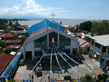
Cebuano is spoken by 33.79% of the households in the region, the language serves as a lingua franca of the region, making it the second language of the majority of residents. Surigaonon is spoken by 33.21% of households, followed by Butuanon with 15%; Kamayo, 7.06%, and Manobo, 4.73%. The rest speak a Boholano dialect of Cebuano, 5.87%; Hiligaynon, 2.87%; and other languages and dialects, 7.20%–these include Ilocano, Kapampangan, Maranao, Maguindanaon and Tausug languages.
Religion
The dominant religion in the region is Roman Catholic, with 74% of the total household population in Caraga. Significant religious minorities include Protestants that constitute 20% of the total household population and Aglipayan that constitute 6% of the total household population.[15]
Cultural groups
The majority of the inhabitants of the region are of Visayan heritage. They are mostly descended from settlers from Cebu, Bohol, Siquijor and Negros Oriental. The province is home to several minority groups, totaling 675,722 in 1995, representing 34.7% of the region's population. Most numerous were the Manobos with 294,284 or 43.55% of the ethnic minorities. Other cultural groups in the region with significant populations were the Kamayos, Higaonons, Banwaons, Umayamnons, Kalagans, and Mamanwas. Other significant minority residents in the province include:
Most members of these cultural groups reside in the province of Agusan del Sur.
Economy
Poverty incidence of Caraga


