A | B | C | D | E | F | G | H | CH | I | J | K | L | M | N | O | P | Q | R | S | T | U | V | W | X | Y | Z | 0 | 1 | 2 | 3 | 4 | 5 | 6 | 7 | 8 | 9
Bucks County | |
|---|---|
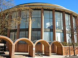
 Bucks County Administration Building in Doylestown in 2010 | |
|
| |
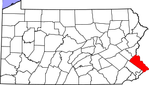
 Location within the U.S. state of Pennsylvania | |
 Pennsylvania's location within the U.S. | |
| Coordinates: 40°20′N 75°07′W / 40.34°N 75.11°W | |
| Country | |
| State | |
| Founded | November 1682 |
| Named for | Buckinghamshire |
| Seat | Doylestown |
| Largest township | Bensalem |
| Area | |
| • Total | 622 sq mi (1,610 km2) |
| • Land | 604 sq mi (1,560 km2) |
| • Water | 18 sq mi (50 km2) 2.8% |
| Population (2020) | |
| • Total | 646,538 |
| • Density | 1,070/sq mi (410/km2) |
| Time zone | UTC−5 (Eastern) |
| • Summer (DST) | UTC−4 (EDT) |
| Congressional district | 1st |
| Website | www |
| Designated | October 29, 1982[1] |
Bucks County is a county in the Commonwealth of Pennsylvania. As of the 2020 census, the population was 646,538,[2] making it the fourth-most populous county in Pennsylvania. Its county seat is Doylestown.[3] The county is named after the English county of Buckinghamshire. The county is part of the Southeast Pennsylvania region of the state.[a]
The county represents the northern boundary of the Philadelphia–Camden–Wilmington, PA–NJ–DE–MD Metropolitan Statistical Area, known as the Delaware Valley.
To its southwest, Bucks County borders Montgomery County and Philadelphia, the nation's sixth-largest city. To its east, the county borders the Delaware River and U.S. state of New Jersey. To its north, the county borders Lehigh and Northampton counties in the state's Lehigh Valley region. The county is approximately 30 miles (48 km) southeast of Allentown, the state's third-largest city, and 40 miles (64 km) north of Philadelphia, the state's largest city.
History
Founding

Bucks County is one of the three original counties created by colonial proprietor William Penn in 1682. Penn named the county after Buckinghamshire, the county in which he lived in England; "Bucks." is the traditional abbreviation for the English county, which became the actual name of the Pennsylvania one. He built a country estate, Pennsbury Manor, in Falls Township in present-day Bucks County.
Some places in Bucks County were named after locations in Buckinghamshire, England, including Buckingham and Buckingham Township, named after the former county town of Buckinghamshire; Chalfont, named after Chalfont St Giles, the parish home of William Penn's first wife and the location of the Jordans Quaker Meeting House, where Penn is buried; Solebury, named after Soulbury, England; and Wycombe, named after the town of High Wycombe.
Bucks County was originally much larger than it is today. Northampton County was formed in 1752 from part of Bucks County, and Lehigh County was formed in 1812 from part of Northampton County.
American Revolutionary War
General George Washington and his troops camped in Bucks County as they prepared to cross the Delaware River to take Trenton, New Jersey, by surprise on the morning of December 26, 1776. Their successful attack on Britain's Hessian forces was a turning point in the American Revolutionary War. The town of Washington Crossing, Pennsylvania and Washington Crossing Historic Park were named to commemorate the event.
Geography
According to the U.S. Census Bureau, the county has a total area of 622 square miles (1,610 km2), of which 604 square miles (1,560 km2) is land and 18 square miles (47 km2) (2.8%) is water.[4]
The southern third of the county between Philadelphia and Trenton, New Jersey, often called Lower Bucks, resides in the Atlantic Coastal Plain; it is flat and near sea level, and is the county's most populated and industrialized area.
Bucks County shares a western border with Montgomery County, and also borders Philadelphia to the southwest, and Northampton and Lehigh Counties to the north. From north to south, it is linked to Warren, Hunterdon, Mercer and Burlington Counties in New Jersey by bridges.
Tohickon Creek and Neshaminy Creek are the largest tributaries of the Delaware in Bucks County. Tohickon Creek empties into the river at Point Pleasant and Neshaminy at Croydon (Bristol Township).
Adjacent counties
- Lehigh County (northwest)
- Northampton County (north)
- Warren County, New Jersey (northeast)
- Hunterdon County, New Jersey (northeast)
- Mercer County, New Jersey (east)
- Burlington County, New Jersey (southeast)
- Philadelphia County (south)
- Montgomery County (west)
Demographics
| Census | Pop. | Note | %± |
|---|---|---|---|
| 1790 | 25,216 | — | |
| 1800 | 27,496 | 9.0% | |
| 1810 | 32,371 | 17.7% | |
| 1820 | 37,842 | 16.9% | |
| 1830 | 45,745 | 20.9% | |
| 1840 | 48,107 | 5.2% | |
| 1850 | 56,091 | 16.6% | |
| 1860 | 63,578 | 13.3% | |
| 1870 | 64,336 | 1.2% | |
| 1880 | 68,656 | 6.7% | |
| 1890 | 70,615 | 2.9% | |
| 1900 | 71,190 | 0.8% | |
| 1910 | 76,530 | 7.5% | |
| 1920 | 82,476 | 7.8% | |
| 1930 | 96,727 | 17.3% | |
| 1940 | 107,715 | 11.4% | |
| 1950 | 144,620 | 34.3% | |
| 1960 | 308,567 | 113.4% | |
| 1970 | 410,056 | 32.9% | |
| 1980 | 479,211 | 16.9% | |
| 1990 | 541,174 | 12.9% | |
| 2000 | 597,635 | 10.4% | |
| 2010 | 625,249 | 4.6% | |
| 2020 | 646,538 | 3.4% | |
| U.S. Decennial Census[5] 1790-1960[6] 1900-1990[7] 1990-2000[8] 2010-2019[9] | |||
As of the 2010 census, there were 625,249 people. The population density was 1,034.7 people per square mile. The racial makeup of the county was 86.6% Non-Hispanic white, 3.9% Black or African American, 0.3% Native American, 4.1% Asian (2.1% Indian, 1.1% Chinese, 0.7% Korean, 0.5% Filipino, 0.3% Vietnamese, 0.1% Japanese, 0.4% other Asian) 0.1% Pacific Islander, 1.7% were of two or more races, and 1.5% were of other races. 4.4% of the population were Hispanic or Latino of any race.
As of the census[10] of 2000, there were 218,725 households, and 160,981 families residing in the county. There were 225,498 housing units at an average density of 371 per square mile (143/km2). 20.1% were of German, 19.1% Irish, 14.0% Italian, 7.5% English and 5.9% Polish ancestry.
There were 218,725 households, out of which 35.30% had children under the age of 18 living with them, 61.20% were married couples living together, 8.80% had a female householder with no husband present, and 26.40% were non-families. 21.50% of all households were made up of individuals, and 8.10% had someone living alone who was 65 years of age or older. The average household size was 2.69 and the average family size was 3.17.
In the county, the population was spread out, with 25.70% under the age of 18, 7.00% from 18 to 24, 30.70% from 25 to 44, 24.30% from 45 to 64, and 12.40% who were 65 years of age or older. The median age was 38 years. For every 100 females there were 96.30 males. For every 100 females age 18 and over, there were 93.40 males.
The median income for a household in the county was $59,727, and the median income for a family was $68,727. Males had a median income of $46,587 versus $31,984 for females. The per capita income for the county was $27,430. About 3.10% of families and 4.50% of the population were below the poverty line, including 4.80% of those under age 18 and 5.50% of those age 65 or over.
Population growth
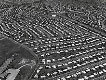
Growth began in the early 1950s, when William Levitt chose Bucks County for his second "Levittown". Levitt bought hundreds of acres of woodlands and farmland, and constructed 17,000 homes and dozens of schools, parks, libraries, and shopping centers. By the time the project was completed, the population of Levittown had swelled to nearly 74,000 residents. At the time, only whites could buy homes. This rule however, was soon overturned. Other planned developments included Croydon and Fairless Hills. This rapid sprawl continued until the mid-1960s.
In the 1970s, the county experienced a second growth spurt as developers expanded in previously underdeveloped townships, including Middletown, Lower Makefield, Northampton, and Newtown townships. Tract housing, office complexes, shopping centers, and sprawling parking lots continued to move more and more towards Upper Bucks, swallowing horse farms, sprawling forests, and wetlands. Oxford Valley Mall was constructed in Middletown, and became a retail nucleus in the county.
In the late 20th century, growth somewhat stabilized as development was completed in the county's historically underdeveloped areas, leaving little new area to be further developed.
Bucks County areas along the Delaware River have surpluses of abandoned industry, so many municipalities have granted building rights to luxury housing developers. As the regions that began the suburban boom in Bucks County, such as Levittown, have aged, commercial strips and other neglected structures have been torn down and replaced with new shopping plazas and commercial chains. With rising property values, areas with older construction are undergoing a renaissance, and Central and Upper Bucks have continued to experience rapid growth, with many municipalities doubling their populations since the late 20th century.
As of 2013, the population of Bucks County was 626,976, making it the fourth-most populous county county in the state behind Philadelphia, Allegheny, and Montgomery counties.[9]
2020 census
| Race | Num. | Perc. |
|---|---|---|
| White (NH) | 521,575 | 80.67% |
| Black or African American (NH) | 25,277 | 4% |
| Native American (NH) | 531 | 0.08% |
| Asian (NH) | 35,053 | 5.42% |
| Pacific Islander (NH) | 143 | 0.02% |
| Other/Mixed (NH) | 24,189 | 3.74% |
| Hispanic or Latino | 39,770 | 6.15% |
Economy

The boroughs of Bristol and Morrisville were prominent industrial centers along the Northeast Corridor during World War II. Suburban development accelerated in Lower Bucks in the 1950s with the opening of Levittown, Pennsylvania, the second such "Levittown" designed by William Levitt.
Among Bucks' largest employers in the twentieth century were U.S. Steel in Falls Township, and the Vulcanized Rubber & Plastics and Robertson Tile companies in Morrisville. Rohm and Haas continues to operate several chemical plants around Bristol. Waste Management operates a landfill in Tullytown that is the largest receptacle of out-of-state waste in the USA (receiving much of New York City's waste following the closure of Fresh Kills landfill in Staten Island, NY 40 miles (64 km) away).[citation needed]
Bucks is also experiencing rapid growth in biotechnology, along with neighboring Montgomery County. The Greater Philadelphia area consistently ranks in the top 10 geographic clusters for biotechnology and biopharma.[12] It is projected by 2020 that one out of four people in Bucks County will work in biotechnology.
Notable businesses
- 21st Century Media
- Burpee Seeds and Plants
- Byers' Choice Ltd.
- Carson Helicopters
- Charming Shoppes
- eGames, Inc.
- EPAM Systems
- GE Betz
- Keystone Aircraft
- V. La Rosa and Sons Macaroni Company
- Lehigh Defense
- McCaffrey's Food Markets
- Moon Nurseries
- New Hope and Ivyland Railroad
- Questar Corporation
- Rita's Italian Ice
- Simpay
- West Coast Video
- Windowizards
Tourism


Another important asset of the county is tourism. The county's northern regions, colloquially referred to as Upper Bucks, are known for their natural scenery, farmland, colonial history, and proximity to major urban areas, including Philadelphia, New York City, Allentown, Reading, and Atlantic City, each of which is within a two-hour driving radius.
Bucks County is home to twelve covered bridges. Ten are still open to vehicular traffic; two others, located in parks, are open only to non-vehicular traffic. All Bucks County bridges use the Town truss design. Schofield Ford Bridge, in Tyler State Park, was reconstructed in 1997 from the ground up after arsonists destroyed the original in 1991.[13]
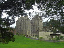
Popular attractions in Bucks County include the shops and studios of New Hope, Peddler's Village (in Lahaska), Washington Crossing Historic Park, New Hope Railroad, Bucks County River Country and Bucks County Playhouse Theater (in New Hope). Rice's Market near Lahaska is a popular destination on Tuesday mornings. Quakertown Farmer's Market (locally called "Q-Mart") is a popular shopping destination on weekends. The county seat of Doylestown has the trifecta of concrete structures built by Henry Chapman Mercer, including the Moravian Pottery and Tile Works, the Mercer Museum and Fonthill, Mercer's personal home.
Southern Bucks, colloquially referred to as Lower Bucks, is home to two important shopping malls, Neshaminy Mall, Oxford Valley Mall, and Sesame Place, a family theme park based on the Sesame Street television series. Also within Lower Bucks County is Parx Casino and Racing in Bensalem, a casino and thoroughbred horse racing track. The casino was built on the grounds of what was originally Philadelphia Park Racetrack. The complex includes the thoroughbred horse racing track, expansive casino, a dance club, numerous dining options, and the Xcite Center.
Education
Colleges and universities
- Bucks County Community College
- Delaware Valley University in Doylestown
- Cairn University in Langhorne Manor Zdroj:https://en.wikipedia.org?pojem=Bucks_County
Text je dostupný za podmienok Creative Commons Attribution/Share-Alike License 3.0 Unported; prípadne za ďalších podmienok. Podrobnejšie informácie nájdete na stránke Podmienky použitia.
Antropológia
Aplikované vedy
Bibliometria
Dejiny vedy
Encyklopédie
Filozofia vedy
Forenzné vedy
Humanitné vedy
Knižničná veda
Kryogenika
Kryptológia
Kulturológia
Literárna veda
Medzidisciplinárne oblasti
Metódy kvantitatívnej analýzy
Metavedy
Metodika
Text je dostupný za podmienok Creative
Commons Attribution/Share-Alike License 3.0 Unported; prípadne za ďalších
podmienok.
Podrobnejšie informácie nájdete na stránke Podmienky
použitia.
www.astronomia.sk | www.biologia.sk | www.botanika.sk | www.dejiny.sk | www.economy.sk | www.elektrotechnika.sk | www.estetika.sk | www.farmakologia.sk | www.filozofia.sk | Fyzika | www.futurologia.sk | www.genetika.sk | www.chemia.sk | www.lingvistika.sk | www.politologia.sk | www.psychologia.sk | www.sexuologia.sk | www.sociologia.sk | www.veda.sk I www.zoologia.sk


