

A | B | C | D | E | F | G | H | CH | I | J | K | L | M | N | O | P | Q | R | S | T | U | V | W | X | Y | Z | 0 | 1 | 2 | 3 | 4 | 5 | 6 | 7 | 8 | 9
Boston | |
|---|---|
Downtown from Boston Harbor Acorn Street on Beacon Hill Fenway Park during a Boston Red Sox game Back Bay from the Charles River | |
 Seal  Coat of arms Wordmark | |
| Nickname(s): Bean Town, Title Town, others | |
| Motto(s): Sicut patribus sit Deus nobis (Latin) 'As God was with our fathers, so may He be with us' | |
    | |
 Boston  Boston  Boston  Boston | |
| Coordinates: 42°21′37″N 71°3′28″W / 42.36028°N 71.05778°W | |
| Country | United States |
| Region | New England |
| State | Massachusetts |
| County | Suffolk[1]
|
| Historic countries | Kingdom of England Commonwealth of England Kingdom of Great Britain |
| Historic colonies | Massachusetts Bay Colony, Dominion of New England, Province of Massachusetts Bay |
| Settled | 1625 |
| Incorporated (town) | September 7, 1630 (date of naming, Old Style) September 17, 1630 (date of naming, New Style) |
| Incorporated (city) | March 19, 1822 |
| Named for | Boston, Lincolnshire |
| Government | |
| • Type | Strong mayor / Council |
| • Mayor | Michelle Wu (D) |
| • Council | Boston City Council |
| • Council President | Ruthzee Louijeune (D) |
| Area | |
| • State capital city | 89.61 sq mi (232.10 km2) |
| • Land | 48.34 sq mi (125.20 km2) |
| • Water | 41.27 sq mi (106.90 km2) |
| • Urban | 1,655.9 sq mi (4,288.7 km2) |
| • Metro | 4,500 sq mi (11,700 km2) |
| • CSA | 10,600 sq mi (27,600 km2) |
| Elevation | 46 ft (14 m) |
| Population | |
| • State capital city | 675,647 |
| • Estimate (2021)[4] | 654,776 |
| • Rank | 66th in North America 24th in the United States 1st in Massachusetts |
| • Density | 13,976.98/sq mi (5,396.51/km2) |
| • Urban | 4,382,009 (US: 10th) |
| • Urban density | 2,646.3/sq mi (1,021.8/km2) |
| • Metro | 4,941,632 (US: 10th) |
| Demonym | Bostonian |
| GDP | |
| • Boston (MSA) | $571.6 billion (2022) |
| Time zone | UTC−5 (EST) |
| • Summer (DST) | UTC−4 (EDT) |
| ZIP Codes | 53 ZIP Codes[8]
|
| Area codes | 617 and 857 |
| FIPS code | 25-07000 |
| GNIS feature ID | 617565 |
| Website | boston |
.jpg)

.jpg)
.jpg)


Boston (US: /ˈbɔːstən/[9]), officially the City of Boston, is the capital and most populous city in the Commonwealth of Massachusetts in the United States. The city serves as the cultural and financial center of the New England region of the Northeastern United States. It has an area of 48.4 sq mi (125 km2)[10] and a population of 675,647 as of the 2020 census, making it the third-largest city in the Northeast after New York City and Philadelphia.[4] The Greater Boston metropolitan statistical area, including and surrounding the city, is the largest in New England and eleventh-largest in the country.[11][12][13]
Boston was founded on the Shawmut Peninsula in 1630 by Puritan settlers. The city was named after Boston, Lincolnshire, England.[14][15] During the American Revolution, Boston was home to several events that proved central to the revolution and subsequent Revolutionary War, including the Boston Massacre (1770), the Boston Tea Party (1773), Paul Revere's Midnight Ride (1775), the Battle of Bunker Hill (1775), and the Siege of Boston (1775–1776). Following American independence from Great Britain, the city continued to play an important role as a port, manufacturing hub, and center for education and culture.[16][17]
The city expanded significantly beyond the original peninsula by filling in land and annexing neighboring towns. It now attracts many tourists, with Faneuil Hall alone drawing more than 20 million visitors per year.[18] Boston's many firsts include the United States' first public park (Boston Common, 1634),[19] the first public school (Boston Latin School, 1635),[20] and the first subway system (Tremont Street subway, 1897).[21]
Since the nation's founding, Boston has been a national leader in higher education and research. Boston University and Northeastern University are both located within the city, with Boston College located in nearby Chestnut Hill, Massachusetts. Two of the world's most prestigious and consistently highly ranked universities, Harvard University (the nation's oldest university) and the Massachusetts Institute of Technology, are both located in neighboring Cambridge, Massachusetts.[22]
Boston has emerged as the largest biotechnology hub in the world.[23] The city is also a national leader in scientific research, law, medicine, engineering, and business. With nearly 5,000 startup companies, the city is considered a global pioneer in innovation and entrepreneurship,[24][25][26] and more recently in artificial intelligence.[27] Boston's economy also includes finance,[28] professional and business services, information technology, and government activities.[29] Households in the city claim the highest average rate of philanthropy in the United States.[30] Furthermore, Boston's businesses and institutions rank among the top in the country overall for environmental sustainability and new investment.[31]
History
Indigenous era
Prior to European colonization, the region surrounding present-day Boston was inhabited by the Massachusett people who had small, seasonal communities.[32][33] When a group of settlers led by John Winthrop arrived in 1630, the Shawmut Peninsula was nearly empty of the Native people, as many had died of European diseases brought by early settlers and traders.[34][35] Archaeological excavations unearthed one of the oldest fishweirs in New England on Boylston Street, which Native people constructed as early as 7,000 years before European arrival in the Western Hemisphere.[33][32][36]
Settlement by Europeans
The first European to live in what would become Boston was a Cambridge-educated Anglican cleric named William Blaxton. He was the person most directly responsible for the foundation of Boston by Puritan colonists in 1630. This occurred after Blaxton invited one of their leaders, Isaac Johnson, to cross Back Bay from the failing colony of Charlestown and share the peninsula. The Puritans made the crossing in September 1630.[37][38][39]
The name "Boston"
Before Johnson died on September 30, 1630, he named their then-new settlement across the river "Boston". (This was one of his last official acts as the leader of the Charlestown community.) The settlement's name came from Johnson's hometown of Boston, Lincolnshire, from which he, his wife (namesake of the Arbella) and John Cotton (grandfather of Cotton Mather) had emigrated to New England. The name of the English town ultimately derives from its patron saint, St. Botolph, in whose church John Cotton served as the rector until his emigration with Johnson. In early sources, Lincolnshire's Boston was known as "St. Botolph's town", later contracted to "Boston". Before this renaming, the settlement on the peninsula had been known as "Shawmut" by Blaxton and "Tremontaine"[40] by the Puritan settlers he had invited.[41][42][43][44][45]
Puritan occupation
Puritan influence on Boston began even before the settlement was founded with the 1629 Cambridge Agreement. This document created the Massachusetts Bay Colony and was signed by its first governor John Winthrop. Puritan ethics and their focus on education also influenced the early history of the city. America's first public school, Boston Latin School, was founded in Boston in 1635.[20][46]
Boston was the largest town in the Thirteen Colonies until Philadelphia outgrew it in the mid-18th century.[47] Boston's oceanfront location made it a lively port, and the then-town primarily engaged in shipping and fishing during its colonial days. Boston was a primary stop on a Caribbean trade route and imported large amounts of molasses, which led to the creation of Boston baked beans.[48]
Boston's economy stagnated in the decades prior to the Revolution. By the mid-18th century, New York City and Philadelphia surpassed Boston in wealth. During this period, Boston encountered financial difficulties even as other cities in New England grew rapidly.[49][50]
Revolution and the siege of Boston


The weather continuing boisterous the next day and night, giving the enemy time to improve their works, to bring up their cannon, and to put themselves in such a state of defence, that I could promise myself little success in attacking them under all the disadvantages I had to encounter.
William Howe, 5th Viscount Howe, in a letter to William Legge, 2nd Earl of Dartmouth, about the British army's decision to leave Boston, dated March 21, 1776.[51]
Many crucial events of the American Revolution[52] occurred in or near Boston. The then-town's mob presence, along with the colonists' growing lack of faith in either Britain or its Parliament, fostered a revolutionary spirit there.[49] When the British parliament passed the Stamp Act in 1765, a Boston mob ravaged the homes of Andrew Oliver, the official tasked with enforcing the Act, and Thomas Hutchinson, then the Lieutenant Governor of Massachusetts.[49][53] The British sent two regiments to Boston in 1768 in an attempt to quell the angry colonists. This did not sit well with the colonists, however. In 1770, during the Boston Massacre, British troops shot into a crowd that had started to violently harass them. The colonists compelled the British to withdraw their troops. The event was widely publicized and fueled a revolutionary movement in America.[50]
In 1773, Parliament passed the Tea Act. Many of the colonists saw the act as an attempt to force them to accept the taxes established by the Townshend Acts. The act prompted the Boston Tea Party, where a group of angered Bostonians threw an entire shipment of tea sent by the East India Company into Boston Harbor. The Boston Tea Party was a key event leading up to the revolution, as the British government responded furiously with the Coercive Acts, demanding compensation for the destroyed tea from the Bostonians.[49] This angered the colonists further and led to the American Revolutionary War. The war began in the area surrounding Boston with the Battles of Lexington and Concord.[49][54]
Boston itself was besieged for almost a year during the siege of Boston, which began on April 19, 1775. The New England militia impeded the movement of the British Army. Sir William Howe, then the commander-in-chief of the British forces in North America, led the British army in the siege. On June 17, the British captured Charlestown (now part of Boston) during the Battle of Bunker Hill. The British army outnumbered the militia stationed there, but it was a pyrrhic victory for the British because their army suffered irreplaceable casualties. It was also a testament to the skill and training of the militia, as their stubborn defense made it difficult for the British to capture Charlestown without suffering further irreplaceable casualties.[55][56]
Several weeks later, George Washington took over the militia after the Continental Congress established the Continental Army to unify the revolutionary effort. Both sides faced difficulties and supply shortages in the siege, and the fighting was limited to small-scale raids and skirmishes. The narrow Boston Neck, which at that time was only about a hundred feet wide, impeded Washington's ability to invade Boston, and a long stalemate ensued. A young officer, Rufus Putnam, came up with a plan to make portable fortifications out of wood that could be erected on the frozen ground under cover of darkness. Putnam supervised this effort, which successfully installed both the fortifications and dozens of cannons on Dorchester Heights that Henry Knox had laboriously brought through the snow from Fort Ticonderoga. The astonished British awoke the next morning to see a large array of cannons bearing down on them. General Howe is believed to have said that the Americans had done more in one night than his army could have done in six months. The British Army attempted a cannon barrage for two hours, but their shot could not reach the colonists' cannons at such a height. The British gave up, boarded their ships, and sailed away. This has become known as "Evacuation Day", which Boston still celebrates each year on March 17. After this, Washington was so impressed that he made Rufus Putnam his chief engineer.[54][55][57]
Post-revolution and the War of 1812


After the Revolution, Boston's long seafaring tradition helped make it one of the nation's busiest ports for both domestic and international trade. Boston's harbor activity was significantly curtailed by the Embargo Act of 1807 (adopted during the Napoleonic Wars) and the War of 1812. Foreign trade returned after these hostilities, but Boston's merchants had found alternatives for their capital investments in the meantime. Manufacturing became an important component of the city's economy, and the city's industrial manufacturing overtook international trade in economic importance by the mid-19th century. The small rivers bordering the city and connecting it to the surrounding region facilitated shipment of goods and led to a proliferation of mills and factories. Later, a dense network of railroads furthered the region's industry and commerce.[58]
During this period, Boston flourished culturally as well. It was admired for its rarefied literary life and generous artistic patronage.[59][60] Members of old Boston families—eventually dubbed the Boston Brahmins—came to be regarded as the nation's social and cultural elites.[61] They are often associated with the American upper class, Harvard University,[62] and the Episcopal Church.[63][64]
Boston was an early port of the Atlantic triangular slave trade in the New England colonies, but was soon overtaken by Salem, Massachusetts and Newport, Rhode Island.[65] Boston eventually became a center of the abolitionist movement.[66] The city reacted strongly to the Fugitive Slave Act of 1850,[67] contributing to President Franklin Pierce's attempt to make an example of Boston after the Anthony Burns Fugitive Slave Case.[68][69]
In 1822,[16] the citizens of Boston voted to change the official name from the "Town of Boston" to the "City of Boston", and on March 19, 1822, the people of Boston accepted the charter incorporating the city.[70] At the time Boston was chartered as a city, the population was about 46,226, while the area of the city was only 4.8 sq mi (12 km2).[70]
19th century
In the 1820s, Boston's population grew rapidly, and the city's ethnic composition changed dramatically with the first wave of European immigrants. Irish immigrants dominated the first wave of newcomers during this period, especially following the Great Famine; by 1850, about 35,000 Irish lived in Boston.[71] In the latter half of the 19th century, the city saw increasing numbers of Irish, Germans, Lebanese, Syrians,[72] French Canadians, and Russian and Polish Jews settling there. By the end of the 19th century, Boston's core neighborhoods had become enclaves of ethnically distinct immigrants with their residence yielding lasting cultural change. Italians became the largest inhabitants of the North End,[73] Irish dominated South Boston and Charlestown, and Russian Jews lived in the West End. Irish and Italian immigrants brought with them Roman Catholicism. Currently, Catholics make up Boston's largest religious community,[74] and the Irish have played a major role in Boston politics since the early 20th century; prominent figures include the Kennedys, Tip O'Neill, and John F. Fitzgerald.[75]
Between 1631 and 1890, the city tripled its area through land reclamation by filling in marshes, mud flats, and gaps between wharves along the waterfront. Reclamation projects in the middle of the century created significant parts of the South End, the West End, the Financial District, and Chinatown.[76]
After the Great Boston fire of 1872, workers used building rubble as landfill along the downtown waterfront. During the mid-to-late 19th century, workers filled almost 600 acres (240 ha) of brackish Charles River marshlands west of Boston Common with gravel brought by rail from the hills of Needham Heights. The city annexed the adjacent towns of South Boston (1804), East Boston (1836), Roxbury (1868), Dorchester (including present-day Mattapan and a portion of South Boston) (1870), Brighton (including present-day Allston) (1874), West Roxbury (including present-day Jamaica Plain and Roslindale) (1874), Charlestown (1874), and Hyde Park (1912).[77][78] Other proposals were unsuccessful for the annexation of Brookline, Cambridge,[79] and Chelsea.[80][81]
-
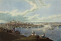 Downtown Boston from Dorchester Heights in 1841
 -
 Tremont Street in 1843
 -
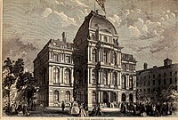 The Old City Hall was home to the Boston city council from 1865 to 1969.
 -
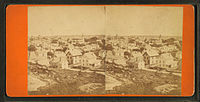 View of Boston by J. J. Hawes, c. 1860s–1880s
 -
 Haymarket Square in 1909


_(14578749118).jpg)


20th century
Fenway Park, home of the Boston Red Sox, opened in 1912.[82]
Many architecturally significant buildings were built during these early years of the 20th century: Horticultural Hall,[83] the Tennis and Racquet Club,[84] Isabella Stewart Gardner Museum,[85] Fenway Studios,[86] Jordan Hall,[87] and the Boston Opera House. The Longfellow Bridge,[88] built in 1906, was mentioned by Robert McCloskey in Make Way for Ducklings, describing its "salt and pepper shakers" feature.[89]
Logan International Airport opened on September 8, 1923.[90] The Boston Bruins were founded in 1924 and played their first game at Boston Garden in November 1928.[91]
Boston went into decline by the early to mid-20th century, as factories became old and obsolete and businesses moved out of the region for cheaper labor elsewhere.[92] Boston responded by initiating various urban renewal projects, under the direction of the Boston Redevelopment Authority (BRA) established in 1957. In 1958, BRA initiated a project to improve the historic West End neighborhood. Extensive demolition was met with strong public opposition, and thousands of families were displaced.[93]
The BRA continued implementing eminent domain projects, including the clearance of the vibrant Scollay Square area for construction of the modernist style Government Center. In 1965, the Columbia Point Health Center opened in the Dorchester neighborhood, the first Community Health Center in the United States. It mostly served the massive Columbia Point public housing complex adjoining it, which was built in 1953. The health center is still in operation and was rededicated in 1990 as the Geiger-Gibson Community Health Center.[94] The Columbia Point complex itself was redeveloped and revitalized from 1984 to 1990 into a mixed-income residential development called Harbor Point Apartments.[95]
By the 1970s, the city's economy had begun to recover after 30 years of economic downturn. A large number of high-rises were constructed in the Financial District and in Boston's Back Bay during this period.[96] This boom continued into the mid-1980s and resumed after a few pauses. Hospitals such as Massachusetts General Hospital, Beth Israel Deaconess Medical Center, and Brigham and Women's Hospital lead the nation in medical innovation and patient care. Schools such as the Boston Architectural College, Boston College, Boston University, the Harvard Medical School, Tufts University School of Medicine, Northeastern University, Massachusetts College of Art and Design, Wentworth Institute of Technology, Berklee College of Music, the Boston Conservatory, and many others attract students to the area. Nevertheless, the city experienced conflict starting in 1974 over desegregation busing, which resulted in unrest and violence around public schools throughout the mid-1970s.[97]
21st century

Boston is an intellectual, technological, and political center. However, it has lost some important regional institutions,[98] including the loss to mergers and acquisitions of local financial institutions such as FleetBoston Financial, which was acquired by Charlotte-based Bank of America in 2004.[99] Boston-based department stores Jordan Marsh and Filene's have both merged into the New York City–based Macy's.[100] The 1993 acquisition of The Boston Globe by The New York Times[101] was reversed in 2013 when it was re-sold to Boston businessman John W. Henry. In 2016, it was announced General Electric would be moving its corporate headquarters from Connecticut to the Seaport District in Boston, joining many other companies in this rapidly developing neighborhood.
Boston has experienced gentrification in the latter half of the 20th century,[102] with housing prices increasing sharply since the 1990s when the city's rent control regime was struck down by statewide ballot proposition.[103]
On April 15, 2013, two Chechen Islamist brothers detonated a pair of bombs near the finish line of the Boston Marathon, killing three people and injuring roughly 264.[104]
In 2016, Boston briefly shouldered a bid as the U.S. applicant for the 2024 Summer Olympics. The bid was supported by the mayor and a coalition of business leaders and local philanthropists, but was eventually dropped due to public opposition.[105] The USOC then selected Los Angeles to be the American candidate with Los Angeles ultimately securing the right to host the 2028 Summer Olympics.[106]
Geography


Boston has an area of 89.63 sq mi (232.1 km2). Of this area, 48.4 sq mi (125.4 km2), or 54%, of it is land and 41.2 sq mi (106.7 km2), or 46%, of it is water. The city's official elevation, as measured at Logan International Airport, is 19 ft (5.8 m) above sea level.[107] The highest point in Boston is Bellevue Hill at 330 ft (100 m) above sea level, and the lowest point is at sea level.[108] Boston is situated next to Boston Harbor, an arm of Massachusetts Bay, itself an arm of the Atlantic Ocean.
The geographical center of Boston is in Roxbury. Due north of the center we find the South End. This is not to be confused with South Boston which lies directly east from the South End. North of South Boston is East Boston and southwest of East Boston is the North End.[This quote needs a citation]
— author, Unknown – A local colloquialism
Boston is surrounded by the Greater Boston metropolitan region. It is bordered to the east by the town of Winthrop and the Boston Harbor Islands, to the northeast by the cities of Revere, Chelsea and Everett, to the north by the cities of Somerville and Cambridge, to the northwest by Watertown, to the west by the city of Newton and town of Brookline, to the southwest by the town of Dedham and small portions of Needham and Canton, and to the southeast by the town of Milton, and the city of Quincy.
The Charles River separates Boston's Allston-Brighton, Fenway-Kenmore and Back Bay neighborhoods from Watertown and Cambridge, and most of Boston from its own Charlestown neighborhood. The Neponset River forms the boundary between Boston's southern neighborhoods and Quincy and Milton. The Mystic River separates Charlestown from Chelsea and Everett, and Chelsea Creek and Boston Harbor separate East Boston from Downtown, the North End, and the Seaport.[109]
Neighborhoods

Boston is sometimes called a "city of neighborhoods" because of the profusion of diverse subsections.[110][111] The city government's Office of Neighborhood Services has officially designated 23 neighborhoods:[112]
More than two-thirds of inner Boston's modern land area did not exist when the city was founded. Instead, it was created via the gradual filling in of the surrounding tidal areas over the centuries.[76] This was accomplished using earth from the leveling or lowering of Boston's three original hills (the "Trimountain", after which Tremont Street is named), as well as with gravel brought by train from Needham to fill the Back Bay.[17]
Downtown and its immediate surroundings (including the Financial District, Government Center, and South Boston) consist largely of low-rise masonry buildings – often federal style and Greek revival – interspersed with modern high-rises.[113] Back Bay includes many prominent landmarks, such as the Boston Public Library, Christian Science Center, Copley Square, Newbury Street, and New England's two tallest buildings: the John Hancock Tower and the Prudential Center.[114] Near the John Hancock Tower is the old John Hancock Building with its prominent illuminated beacon, the color of which forecasts the weather.[115] Smaller commercial areas are interspersed among areas of single-family homes and wooden/brick multi-family row houses. The South End Historic District is the largest surviving contiguous Victorian-era neighborhood in the US.[116]
The geography of downtown and South Boston was particularly affected by the Central Artery/Tunnel Project (which ran from 1991 to 2007, and was known unofficially as the "Big Dig"). That project removed the elevated Central Artery and incorporated new green spaces and open areas.[117]
Climate
-
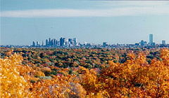 Boston's skyline in the background with fall foliage in the foreground
 -
 A graph of cumulative winter snowfall at Logan International Airport from 1938 to 2015. The four winters with the most snowfall are highlighted. The snowfall data, which was collected by NOAA, is from the weather station at the airport.


Under the Köppen climate classification, Boston has either a hot-summer humid continental climate (Köppen Dfa) under the 0 °C (32.0 °F) isotherm or a humid subtropical climate (Köppen Cfa) under the −3 °C (26.6 °F) isotherm.[118] Summers are warm to hot and humid, while winters are cold and stormy, with occasional periods of heavy snow. Spring and fall are usually cool and mild, with varying conditions dependent on wind direction and the position of the jet stream. Prevailing wind patterns that blow offshore minimize the influence of the Atlantic Ocean. However, in winter, areas near the immediate coast often see more rain than snow, as warm air is sometimes drawn off the Atlantic.[119] The city lies at the border between USDA plant hardiness zones 6b (away from the coastline) and 7a (close to the coastline).[120]
The hottest month is July, with a mean temperature of 74.1 °F (23.4 °C). The coldest month is January, with a mean temperature of 29.9 °F (−1.2 °C). Periods exceeding 90 °F (32 °C) in summer and below freezing in winter are not uncommon but tend to be fairly short, with about 13 and 25 days per year seeing each, respectively.[121]
Sub- 0 °F (−18 °C) readings usually occur every 3 to 5 years.[122] The most recent sub- 0 °F (−18 °C) reading occurred on February 4, 2023, when the temperature dipped down to −10 °F (−23 °C); this was the lowest temperature reading in the city since 1957.[121] In addition, several decades may pass between 100 °F (38 °C) readings; the last such reading occurred on July 24, 2022.[121] The city's average window for freezing temperatures is November 9 through April 5.[121][a] Official temperature records have ranged from −18 °F (−28 °C) on February 9, 1934, up to 104 °F (40 °C) on July 4, 1911. The record cold daily maximum is 2 °F (−17 °C) on December 30, 1917, while the record warm daily minimum is 83 °F (28 °C) on both August 2, 1975 and July 21, 2019.[123][121]
Boston averages 43.6 in (1,110 mm) of precipitation a year, with 49.2 in (125 cm) of snowfall per season.[121] Most snowfall occurs from mid-November through early April, and snow is rare in May and October.[124][125] There is also high year-to-year variability in snowfall; for instance, the winter of 2011–12 saw only 9.3 in (23.6 cm) of accumulating snow, but the previous winter, the corresponding figure was 81.0 in (2.06 m).[121][b] The city's coastal location on the North Atlantic makes the city very prone to nor'easters, which can produce large amounts of snow and rain.[119]
Fog is fairly common, particularly in spring and early summer. Due to its coastal location, the city often receives sea breezes, especially in the late spring, when water temperatures are still quite cold and temperatures at the coast can be more than 20 °F (11 °C) colder than a few miles inland, sometimes dropping by that amount near midday.[126][127] Thunderstorms typically occur from May to September; occasionally, they can become severe, with large hail, damaging winds, and heavy downpours.[119] Although downtown Boston has never been struck by a violent tornado, the city itself has experienced many tornado warnings. Damaging storms are more common to areas north, west, and northwest of the city.[128] Boston has a relatively sunny climate for a coastal city at its latitude, averaging over 2,600 hours of sunshine a year.
| Month | Jan | Feb | Mar | Apr | May | Jun | Jul | Aug | Sep | Oct | Nov | Dec | Year |
|---|---|---|---|---|---|---|---|---|---|---|---|---|---|
| Record high °F (°C) | 74 (23) |
73 (23) |
89 (32) |
94 (34) |
97 (36) |
100 (38) |
104 (40) |
102 (39) |
102 (39) |
90 (32) |
83 (28) |
76 (24) |
104 (40) |
| Mean maximum °F (°C) | 58.3 (14.6) |
57.9 (14.4) |
67.0 (19.4) |
79.9 (26.6) |
88.1 (31.2) |
92.2 (33.4) |
95.0 (35.0) |
93.7 (34.3) |
88.9 (31.6) |
79.6 (26.4) |
70.2 (21.2) |
61.2 (16.2) |
96.4 (35.8) |
| Mean daily maximum °F (°C) | 36.8 (2.7) |
39.0 (3.9) |
45.5 (7.5) |
56.4 (13.6) |
66.5 (19.2) |
76.2 (24.6) |
82.1 (27.8) |
80.4 (26.9) |
73.1 (22.8) |
62.1 (16.7) |
51.6 (10.9) |
42.2 (5.7) |
59.3 (15.2) |
| Daily mean °F (°C) | 29.9 (−1.2) |
31.8 (−0.1) |
38.3 (3.5) |
48.6 (9.2) |
58.4 (14.7) |
68.0 (20.0) |
74.1 (23.4) |
72.7 (22.6) |
65.6 (18.7) |
54.8 (12.7) |
44.7 (7.1) |
35.7 (2.1) |
51.9 (11.1) |
| Mean daily minimum °F (°C) | 23.1 (−4.9) |
24.6 (−4.1) |
31.1 (−0.5) |
40.8 (4.9) |
50.3 (10.2) |
59.7 (15.4) |
66.0 (18.9) |
65.1 (18.4) |
58.2 (14.6) |
47.5 (8.6) |
37.9 (3.3) |
29.2 (−1.6) |
44.5 (6.9) |
| Mean minimum °F (°C) | 4.8 (−15.1) |
8.3 (−13.2) |
15.6 (−9.1) |
31.0 (−0.6) |
41.2 (5.1) |
49.7 (9.8) |
Zdroj:https://en.wikipedia.org?pojem=Boston,_MA|||||||