A | B | C | D | E | F | G | H | CH | I | J | K | L | M | N | O | P | Q | R | S | T | U | V | W | X | Y | Z | 0 | 1 | 2 | 3 | 4 | 5 | 6 | 7 | 8 | 9
| Bathurst New South Wales | |||||||||
|---|---|---|---|---|---|---|---|---|---|
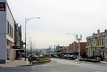
 William Street | |||||||||
| Coordinates | 33°25′12″S 149°34′40″E / 33.42000°S 149.57778°E | ||||||||
| Population | 36,230 (UCL 2021)[1] | ||||||||
| Established | 1814 | ||||||||
| Postcode(s) | 2795 | ||||||||
| Elevation | 650 m (2,133 ft) | ||||||||
| Location | |||||||||
| LGA(s) | Bathurst Regional Council | ||||||||
| Region | Central West | ||||||||
| State electorate(s) | Bathurst | ||||||||
| Federal division(s) | Calare | ||||||||
 | |||||||||
Bathurst (/ˈbæθɜːrst/) is a city in the Central Tablelands of New South Wales, Australia. Bathurst is about 200 kilometres (120 mi) west-northwest of Sydney and is the seat of the Bathurst Regional Council. Bathurst is the oldest inland settlement in Australia[2] and had a population of 37,396 in 2021.[3]
Bathurst is often referred to as the Gold Country as it was the site of the first gold discovery and where the first gold rush occurred in Australia. Today education, tourism and manufacturing drive the economy. The internationally known racetrack Mount Panorama is a landmark of the city. Bathurst has a historic city centre with many ornate buildings remaining from the New South Wales gold rush in the mid to late 19th century.
The median age of the city's population is 35 years; which is particularly young for a regional centre (the state median is 38), and is related to the large education sector in the community.[3][4] The city has had a moderate population growth of 1.29% year-on-year averaged over the five years until 2019, making Bathurst the tenth fastest-growing urban area in New South Wales outside Sydney.[3] This growth over recent years has resulted in increased urban development, including retail precincts, sporting facilities, housing estates and expanding industrial areas.
Geography

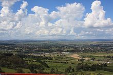
Bathurst is located on the western edge of the Great Dividing Range in the Macquarie River plain; also known as the Bathurst plains.[5]
The Macquarie River, which is part of the Murray-Darling basin, the largest river system in Australia, runs through the centre of the city. A number of levee banks have been erected in Bathurst to protect the region from occasional flood events.[6]
Mount Panorama is located 3 kilometres (1.9 mi) from the CBD and effectively within the city limits; it is 877 metres (2,877 ft) AMSL and rises 215 metres (705 ft) above the Bathurst CBD.
The Great Western Highway, which begins in the centre of the city of Sydney, ends at Bathurst. Two main state highways start at Bathurst: the Mitchell Highway to Bourke and the Mid-Western Highway to Hay. Bathurst is about mid-way along a regional road route from Canberra and Goulburn to Mudgee and the Hunter Region. Bathurst is also on the Main Western railway line that starts at Sydney Central and proceeds for 242 kilometres (150 mi) by rail to Bathurst.
The Macquarie River divides Bathurst with the CBD located on the western side of the river. Four road bridges and two rail bridges span the river within the city area. From the upstream side they are: Macquarie River Railway Bridge (built in 1876[7]) closed in 2011 (replaced with a new concrete single track rail bridge structure alongside and brought into use in 2011); the four lane Evans Bridge which opened in 1995; the Denison Bridge opened in 1870 (closed to road traffic and now a pedestrian bridge); the Gordon Edgell Bridge, a low−level bridge located on George Street; and Rankens Bridge at Eglinton.
Landform
Two physical components comprise the Bathurst region; the Bathurst Basin and the Tablelands areas. They are drained by the Macquarie, Turon, Fish and Campbells Rivers to the north and Abercrombie and Isabella Rivers to the south. The central basin area of the Bathurst area is mainly granite soils while in the north area sandstone, conglomerates, greywacke, siltstones, limestones and minor volcanos predominate. The south is more complex geology with siltstones, sandstones, greywacke, shales and chert, basalt and granite intrusions and embedded volcanic and limestones. Underlying Bathurst is the dominant feature of Bathurst granite (intruded in the Devonian period) and at Mount Panorama and Mount Stewart basalt occurs.[4]
Topography of the region ranges from slightly undulating to rough and very steep country, about 30 km to the east of Bathurst is the folded and faulted sedimentary and metamorphosed formations of the Great Dividing Range which runs roughly north–south.[8]
Central Business District and suburbs

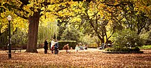
Bathurst's central business district (CBD) is located on William, George, Howick, Russell, and Durham Streets. The CBD is about 25 hectares (62 acres) in area and covers two city blocks. Banking, government services, shopping centres, retail shops, a park (shown) and monuments are in this area.
Bathurst has retained a mix of main street shopping along with enclosed shopping centres within the CBD, unlike other towns where the CBD focus has split between main street and new shopping centre developments located in the suburbs. Within the CBD lies Kings Parade; this is a park setting with several memorials of people and events in history. It is a popular location for locals to meet. Keppel Street is Bathurst's second commercial shopping area, removed from the CBD by two blocks to the south. This area developed once the railway arrived in 1876. [citation needed]
The main suburbs of Bathurst are: Kelso, Eglinton, West Bathurst, Llanarth, South Bathurst, Gormans Hill, Windradyne, Windradyne Heights and Abercrombie Estate. One of the newer suburbs is Marsden Estate, in Kelso.[9]
Climate

Due to its elevation, Bathurst has an oceanic climate (Cfb), according to the Köppen climate classification. Bathurst is in Australia's cool temperate climate zone which is defined as having mild to warm summers and cool to cold winters.[10][11] Regular summer thunderstorms are common, resulting from the flat plains country to the west, leading into the mountainous nature of the country around Bathurst and assisting the development of storm cells. These storms rarely strike the city and instead often move either in a south-east or north-east direction away from Bathurst.[12] Bathurst gets 106.9 clear days annually.[13]
In winter, light to moderate snowfalls occur each year on the high country around Bathurst, while snow is relatively rare in the city itself due to its low elevation at a northern latitude. On 5 July 1900, Bathurst received a freak snowfall measuring at 68 centimetres (27 in) in the main street.[14] Bathurst is relatively dry year round, as it lay in a rain shadow on account of its sheltered valley location flanked by hills and ranges on all sides.[15]
On 11 February 2017, Bathurst Ag recorded a new record high temperature of 41.5 °C (106.7 °F),[16] although temperatures of 40 °C (104 °F) are exceedingly rare for Bathurst. There is a reading of 44.7 °C (112.5 °F) on 12 January 1878 at the gaol, however such a reading may have been subject to overexposure. The highest minimum temperatures on record are 28.1 °C (82.6 °F) on 14 January 1939, and 27.8 °C (82.0 °F) on 20 November 1904.
The lowest recorded temperature was −10.6 °C (12.9 °F) on 31 July 1873; and the lowest maximum temperature was an extraordinary −0.8 °C (30.6 °F) on 18 June 1877, which is the only known daily maximum below 0 °C (32 °F) to have occurred in a major Australian city. Bathurst is one of only a handful of Australian towns to have recorded a sub-freezing maximum (others include Guyra and Nimmitabel), while at least one month has remained entirely free of air-frosts, a trait common in broadly-temperate Laurasian (European, Asian, and North American) climates.
| Climate data for Bathurst Agricultural Station (1991–2020, extremes 1908–2023); 713 m AMSL; 33.43° S, 149.56° E | |||||||||||||
|---|---|---|---|---|---|---|---|---|---|---|---|---|---|
| Month | Jan | Feb | Mar | Apr | May | Jun | Jul | Aug | Sep | Oct | Nov | Dec | Year |
| Record high °C (°F) | 41.0 (105.8) |
41.5 (106.7) |
36.7 (98.1) |
32.0 (89.6) |
25.0 (77.0) |
21.4 (70.5) |
20.5 (68.9) |
23.5 (74.3) |
31.2 (88.2) |
34.3 (93.7) |
39.7 (103.5) |
40.3 (104.5) |
41.5 (106.7) |
| Mean daily maximum °C (°F) | 29.5 (85.1) |
28.0 (82.4) |
25.1 (77.2) |
21.3 (70.3) |
16.7 (62.1) |
13.2 (55.8) |
12.3 (54.1) |
13.9 (57.0) |
17.3 (63.1) |
21.0 (69.8) |
24.2 (75.6) |
27.1 (80.8) |
20.8 (69.4) |
| Mean daily minimum °C (°F) | 14.0 (57.2) |
13.5 (56.3) |
10.5 (50.9) |
6.3 (43.3) |
2.9 (37.2) |
1.7 (35.1) |
0.6 (33.1) |
0.8 (33.4) |
3.1 (37.6) |
5.9 (42.6) |
9.2 (48.6) |
11.6 (52.9) |
6.7 (44.0) |
| Record low °C (°F) | 1.8 (35.2) |
2.8 (37.0) |
−2.2 (28.0) |
−5.0 (23.0) |
−6.7 (19.9) |
−9.2 (15.4) |
−8.9 (16.0) |
−7.5 (18.5) |
−6.0 (21.2) |
−3.9 (25.0) |
−1.1 (30.0) |
0.0 (32.0) |
−9.2 (15.4) |
| Average rainfall mm (inches) | 66.7 (2.63) |
63.9 (2.52) |
56.8 (2.24) |
32.9 (1.30) |
35.6 (1.40) |
43.4 (1.71) |
47.2 (1.86) |
46.3 (1.82) |
51.5 (2.03) |
57.2 (2.25) |
70.7 (2.78) |
75.5 (2.97) |
647.8 (25.50) |
| Average rainy days (≥ 0.2mm) | 8.1 | 7.5 | 7.0 | 5.3 | 7.7 | 10.8 | 11.4 | 10.2 | 9.3 | 9.1 | 9.8 | 8.8 | 105.0 |
| Average afternoon relative humidity (%) | 41 | 46 | 45 | 47 | 55 | 64 | 61 | 53 | 50 | 46 | 48 | 40 | 50 |
| Source: Bureau of Meteorology[13] | |||||||||||||
| Climate data for Bathurst Gaol (1858–1983); 704 m AMSL; 33.42° S, 149.55° E | |||||||||||||
|---|---|---|---|---|---|---|---|---|---|---|---|---|---|
| Month | Jan | Feb | Mar | Apr | May | Jun | Jul | Aug | Sep | Oct | Nov | Dec | Year |
| Record high °C (°F) | 44.7 (112.5) |
41.1 (106.0) |
37.7 (99.9) |
33.3 (91.9) |
26.7 (80.1) |
21.7 (71.1) |
21.1 (70.0) |
25.0 (77.0) |
30.0 (86.0) |
35.6 (96.1) |
39.7 (103.5) |
41.8 (107.2) |
44.7 (112.5) |
| Mean daily maximum °C (°F) | 29.3 (84.7) |
28.5 (83.3) |
26.0 (78.8) |
21.3 (70.3) |
16.6 (61.9) |
12.9 (55.2) |
12.0 (53.6) |
14.0 (57.2) |
17.5 (63.5) |
21.5 (70.7) |
25.0 (77.0) |
27.9 (82.2) |
21.0 (69.9) |
| Mean daily minimum °C (°F) | 13.2 (55.8) |
12.9 (55.2) |
10.5 (50.9) |
6.1 (43.0) |
2.7 (36.9) |
1.2 (34.2) |
0.1 (32.2) |
0.8 (33.4) |
3.0 (37.4) |
5.8 (42.4) |
8.7 (47.7) |
11.2 (52.2) |
6.4 (43.4) |
| Record low °C (°F) | −2.2 (28.0) Zdroj:https://en.wikipedia.org?pojem=Bathurst_Sports_Ground Text je dostupný za podmienok Creative Commons Attribution/Share-Alike License 3.0 Unported; prípadne za ďalších podmienok. Podrobnejšie informácie nájdete na stránke Podmienky použitia.
Analytika
Antropológia Aplikované vedy Bibliometria Dejiny vedy Encyklopédie Filozofia vedy Forenzné vedy Humanitné vedy Knižničná veda Kryogenika Kryptológia Kulturológia Literárna veda Medzidisciplinárne oblasti Metódy kvantitatívnej analýzy Metavedy Metodika Text je dostupný za podmienok Creative
Commons Attribution/Share-Alike License 3.0 Unported; prípadne za ďalších
podmienok. www.astronomia.sk | www.biologia.sk | www.botanika.sk | www.dejiny.sk | www.economy.sk | www.elektrotechnika.sk | www.estetika.sk | www.farmakologia.sk | www.filozofia.sk | Fyzika | www.futurologia.sk | www.genetika.sk | www.chemia.sk | www.lingvistika.sk | www.politologia.sk | www.psychologia.sk | www.sexuologia.sk | www.sociologia.sk | www.veda.sk I www.zoologia.sk | ||||||||||||

