

A | B | C | D | E | F | G | H | CH | I | J | K | L | M | N | O | P | Q | R | S | T | U | V | W | X | Y | Z | 0 | 1 | 2 | 3 | 4 | 5 | 6 | 7 | 8 | 9
Bad Kohlgrub | |
|---|---|
 Bad Kohlgrub from the northeast | |
 Coat of arms | |
Location of Bad Kohlgrub within Garmisch-Partenkirchen district 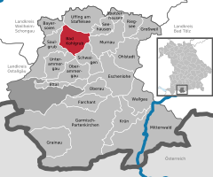 | |
 Bad Kohlgrub  Bad Kohlgrub | |
| Coordinates: 47°40′N 11°03′E / 47.667°N 11.050°E | |
| Country | Germany |
| State | Bavaria |
| Admin. region | Oberbayern |
| District | Garmisch-Partenkirchen |
| Government | |
| • Mayor (2018–24) | Franz Degele[1] (FW) |
| Area | |
| • Total | 32.66 km2 (12.61 sq mi) |
| Elevation | 828 m (2,717 ft) |
| Population (2022-12-31)[2] | |
| • Total | 2,869 |
| • Density | 88/km2 (230/sq mi) |
| Time zone | UTC+01:00 (CET) |
| • Summer (DST) | UTC+02:00 (CEST) |
| Postal codes | 82433 |
| Dialling codes | 08845 |
| Vehicle registration | GAP |
| Website | www.bad-kohlgrub.de |
Bad Kohlgrub is a German municipality in the district of Garmisch-Partenkirchen, in Bavaria. It lies 12 kilometres (7.5 mi) west of Murnau am Staffelsee and 8 kilometres (5.0 mi) north of Oberammergau, and is connected to both by the Ammergau Railway.
Skiing facilities include 4 ski lifts, 4 pistes and 30 kilometres (19 mi) of cross-country skiing trails.[3] A chairlift (opened 1954[4]) south of the town leads up to the Hörnlehütte below the summit of the Hörnle mountain (1,547 metres/5,075 ft).[5]
Transport
The municipality has two railway stations, Bad Kohlgrub and Bad Kohlgrub Kurhaus, on the Ammergau Railway.
References
- ^ Liste der ersten Bürgermeister/Oberbürgermeister in kreisangehörigen Gemeinden, Bayerisches Landesamt für Statistik, accessed 19 July 2021.
- ^ Genesis Online-Datenbank des Bayerischen Landesamtes für Statistik Tabelle 12411-003r Fortschreibung des Bevölkerungsstandes: Gemeinden, Stichtag (Einwohnerzahlen auf Grundlage des Zensus 2011) (Hilfe dazu).
- ^ "Bad Kohlgrub Ski Resort Guide". snow-forecast.com. Retrieved 1 September 2012.
- ^ "Hörnle chairlift". Ammergauer Alpen GmbH. Archived from the original on 10 February 2013. Retrieved 1 September 2012.
- ^ BY 7: Ammergebirge Ost, Pürschling. Hörnle (Map). 1:25000. Alpenvereinskarte Bayerische Alpen. Deutscher Alpenverein. 2009.
Towns and municipalities in Garmisch-Partenkirchen (district) | ||
|---|---|---|
 | ||
| International | |
|---|---|
| National | |
| Geographic | |
This Garmisch-Partenkirchen district location article is a stub. You can help Wikipedia by expanding it. |
Text je dostupný za podmienok Creative Commons Attribution/Share-Alike License 3.0 Unported; prípadne za ďalších podmienok. Podrobnejšie informácie nájdete na stránke Podmienky použitia.
Antropológia
Aplikované vedy
Bibliometria
Dejiny vedy
Encyklopédie
Filozofia vedy
Forenzné vedy
Humanitné vedy
Knižničná veda
Kryogenika
Kryptológia
Kulturológia
Literárna veda
Medzidisciplinárne oblasti
Metódy kvantitatívnej analýzy
Metavedy
Metodika
Text je dostupný za podmienok Creative
Commons Attribution/Share-Alike License 3.0 Unported; prípadne za ďalších
podmienok.
Podrobnejšie informácie nájdete na stránke Podmienky
použitia.
www.astronomia.sk | www.biologia.sk | www.botanika.sk | www.dejiny.sk | www.economy.sk | www.elektrotechnika.sk | www.estetika.sk | www.farmakologia.sk | www.filozofia.sk | Fyzika | www.futurologia.sk | www.genetika.sk | www.chemia.sk | www.lingvistika.sk | www.politologia.sk | www.psychologia.sk | www.sexuologia.sk | www.sociologia.sk | www.veda.sk I www.zoologia.sk