

A | B | C | D | E | F | G | H | CH | I | J | K | L | M | N | O | P | Q | R | S | T | U | V | W | X | Y | Z | 0 | 1 | 2 | 3 | 4 | 5 | 6 | 7 | 8 | 9
Atascosa County | |
|---|---|
County | |
 The Atascosa County Courthouse in Jourdanton | |
 Location within the U.S. state of Texas | |
 Texas's location within the U.S. | |
| Coordinates: 28°53′N 98°32′W / 28.89°N 98.53°W | |
| Country | |
| State | |
| Founded | 1856 |
| Named for | Atascosa River |
| Seat | Jourdanton |
| Largest city | Pleasanton |
| Area | |
| • Total | 1,221 sq mi (3,160 km2) |
| • Land | 1,210 sq mi (3,100 km2) |
| • Water | 1.9 sq mi (5 km2) 0.2% |
| Population (2020) | |
| • Total | 48,981[1] |
| • Density | 40.2/sq mi (15.5/km2) |
| Time zone | UTC−6 (Central) |
| • Summer (DST) | UTC−5 (CDT) |
| Congressional district | 28th |
| Website | atascosacounty |
Atascosa County (/ˌætəsˈkoʊsə/ AT-əs-KOH-sə) is a county located in the U.S. state of Texas. It is in South Texas and its county seat is Jourdanton.[2]
As of the 2020 United States Census, its population was 48,981.[3][4] Atascosa County is part of the San Antonio-New Braunfels metropolitan statistical area.
History
In 1856, the Texas Legislature established Atascosa County from portions of Bexar County and named it for the Atascosa River.
Geography
According to the United States Census Bureau, the county has a total area of 1,221 square miles (3,160 km2), of which 1.9 square miles (4.9 km2) (0.2%) are covered by water.[5]
The county contains rolling hills and knolls, sloped to the southeast. It is drained by the Atascosa River, which exits the county at its southeastern corner.[6] The highest point is a localized hill near the northeastern border with Bexar County, between Lytle and Somerset in Bexar, at 810 ft (250 m) above sea level.[7]
Major highways
Adjacent counties
- Bexar County - north
- Wilson County - northeast
- Karnes County - east
- Live Oak County - southeast
- McMullen County - south
- La Salle County - southwest
- Frio County - west
- Medina County - northwest
Demographics
| Census | Pop. | Note | %± |
|---|---|---|---|
| 1860 | 1,578 | — | |
| 1870 | 2,915 | 84.7% | |
| 1880 | 4,217 | 44.7% | |
| 1890 | 6,459 | 53.2% | |
| 1900 | 7,143 | 10.6% | |
| 1910 | 10,004 | 40.1% | |
| 1920 | 12,702 | 27.0% | |
| 1930 | 15,654 | 23.2% | |
| 1940 | 19,275 | 23.1% | |
| 1950 | 20,048 | 4.0% | |
| 1960 | 18,828 | −6.1% | |
| 1970 | 18,696 | −0.7% | |
| 1980 | 25,055 | 34.0% | |
| 1990 | 30,533 | 21.9% | |
| 2000 | 38,628 | 26.5% | |
| 2010 | 44,911 | 16.3% | |
| 2020 | 48,981 | 9.1% | |
| 2021 (est.) | 49,939 | [3] | 2.0% |
| U.S. Decennial Census[8] 1850–2010[9] 2010[10] 2020[11] | |||
| Race / Ethnicity | Pop 2010[10] | Pop 2020[11] | % 2010 | % 2020 |
|---|---|---|---|---|
| White alone (NH) | 16,295 | 16,066 | 36.28% | 32.80% |
| Black or African American alone (NH) | 256 | 340 | 0.57% | 0.69% |
| Native American or Alaska Native alone (NH) | 143 | 116 | 0.32% | 0.24% |
| Asian alone (NH) | 130 | 170 | 0.29% | 0.35% |
| Pacific Islander alone (NH) | 14 | 15 | 0.03% | 0.03% |
| Some other race alone (NH) | 43 | 177 | 0.10% | 0.36% |
| Mixed/multiracial (NH) | 245 | 919 | 0.55% | 1.88% |
| Hispanic or Latino (any race) | 27,785 | 31,178 | 61.87% | 63.65% |
| Total | 44,911 | 48,981 | 100.00% | 100.00% |
As of the 2010 United States census, 44,911 people resided in the county; 84.9% were White, 0.8% Black or African American, 0.8% Native American, 0.3% Asian, 0.1% Pacific Islander, 10.9% of some other race, and 2.3% of two or more races. About 61.9% were Hispanics or Latinos (of any race).
As of the 2000 United States census,[12] 38,628 people, 12,816 households, and 10,022 families were in the county. The population density was 31 people per square mile (12 people/km2). The 14,883 housing units had an average density of 12 per square mile (4.6/km2). The racial makeup of the county was 73.23% White, 0.60% African American, 0.80% Native American, 0.31% Asian, 21.6% from other races, and 3.47% from two or more races. About 58.56% of the population were Hispanics or Latinos of any race.
Of the 12,816 households, 41.7% had children under 18 living with them, 60.3% were married couples living together, 13.0% had a female householder with no husband present, and 21.8% were not families. About 18.9% of all households were made up of individuals, and 8.7% had someone living alone who was 65 or older. The average household size was 2.99, and the average family size was 3.41.
The age distribution was 31.7% under 18, 8.9% from 18 to 24, 27.6% from 25 to 44, 21.0% from 45 to 64, and 10.8% who were 65 or older. The median age was 32 years. For every 100 females, there were 96.60 males. For every 100 females 18 and over, there were 94.20 males.
The median income for a household in the county was $33,081, and for a family was $37,705. Males had a median income of $27,702 versus $18,810 for females. The per capita income for the county was $14,276. About 16.10% of families and 20.20% of the population were below the poverty line, including 25.60% of those under age 18 and 21.70% of those age 65 or over.
Education
These school districts serve Atascosa County:[13]
- Charlotte Independent School District (partial)
- Jourdanton Independent School District
- Karnes City Independent School District (partial)
- Lytle Independent School District (partial)
- Pleasanton Independent School District
- Poteet Independent School District
- Somerset Independent School District (partial)
Most of the county is in the service area of Alamo Community College District. The portion in Pleasanton ISD is zoned to Coastal Bend College (formerly Bee County College).[14]
Communities
Cities
- Charlotte
- Jourdanton (county seat)
- Lytle (partly in Medina and Bexar counties)
- Pleasanton
- Poteet
Town
Census-designated place
Unincorporated communities
Ghost towns
Gallery
-
 Atascosa County has long been cattle country
 -
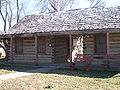 Replica of the original Atascosa County log courthouse in Jourdanton
 -
 The old Atascosa County Jail in Jourdanton was used from 1911 to 1982
 -
 The Atascosa County Sheriff's Office and Jail in Jourdanton is located behind the old log courthouse
 -

-
 Sign at Trinity Baptist Church in Lytle


Politics
United States presidential election results
| Year | Republican | Democratic | Third party | |||
|---|---|---|---|---|---|---|
| No. | % | No. | % | No. | % | |
| 2020 | 12,039 | 66.37% | 5,876 | 32.40% | 223 | 1.23% |
| 2016 | 8,618 | 63.03% | 4,651 | 34.02% | 404 | 2.95% |
| 2012 | 7,461 | 58.65% | 5,133 | 40.35% | 127 | 1.00% |
| 2008 | 5,462 | 54.96% | 4,415 | 44.43% | 61 | 0.61% |
| 2004 | 7,635 | 63.02% | 4,421 | 36.49% | 60 | 0.50% |
| 2000 | 6,231 | 57.98% | 4,322 | 40.22% | 193 | 1.80% |
| 1996 | 4,102 | 44.33% | 4,259 | 46.02% | 893 | 9.65% |
| 1992 | 3,806 | 39.41% | 3,766 | 38.99% | 2,086 | 21.60% |
| 1988 | 4,777 | 50.26% | 4,657 | 49.00% | 70 | 0.74% |
| 1984 | 5,279 | 59.68% | 3,547 | 40.10% | 19 | 0.21% |
| 1980 | 4,364 | 51.53% | 3,980 | 46.99% | 125 | 1.48% |
| 1976 | 2,415 | 34.15% | 4,565 | 64.55% | 92 | 1.30% |
| 1972 | 3,400 | 65.28% | 1,804 | 34.64% | 4 | 0.08% |
| 1968 | 1,805 | 35.41% | 2,522 | 49.47% | 771 | 15.12% |
| 1964 | 1,283 | 28.41% | 3,224 | 71.39% | 9 | 0.20% |
| 1960 | 1,812 | 41.55% | 2,544 | 58.34% | 5 | 0.11% |
| 1956 | 1,804 | 54.55% | 1,492 | 45.12% | 11 | 0.33% |
| 1952 | 2,147 | 50.15% | 2,124 | 49.61% | 10 | 0.23% |
| 1948 | 704 | 25.77% | 1,895 | 69.36% | 133 | 4.87% |
| 1944 | 685 | 25.89% | 1,757 | 66.40% | 204 | 7.71% |
| 1940 | 418 | 17.83% | 1,922 | 82.00% | 4 | 0.17% |
| 1936 | 285 | 12.13% | 2,041 | 86.85% | 24 | 1.02% |
| 1932 | 192 | 8.32% | 2,101 | 91.07% | 14 | 0.61% |