A | B | C | D | E | F | G | H | CH | I | J | K | L | M | N | O | P | Q | R | S | T | U | V | W | X | Y | Z | 0 | 1 | 2 | 3 | 4 | 5 | 6 | 7 | 8 | 9
Aklan | |
|---|---|
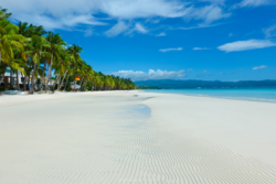
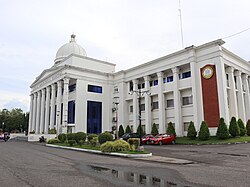
(from top: left to right) Boracay Island, Kalibo Cathedral, Ati-atihan Festival, Aklan Museum, Kalibo Bakhawan Eco Park, and Aklan Provincial Capitol. | |
| Nickname: Oldest Province in the Philippines | |
| Motto(s): "Arangkada, Aklan" | |
| Anthem: "Aklan Hymn" | |
 Location in the Philippines | |
| Coordinates: 11°40′N 122°20′E / 11.67°N 122.33°E | |
| Country | Philippines |
| Region | Western Visayas |
| First settled | 1213 |
| Founded | 25 April 1956 |
| Capital and largest municipality | Kalibo |
| Government | |
| • Governor | Jose Enrique M. Miraflores (PDP–Laban ) |
| • Vice Governor | Reynaldo M. Quimpo (NP) |
| • Legislature | Aklan Provincial Board |
| Area | |
| • Total | 1,821.42 km2 (703.25 sq mi) |
| • Rank | 64th out of 81 |
| Highest elevation | 1,777 m (5,830 ft) |
| Population (2020 census)[2] | |
| • Total | 615,475 |
| • Rank | 51st out of 81 |
| • Density | 340/km2 (880/sq mi) |
| • Rank | 23rd out of 81 |
| Demonym | Aklanon |
| Divisions | |
| • Independent cities | 0 |
| • Component cities | 0 |
| • Municipalities | |
| • Barangays | 327 |
| • Districts | Legislative districts of Aklan |
| Time zone | UTC+8 (PHT) |
| ZIP Code | 5600–5616 |
| IDD : area code | +63 (0)36 |
| ISO 3166 code | PH-AKL |
| HDI | |
| HDI rank | 29th in Philippines (2019) |
| Spoken languages | |
| Website | aklan |
Aklan, officially the Province of Aklan (Akeanon: Probinsya it Akean ; Hiligaynon: Kapuoran sang Aklan; Tagalog: Lalawigan ng Aklan), is a province in the Western Visayas region of the Philippines. Its capital is Kalibo. The province is situated in the northwest portion of Panay Island, bordering Antique to the southwest, and Capiz to the southeast. Aklan faces the Sibuyan Sea and Romblon province to the north.
Aklan is most well-known for Boracay, a resort island 0.8 kilometer north of the tip of Panay. It is known for its white sand beaches and is considered one of the more prominent destinations in the country. The Ati-Atihan Festival of Kalibo has also been known worldwide, hence declared "The Mother of all Philippine Festivals." It is an annual celebration held on the third Sunday of January to honor the Santo Niño (Infant Jesus). The festival showcases tribal dancing through the town's main streets to the tune of ethnic music, with participants in indigenous costumes and gear.[3]
History
This section needs additional citations for verification. (June 2021) |
Early history
Aklan is believed to have been settled in the 13th century by settlers from Borneo, ruled by the chieftain Datu Dinagandan which traded with its neighbouring islands. Aklan then became a part of the Kedatuan of Madja-as. Towards the end of the 13th century, Datu Dinagandan moved the capital from what is now Batan.
In 1433, Datu Kalantiaw's grandson and successor, Datu Kalantiaw III, was said by Jose Marcos to have formulated a set of laws known today as the Code of Kalantiaw. Well-respected scholarly long-term Philippine resident historian William Henry Scott proved these "laws" to be a total fabrication.[4][5][6][7]
In 1437, the short-lived dynasty of Datu Kalantiaw ended when Datu Kalantiaw III was killed in battle with the tribes of Datu Manduyog, the legitimate successor of Datu Dinagandan. When Datu Manduyog became the new chieftain, he moved the capital to Bakan (now known as Banga).
Spanish colonial era
Several datus succeeded Datu Manduyog until the Spanish explorer Miguel López de Legazpi landed in Batan in 1565 and claimed the island for Spain, in early Spanish accounts it was called El Río de Aclán. Datu Kabanyag was the chieftain at that period and had his capital in Libacao.
Japanese occupation era
In 1942, the Japanese invaded Aklan during World War II. In 1945, combined Filipino and American army along with Aklanon guerrillas liberated Aklan during the war in the Pacific.[citation needed]
Philippine independence
Aklan (Akean) became an independent province through Republic Act No. 1414 signed by Philippine President Ramon Magsaysay on April 25, 1956, separating Aklan from Capiz.[8] The original towns were Altavas, Balete, Batan, Banga, Buruanga, Ibajay, Kalibo, Lezo, Libacao, Madalag, Malay, Makato, Malinao, Nabas, New Washington, Numancia, and Tangalan, then all part of the province of Capiz. The province was inaugurated on November 8, 1956. Jose Raz Menez was appointed the first governor of Aklan by President Magsaysay and he served until December 30, 1959.
In 1960, Godofredo P. Ramos became the first elected governor but upon resigning to run for Congress he was succeeded by the vice governor, Virgilio S. Patricio. In 1964, José B. Legaspi succeeded Patricio and he held office for two consecutive terms from 1964 to 1971.[citation needed]
Geography

Aklan occupies the northern third of the island of Panay and is bordered by the provinces of Capiz from the southeast and Antique from the southwest. It also faces the Sibuyan Sea from the north. The province covers a total area of 1,821.42 square kilometres (703.25 sq mi)[9], and includes the island of Boracay which is located at its northwestern tip.
Mount Nausang, is formerly the highest peak in Aklan, standing at 5,190 ft (1,580 m), the discovery of Mount Timbaban is much higher, with an elevation of 5,830.1 ft (1,777.0 m) above sea level, Mount Timbaban is not considered as independent mountain, it is still part of Mount Madja-as sub-summit with only Topographic prominence peak of 30 m (98 ft) above the isolation from the Parent peak. Located 6 km northwest of Mount Nausang and 4.8 km northeast of Mount Madja-as in Antique. Aklan River, is the longest river in the province with a total length of 91 km (57 mi) long.
The province features high geographic diversity, ranging from white sandy beaches, mangroves and mountainous landscapes. Situated within the province is the river Akean, which appears unique due to its "boiling or frothing" appearance.
Administrative divisions
Aklan comprises 17 municipalities.[9] The province is divided into two legislative districts for congressional representation.[9]

| Municipality[i] | Population | ±% p.a. | Area[9] | Density (2020) | Barangay | |||||||
|---|---|---|---|---|---|---|---|---|---|---|---|---|
| (2020)[2] | (2015)[10] | km2 | sq mi | /km2 | /sq mi | |||||||
| 11°32′14″N 122°29′17″E / 11.5373°N 122.4881°E | Altavas | 4.2% | 25,639 | 24,619 | +0.78% | 109.05 | 42.10 | 240 | 620 | 14 | ||
| 11°33′23″N 122°22′47″E / 11.5564°N 122.3797°E | Balete | 4.9% | 30,090 | 28,920 | +0.76% | 118.93 | 45.92 | 250 | 650 | 10 | ||
| 11°38′18″N 122°19′56″E / 11.6382°N 122.3322°E | Banga | 6.6% | 40,318 | 39,505 | +0.39% | 84.53 | 32.64 | 480 | 1,200 | 30 | ||
| 11°35′13″N 122°29′46″E / 11.5869°N 122.4962°E | Batan | 5.4% | 33,484 | 32,032 | +0.85% | 79.22 | 30.59 | 420 | 1,100 | 20 | ||
| 11°50′39″N 121°53′18″E / 11.8442°N 121.8884°E | Buruanga | 3.1% | 19,357 | 19,003 | +0.35% | 56.44 | 21.79 | 340 | 880 | 15 | ||
| 11°49′06″N 122°09′54″E / 11.8184°N 122.1649°E | Ibajay | 8.5% | 52,364 | 49,564 | +1.05% | 158.90 | 61.35 | 330 | 850 | 35 | ||
| 11°42′32″N 122°21′50″E / 11.7089°N 122.3640°E | Kalibo | † | 14.5% | 89,127 | 80,605 | +1.93% | 50.75 | 19.59 | 1,800 | 4,700 | 16 | |
| 11°40′04″N 122°19′43″E / 11.6679°N 122.3286°E | Lezo | 2.5% | 15,639 | 15,224 | +0.51% | 23.40 | 9.03 | 670 | 1,700 | 12 | ||
| 11°28′50″N 122°18′09″E / 11.4806°N 122.3024°E | Libacao | 4.6% | 28,272 | 28,241 | +0.02% | 254.98 | 98.45 | 110 | 280 | 24 | ||
| 11°31′37″N 122°18′23″E / 11.5269°N 122.3063°E | Madalag | 3.1% | 18,890 | 18,389 | +0.51% | 269.60 | 104.09 | 70 | 180 | 25 | ||
| 11°42′42″N 122°17′33″E / 11.7116°N 122.2926°E | Makato | 4.8% | 29,717 | 27,262 | +1.66% | 103.45 | 39.94 | 290 | 750 | 18 | ||
| 11°54′01″N 121°54′36″E / 11.9002°N 121.9100°E | Malay | 9.8% | 60,077 | 52,973 | +2.43% | 66.01 | 25.49 | 910 | 2,400 | 17 | ||
| 11°38′38″N 122°18′27″E / 11.6439°N 122.3076°E | Malinao | 4.0% | 24,517 | 23,194 | +1.06% | 186.01 | 71.82 | 130 | 340 | 23 | ||
| 11°49′44″N 122°05′36″E / 11.8288°N 122.0933°E | Nabas | 6.6% | 40,632 | 36,435 | +2.10% | 96.82 | 37.38 | 420 | 1,100 | 20 | ||
| 11°38′50″N 122°26′08″E / 11.6473°N 122.4356°E | New Washington | 7.8% | 47,955 | 45,007 | +1.22% | 66.69 | 25.75 | 720 | 1,900 | 16 | ||
| 11°42′21″N 122°19′41″E / 11.7058°N 122.3280°E | Numancia | 5.8% | 35,693 | 31,934 | +2.14% | 28.84 | 11.14 | 1,200 | 3,100 | 17 | ||
| 11°46′26″N 122°15′37″E / 11.7740°N 122.2604°E | Tangalan | 3.9% | 23,704 | 21,916 | +1.50% | 62.03 | 23.95 | 380 | 980 | 15 | ||
| Total | 615,475 | 574,823 | +1.31% | 1,760.30 | 679.66 | 350 | 910 | 327 | ||||
| † Provincial capital | Municipality | |||||||||||
| ||||||||||||
Demographics
| Year | Pop. | ±% p.a. |
|---|---|---|
| 1903 | 110,773 | — |
| 1918 | 137,323 | +1.44% |
| 1939 | 176,625 | +1.21% |
| 1948 | 196,982 | +1.22% |
| 1960 | 226,232 | +1.16% |
| 1970 | 263,358 | +1.53% |
| 1975 | 293,349 | +2.19% |
| 1980 | 324,563 | +2.04% |
| 1990 | 380,497 | +1.60% |
| 1995 | 410,539 | +1.43% |
| 2000 | 451,314 | +2.05% |
| 2007 | 495,122 | +1.29% |
| 2010 | 535,725 | +2.91% |
| 2015 | 574,823 | +1.35% |
| 2020 | 615,475 | +1.35% |
| Source: Philippine Statistics Authority[10][11][11] | ||
The population of Aklan in the 2020 census was 615,475 people,[2] with a density of 340 inhabitants per square kilometre or 880 inhabitants per square mile.
Ethnic groups
The main inhabitants of the province are the Aklanon, who are part of the Visayan ethnic group. Other inhabitants include the Negrito, locally known as the Ati and the Sulod, a lesser known tribal group living in the hinterlands of Panay. Other Visayans also present are the Hiligaynon, Karay-a, and Capiznon.


