A | B | C | D | E | F | G | H | CH | I | J | K | L | M | N | O | P | Q | R | S | T | U | V | W | X | Y | Z | 0 | 1 | 2 | 3 | 4 | 5 | 6 | 7 | 8 | 9
Yadkin County | |
|---|---|
 Yadkin County Courthouse | |
| Motto(s): "Come for a visit, stay for a lifetime" | |
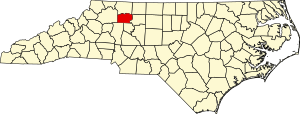
 Location within the U.S. state of North Carolina | |
 North Carolina's location within the U.S. | |
| Coordinates: 36°10′N 80°40′W / 36.16°N 80.67°W | |
| Country | |
| State | |
| Founded | 1850 |
| Named for | Yadkin River |
| Seat | Yadkinville |
| Largest community | Yadkinville |
| Area | |
| • Total | 337.71 sq mi (874.7 km2) |
| • Land | 334.94 sq mi (867.5 km2) |
| • Water | 2.77 sq mi (7.2 km2) 0.82% |
| Population (2020) | |
| • Total | 37,214 |
| • Estimate (2023) | 37,774 |
| • Density | 111.11/sq mi (42.90/km2) |
| Time zone | UTC−5 (Eastern) |
| • Summer (DST) | UTC−4 (EDT) |
| Congressional district | 5th |
| Website | www |
Yadkin County is a county located in the U.S. state of North Carolina. As of the 2020 census, the population was 37,214.[1] Its county seat is Yadkinville.[2] Yadkin County is included in the Winston-Salem, NC Metropolitan Statistical Area, which is also included in the Greensboro–Winston-Salem–High Point, NC Combined Statistical Area.
History
What is now Yadkin County was home to the Tutelo and Saponi Indian tribes.[3] European-descent settlers moved into the area around 1748. Though in a part of the Piedmont region of the state, the residents of the eventual county developed more economic, political, and cultural similarities with their contemporaries in the mountains to the west than to many of their peers in other sections of the Piedmont or those in the eastern part of North Carolina.[4] Over the following decades the county developed as a society mostly made up of smallholding white farmers, though Yadkin was also home to several large landowners and slaveholders (and their slaves), some working professionals, and a few free blacks and Native Americans.[5]
The land eventually comprising Yadkin County was first politically organized under the jurisdiction of Anson County.[4] In 1750, it was placed in the new jurisdiction of Rowan County, and in 1770 was made a part of Surry County. In 1850, the North Carolina General Assembly split off the portion of Surry south of the Yadkin River to create Yadkin County to satisfy local political divisions.[6] At the time of its creation, the county had 9,808 residents, of whom 8,664 were white, 86 were free persons of color, and 1,508 were enslaved blacks.[7] The town of Wilson was established to serve as the county seat. In 1852 the town's name was changed to Yadkinville.[8]

From 1850 to 1860 the county experienced economic and demographic growth. By the end of the decade, though it was still mostly rural and dominated by farming, the county hosted several grist mills, stores, distilleries, and a tobacco factory.[9] Politically, the county was home to many Whigs and its resident favored John Bell of the Constitutional Union Party during the 1860 United States presidential election.[10] Following the election of Republican Abraham Lincoln as president, leaders of the state of North Carolina considered whether or not to secede in 1861 and join the nascent Confederate States of America. Yadkin voters overwhelming rejected a vote to hold a state convention to consider secession.[11][12] Following Lincoln's call for Southern volunteers to suppress rebellion in South Carolina, a state convention was held and North Carolina seceded from the United States.[13]
Men from Yadkin County served during the ensuing American Civil War in the Confederate States Army. Many would desert and return home to assist their families in key agricultural activities before going back into service.[14] North Carolina's declaration of a draft proved unpopular in the county;[15] some locals avoided conscription into the army due to pro-Union sentiments, or, in the case of local Quakers, due to religious objections to war and slavery. Some draft dodgers hid in woods or caves, while others fled west to pro-Union communities in the mountains.[16] In February 1863, two Confederate officials and two draft evaders were killed in an exchange of gunfire after a militia attempted to arrest a group of evaders at a school house.[17][18]
After the war, Yadkin became politically dominated by the Republican Party, with many locals being attracted to it for its opposition to slavery, support for central national government, and push for disbursing money to fund infrastructure improvements.[19] Yadkin's support for the Republican Party persisted along with some of its neighboring counties after the state largely fell under the Democratic Party's domination in the 1870s.[20] Portions of Yadkin County were annexed to Forsyth County in 1911 and 1927.[21] The county garnered its first paved highways in the 1920s.[22]
By the mid-20th century, Yadkin's economy was largely rooted in tobacco farming. Many residents not employed by the agricultural industry commuted to Winston-Salem in Forsyth County for work. In 1971, Unifi Manufacturing established its first textile facility in Yadkin County. As the company expanded over the following decades, it became the leading industrial employer the county and provided additional economic support through tax revenue and philanthropy to the area. National declines in the textiles industry in the late 1990s and early 2000s led the company to shrink its local presence.[23]
Geography
According to the U.S. Census Bureau, the county has a total area of 337.71 square miles (874.7 km2), of which 334.94 square miles (867.5 km2) is land and 2.77 square miles (7.2 km2) (0.82%) is water.[24] It is bordered by Surry, Forsyth, Davie, Iredell, and Wilkes counties.[3]
Yadkin County is located in the Piedmont region of North Carolina and in the northwestern portion of state, close to the Blue Ridge Mountains.[3] The western portions of the county are hillier than the eastern portions,[4] with part of the Brushy Mountains crossing into the northwestern section.[25] It is within the Yadkin-Pee Dee River Basin,[3] with the Yadkin River forming its northern and eastern borders.[26]
State and local protected areas
Major water bodies
- Beaverdam Creek
- Deep Creek
- Dobbins Creek
- Forbush Creek
- Harmon Creek
- Little Forbush Creek
- Logan Creek
- Miller Creek
- North Deep Creek
- North Little Hunting Creek[27]
- South Deep Creek
- South Yadkin River
- Turner Creek
- Yadkin River
Demographics
| Census | Pop. | Note | %± |
|---|---|---|---|
| 1860 | 10,714 | — | |
| 1870 | 10,697 | −0.2% | |
| 1880 | 12,420 | 16.1% | |
| 1890 | 13,790 | 11.0% | |
| 1900 | 14,083 | 2.1% | |
| 1910 | 15,428 | 9.6% | |
| 1920 | 16,391 | 6.2% | |
| 1930 | 18,010 | 9.9% | |
| 1940 | 20,657 | 14.7% | |
| 1950 | 22,133 | 7.1% | |
| 1960 | 22,804 | 3.0% | |
| 1970 | 24,599 | 7.9% | |
| 1980 | 28,439 | 15.6% | |
| 1990 | 30,488 | 7.2% | |
| 2000 | 36,348 | 19.2% | |
| 2010 | 38,406 | 5.7% | |
| 2020 | 37,214 | −3.1% | |
| 2023 (est.) | 37,774 | [1] | 1.5% |
| U.S. Decennial Census[28] 1790–1960[29] 1900–1990[30] 1990–2000[31] 2010[32] 2020[1] | |||
2020 census
| Race | Number | Percentage |
|---|---|---|
| White (non-Hispanic) | 30,357 | 81.57% |
| Black or African American (non-Hispanic) | 1,071 | 2.88% |
| Native American | 63 | 0.17% |
| Asian | 142 | 0.38% |
| Other/Mixed | 1,199 | 3.22% |
| Hispanic or Latino | 4,382 | 11.78% |
As of the 2020 census, there were 37,214 people, 15,425 households, and 10,789 families residing in the county.
2000 census
At the 2000 census,[34] there were 36,348 people, 14,505 households, and 10,588 families residing in the county. The population density was 108 people per square mile (42 people/km2). There were 15,821 housing units at an average density of 47 units per square mile (18 units/km2). The racial makeup of the county was 92.54% White, 3.43% Black or African American, 0.16% Native American, 0.17% Asian, 0.02% Pacific Islander, 2.91% from other races, and 0.77% from two or more races. 6.48% of the population were Hispanic or Latino of any race.
There were 14,505 households, out of which 32.10% had children under the age of 18 living with them, 60.00% were married couples living together, 9.00% had a female householder with no husband present, and 27.00% were non-families. 24.00% of all households were made up of individuals, and 10.50% had someone living alone who was 65 years of age or older. The average household size was 2.47 and the average family size was 2.92.
In the county, the population was spread out, with 24.00% under the age of 18, 7.50% from 18 to 24, 30.20% from 25 to 44, 24.20% from 45 to 64, and 14.20% who were 65 years of age or older. The median age was 38 years. For every 100 females there were 96.40 males. For every 100 females age 18 and over, there were 93.60 males.
The median income for a household in the county was $36,660, and the median income for a family was $43,758. Males had a median income of $29,589 versus $22,599 for females. The per capita income for the county was $18,576. About 7.10% of families and 10.00% of the population were below the poverty line, including 10.90% of those under age 18 and 17.40% of those age 65 or over.
Law and government
Government
Yadkin County is governed by a five-member board of commissioners who are elected at-large to serve staggered two- and four-year terms. Elections are held in November of even-numbered years.[35] The commissioners appoint a county manager, who serves as the head administrator of the county government.[36]
Yadkin County is a member of the Northwest Piedmont Council of Governments, a regional planning association.[37] It is located entirely in the North Carolina Senate's 36th district, the North Carolina House of Representatives' 77th district,[38] and North Carolina's 5th congressional district.[39]
Yadkin County lies within the bounds of North Carolina's 34th Prosecutorial District, the 23rd Superior Court District, and the 23rd District Court District.[40]
Politics
| Historical presidential election returns | |||||||||||||||||||||||||||||||||||||||||||||||||||||||||||||||||||||||||||||||||||||||||||||||||||||||||||||||||||||||||||||||||||||||||||||||
| |||||||||||||||||||||||||||||||||||||||||||||||||||||||||||||||||||||||||||||||||||||||||||||||||||||||||||||||||||||||||||||||||||||||||||||||


