

A | B | C | D | E | F | G | H | CH | I | J | K | L | M | N | O | P | Q | R | S | T | U | V | W | X | Y | Z | 0 | 1 | 2 | 3 | 4 | 5 | 6 | 7 | 8 | 9
Newburyport, Massachusetts | |
|---|---|
City | |
 Seal | |
 Location in Essex County and the state of Massachusetts | |
 Newburyport, Massachusetts Location in the United States | |
| Coordinates: 42°48′45″N 70°52′40″W / 42.81250°N 70.87778°W | |
| Country | United States |
| State | Massachusetts |
| County | Essex |
| Settled | 1635 |
| Incorporated as a town | 1764 |
| Incorporated as a city | 1851 |
| Government | |
| • Type | Mayor-council city |
| • Mayor | Sean R. Reardon |
| Area | |
| • Total | 10.71 sq mi (27.74 km2) |
| • Land | 8.35 sq mi (21.63 km2) |
| • Water | 2.36 sq mi (6.11 km2) |
| Elevation | 37 ft (11 m) |
| Population (2020) | |
| • Total | 18,289 |
| • Density | 2,190.30/sq mi (845.66/km2) |
| Time zone | UTC−5 (Eastern) |
| • Summer (DST) | UTC−4 (Eastern) |
| ZIP Code | 01950 |
| Area code | 351/978 |
| FIPS code | 25-45245 |
| GNIS feature ID | 0614293 |
| Website | www |
Newburyport is a coastal city in Essex County, Massachusetts, United States, 35 miles (56 km) northeast of Boston. The population was 18,289 at the 2020 census.[2] A historic seaport with a vibrant tourism industry, Newburyport includes part of Plum Island. The mooring, winter storage, and maintenance of recreational boats, motor and sail, still contribute a large part of the city's income. A Coast Guard station oversees boating activity, especially in the sometimes dangerous tidal currents of the Merrimack River.
At the edge of the Newbury Marshes, delineating Newburyport to the south, an industrial park provides a wide range of jobs. Newburyport is on a major north-south highway, Interstate 95. The outer circumferential highway of Boston, Interstate 495, passes nearby in Amesbury. The Newburyport Turnpike (U.S. Route 1) still traverses Newburyport on its way north. The Newburyport/Rockport MBTA commuter rail from Boston's North Station terminates in Newburyport. The earlier Boston and Maine Railroad leading farther north was discontinued, but a portion of it has been converted into a recreation trail.
History


On January 28, 1764, the General Court of Massachusetts passed "An act for erecting part of the town of Newbury into a new town by the name of Newburyport."[3] The act begins:
Whereas the town of Newbury is very large, and the inhabitants of that part of it who dwell by the water-side there, as it is commonly called, are mostly merchants, traders and artificers, and the inhabitants of the other parts of the town are chiefly husbandmen; by means whereof many difficulties and disputes have arisen in managing their public affairs – Be it enacted ... That that part of the said town of Newbury ... be and hereby are constituted and made a separate and distinct town ....
The act was approved by Governor Francis Bernard on February 4, 1764. The new town was the smallest in Massachusetts, covering an area of 647 acres (2.62 km2), and had a population of 2,800 living in 357 homes. There were three shipyards, no bridges, and several ferries, one of which at the foot of Greenleaf Lane, now State Street,[4] carried the Portsmouth Flying Stage Coach, running between Portsmouth, New Hampshire, and Boston.[5]
The town prospered and became a city in 1851. Situated near the mouth of the Merrimack River, it was once a fishing, shipbuilding and shipping center, with an industry in silverware manufacture. In 1792, a bridge was built two miles above the town where the river contained an island.[6] Merrimack Arms and Brown Manufacturing Company made Southerner Derringer pistols in their Newburyport factory from 1867 to 1873.[7] The sea captains of old Newburyport (as elsewhere in Massachusetts) had participated vigorously in the triangular trade, importing West Indian molasses and exporting rum made from it. The distilleries were located around Market Square near the waterfront. Caldwell's Old Newburyport rum was manufactured locally until 1961.
As a part of the triangle trade, the first leg of the which involved the purchase of slaves from West Africa, many Newburyporters were anti-abolitionist. Massachusetts abolished slavery in 1783, and many runaway slaves found refuge in the state. In the early 1800s, there were around 6000 runaway slaves living in Newburyport. In 1850, the fugitive slave act was passed, requiring all US states to capture and return runaway slaves. Because of this, runaways had to flee the country or risk return to slavery. In this era, some white Newburyporters became stops on the Underground Railroad. As a port city and part of the triangle trade, Newburyport's abolitionists were often mariners. Capt. Alexander Graves, for example, smuggled slaves from the South and to Canada.[8]
Newburyport once had a fishing fleet that operated from Georges Bank to the mouth of the Merrimack River. It was a center for privateering during the Revolutionary War and War of 1812. Beginning about 1832, it added numerous ships to the whaling fleet. Later, clipper ships were built there. Today, the city gives little hint of its former maritime importance. Notably missing are the docks, which are shown on earlier maps extending into the channel of the Merrimack River, and the shipyards, where the waterfront parking lot is currently located.
George Whitefield, the well-known and influential English preacher who helped inspire the First Great Awakening in America, arrived in Newburyport in September 1740. The revival that followed his labors, brought into existence Old South Church, where he was buried after his death in 1770.
The city's historical highlights include:
Historic events:
- First of many clipper ships built here[9]
- First "Tea Party" rebellion to oppose British Tea Tax[10][11]
- First state mint and treasury building[12]
- Newburyport Superior Courthouse, the oldest continuously active courthouse in Massachusetts
The Newburyport Five Cents Savings Bank on State Street was founded in 1854, and is one of the oldest banks in the United States still in operation.[13]
Historic houses and museums:
- Cushing House Museum & Garden[14] (c. 1808)
- Newburyport Custom House Museum[15] (1835), designed by Robert Mills
Literary interests:
- Was referred to in the H. P. Lovecraft story, "The Shadow Over Innsmouth", as being located near Innsmouth. Lovecraft in fact based his depiction of Innsmouth largely on Newburyport.[16]
- Subject of the most ambitious community study ever undertaken, the Yankee City project conducted by anthropologist W. Lloyd Warner and his associates
Timeline
- 1635: Newbury incorporated.[17]
- 1761: Belleville Congregational Church founded.[18][19]
- 1764: Newburyport incorporated (formerly part of Newbury).
- 1772: Marine Society of Newburyport established.[20]
- 1773
- Isaiah Thomas opens "a printing house in King Street."[21]
- Essex Journal newspaper begins publication.[22][23]
- 1790: Population: 4,837.[24]
- 1793: Impartial Herald newspaper begins publication.[22][23]
- 1794
- 1795
- 1797: Newburyport Herald newspaper begins publication.[23]
- 1799: Newburyport Marine Insurance Co. incorporated.[25]
- 1801: American Intelligencer newspaper published.[23]
- 1802: Merrimac Humane Society established.[26]
- 1803
- 1804: Political Calendar newspaper begins publication.[23]
- 1805: Merrimack Magazine begins publication.[23]
- 1807: Newburyport Gazette newspaper begins publication.[23]
- 1808: Statesman newspaper begins publication.[23]
- 1810
- 1812: Washington Benevolent Society organized.[25]
- 1818: Howard Benevolent Society instituted "for the relief of the sick and destitute."[26]
- 1825: Newburyport Hosiery Co. established.[25]
- 1829: Newburyport Lyceum organized.[25]
- 1835
- Society for the Relief of Aged Females founded.[25][26]
- U.S. Custom House built.[27]
- 1836
- 1837: Bartlet Steam Mills incorporated.[25]
- 1840: Pleasant Street Christian Church organized.[26]
- 1841: Essex North District Medical Society organized.[26]
- 1842: James Steam Mills incorporated.[25]
- 1844: Essex Steam Mills incorporated.[25]
- 1845: Globe Steam Mills and Ocean Steam Mills incorporated.[25]
- 1850
- 1851: June 18: Essex North Musical convention held.[25]
- 1852: Merrimack Library Association organized.[25]
- 1854
- Newburyport Public Library founded.[25]
- Newburyport Five Cents Savings Bank incorporated.[25]
- 1855: Newburyport Library Association organized.[25]
- 1857: Mechanic Library Association incorporated.[25]
- 1865: Washington Street Methodist Episcopal Church organized.[26]
- 1869: Merrimack Marine Railway Co. incorporated.[25]
- 1874: Newburyport Mutual Benefit Association organized.[26]
- 1877: Antiquarian and Historical Society of Old Newbury established.[25][28][29]
- 1878: Newburyport Athenaeum organized.[25]
- 1884: Newburyport YMCA incorporated.[25]
- 1886: Newburyport Society for the Relief of Aged Men incorporated.[25]
- 1887: Newburyport Electric Light & Power Co. incorporated.[25]
- 1888: Daily News established.
- 1890
- 1896: Newburyport Choral Union organized.[25]
- 1904: South End Reading Room Association formed.[25]
- 1906: Newburyport Homeoepathic Hospital opens.[25]
- 1917: Annunciation Greek Orthodox Church of Newburyport founded.
- 1968: Newburyport Maritime Society established.[27]
- 1971: Market Square Historic District added to National Register of Historic Places.
- 1971-1979: Downtown undergoes major renewal and historic preservation effort.
- 1991: Actors Studio of Newburyport founded.[30][31]
- 1994: Sister city relationship established with Bura, Taita-Taveta District, Kenya.[32][33]
Historic preservation
Despite its former prosperity, in the 1950s and 1960s Newburyport's center fell into disrepair because of several factors, most notably strip malls taking away from local business and increased use of the automobile. At this time, construction of major highways brought larger cities such as Lawrence and Lowell into shopping range. Consequently, by 1970 Newburyport's historic downtown section was scheduled to be razed prior to reconstruction with federal money. Ideas to rebuild the city's downtown were numerous, ranging from hotels and new stores to, ironically, a strip mall, with few buildings left for historical reasons. At the last moment, however, the city changed its mind and signed a federal grant that allowed it to keep most of its historic architecture. Renovation and restorations began during the early 1970s, and continued throughout most of the decade, initially along State Street, and culminating with creation of a pedestrian mall along Inn Street. Newburyport is often cited as an example by preservationists of how to maintain a city's architecture and heritage, while still having it remain functional and liveable.
-
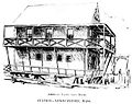 American Yacht Club House c. 1894
 -
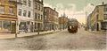 State Street c. 1906. Except for the trolley, the store fronts, and the pavement, the street has not changed.
 -
 Dexter House c. 1908, once home to eccentric "Lord" Timothy Dexter
 -
 Frog Pond c. 1905. High Street is visible in the background. The building in the center is the old court house.
 -
 Joppa Landing c. 1906. The boats are fishing dories. The houses remain but the landing and the boats are gone and the street has been improved.
 -
 City Hall c. 1910. The building looks about the same today. It was constructed 1850–1851. The corner of Brown Square is visible across the street. The view is from where the Post Office now stands.
 -
 Brown Square in 1913, viewed from before the City Hall. The statue is that of "Garrison the Liberator". The houses and church still stand but the street has been paved and more modern buildings inserted.


Geography

Newburyport is located at 42°48′45″N 70°52′39″W / 42.81250°N 70.87750°W (42.812391, −70.877440).[34] According to the United States Census Bureau, the city has a total area of 10.6 square miles (27 km2), of which 8.4 square miles (22 km2) is land and 2.2 square miles (5.7 km2) (20.77%) is water.
The city is part of Massachusetts' North Shore; Newburyport was laid out on the elevated south bank of the Merrimack River between the river and Newbury marshes. The shipyards, now boatyards (and still vigorously active), extended along the bank at the edge of the river. They were connected by Merrimac Street, which ends upriver where the bank merges into bluffs covered with pine forest. Colonial residences extend up the bank from Merrimac Street to High Street running parallel to it near the top of the ridge. The homes of the seafaring entrepreneurs line High Street. Many feature widow's walks, structures on the roof where the residents could watch for the return of sailing vessels. Nearly every home maintains a splendid flower garden, most dating to colonial times. Various cross streets, such as State Street, Green Street and Market Street, connect Merrimac Street and High Street. The top of the ridge proved an ideal location for later institutions, such as Newburyport High School and nearby Anna Jaques Hospital. The ridge drops more sharply to the marsh on the other side. Along its margin a third parallel street developed, Low Street.
The river bank gradually descends to marshes at Joppa Flats beyond downtown Newburyport. The Plum Island Turnpike was pushed out over the marsh on a causeway to a narrow part of the Plum Island River just to the south of where it connects to the mouth of the Merrimack. A drawbridge was built there, the only access to the island by road. On the Newburyport side a small airport, Plum Island Airport, was built at the edge of the marsh. The portion of Plum Island that is in the city has no direct access to the rest of the city; similarly, there is no access between the mainland and Woodbridge Island or Seal Island, west of Plum Island (the latter being shared between Newburyport and Newbury). Several parks and beaches dot the city, including Plum Island Point Beach, Simmons Beach, Joppa Park, Waterfront Park, Woodman Park, Cashman Park, Moseley Pines Park and Atkinson Common and March's Hill Park. Newburyport Forest is located in the southwest corner of the city, and Maudslay State Park lies along the northwest part of the city, along the banks of the Merrimack.
Newburyport is located 37 miles (60 km) north-northeast of Boston, 19 miles (31 km) east-northeast of Lawrence, and 21 miles (34 km) south-southeast of Portsmouth, New Hampshire. Situated 5 miles (8 km) south of the New Hampshire border, the city is bordered by the Gulf of Maine (Atlantic Ocean) to the east, Newbury to the south and southeast, West Newbury to the west and southwest, Amesbury to the north and northwest, and Salisbury to the northeast.
Neighborhoods
Joppa: Joppa is bordered by Newbury to the southeast, the South End to the southwest, and Downtown to the Northwest. This is the closest neighborhood to Plum Island Airport located in Newbury.
South End: The South End is bordered by Newbury to the south, Joppa to the northeast, and Downtown to the northwest. The border between the South End and Joppa is just behind Hancock Street, Chestnut Street, and, Part of Prospect Street.
Climate
| Climate data for Newburyport, Massachusetts (2000–2016 normals, rainfall/snowfall 1991–2020; extremes 1911–2016) | |||||||||||||
|---|---|---|---|---|---|---|---|---|---|---|---|---|---|
| Month | Jan | Feb | Mar | Apr | May | Jun | Jul | Aug | Sep | Oct | Nov | Dec | Year |
| Record high °F (°C) | 71 (22) |
67 (19) |
85 (29) |
94 (34) |
100 (38) |
97 (36) |
100 (38) |
98 (37) |
96 (36) |
86 (30) |
75 (24) |
70 (21) |
100 (38) |
| Mean maximum °F (°C) | 55 (13) |
54 (12) |
65 (18) |
83 (28) |
88 (31) |
92 (33) |
94 (34) |
92 (33) |
90 (32) |
79 (26) |
69 (21) |
60 (16) |
96 (36) |
| Mean daily maximum °F (°C) | 33.2 (0.7) |
36.2 (2.3) |
44.5 (6.9) |
56.6 (13.7) |
66.5 (19.2) |
75.0 (23.9) |
82.3 (27.9) |
81.0 (27.2) |
74.1 (23.4) |
61.9 (16.6) |
51.5 (10.8) |
40.2 (4.6) |
58.6 (14.8) |
| Daily mean °F (°C) | 24.2 (−4.3) |
26.5 (−3.1) |
34.9 (1.6) |
45.6 (7.6) |
55.9 (13.3) |
64.9 (18.3) |
71.8 (22.1) |
70.1 (21.2) |
63.1 (17.3) |
51.6 (10.9) |
41.8 (5.4) |
31.6 (−0.2) |
48.5 (9.2) |
| Mean daily minimum °F (°C) | 15.2 (−9.3) |
16.8 (−8.4) |
25.3 (−3.7) |
34.6 (1.4) |
45.3 (7.4) |
54.9 (12.7) |
61.3 (16.3) |
59.2 (15.1) |
52.1 (11.2) |
41.3 (5.2) |
32.2 (0.1) |
23.0 (−5.0) |
38.4 (3.6) |
| Mean minimum °F (°C) | −2 (−19) |
2 (−17) |
8 (−13) |
25 (−4) |
32 (0) |
44 (7) |
53 (12) |
50 (10) |
39 (4) |
29 (−2) |
19 (−7) |
9 (−13) |
−4 (−20) |
| Record low °F (°C) | −12 (−24) |
−12 (−24) |
−2 (−19) |
19 (−7) |
28 (−2) |
39 (4) |
48 (9) |
46 (8) |
32 (0) |
25 (−4) |
12 (−11) |
−2 (−19) |
−12 (−24) |
| Average precipitation inches (mm) | 3.68 (93) |
3.63 (92) |
4.72 (120) |
4.45 (113) |
4.11 (104) |
4.27 (108) |
3.51 (89) |
3.49 (89) |
3.90 (99) |
5.15 (131) |
3.99 (101) |
4.86 (123) |
49.76 (1,262) |
| Average snowfall inches (cm) | 18.0 (46) |
16.1 (41) |
13.4 (34) |
1.8 (4.6) |
0.0 (0.0) |
0.0 (0.0) |
0.0 (0.0) |
0.0 (0.0) |
0.0 (0.0) |
0.1 (0.25) |
1.4 (3.6) |
11.1 (28) |
61.9 (157.45) |
| Average extreme snow depth inches (cm) | 11.0 (28) |
12.0 (30) |
10.0 (25) |
2.0 (5.1) |
0.0 (0.0) |
0.0 (0.0) |
0.0 (0.0) |
0.0 (0.0) |
0.0 (0.0) |
0.0 (0.0) |
1.0 (2.5) |
7.0 (18) |
18.0 (46) |
| Average precipitation days (≥ 0.01 in) | 11.5 | 9.3 | 11.6 | 10.9 | 12.0 | 11.9 | 10.2 | 9.4 | 9.1 | 10.6 | 10.4 | 11.5 | 128.4 |
| Average snowy days (≥ 0.1 in) | 6.9 | 5.3 | 4.6 | 0.8 | 0.0 | 0.0 | 0.0 | 0.0 | 0.0 | 0.1 | 1.0 | 4.5 | 23.2 |
| Source: NOAA[35][36] | |||||||||||||
Demographics
| Year | Pop. | ±% |
|---|---|---|
| 1790 | 4,837 | — |
| 1800 | 5,946 | +22.9% |
| 1810 | 7,634 | +28.4% |
| 1820 | 6,852 | −10.2% |
| 1830 | 6,375 | −7.0% |
| 1840 | 7,161 | +12.3% |
| 1850 | 9,572 | +33.7% |
| 1860 | 13,401 | +40.0% |
| 1870 | 12,595 | −6.0% |
| 1880 | 13,538 | +7.5% |
| 1890 | 13,947 | +3.0% |
| 1900 | 14,478 | +3.8% |
| 1910 | 14,949 | +3.3% |
| 1920 | 15,618 | +4.5% |
| 1930 | 15,084 | −3.4% |
| 1940 | 13,916 | −7.7% |
| 1950 | 14,111 | +1.4% |
| 1960 | 14,004 | −0.8% |
| 1970 | 15,807 | +12.9% |
| 1980 | 15,900 | +0.6% |
| 1990 | 16,317 | +2.6% |
| 2000 | 17,189 | +5.3% |
| 2010 | 17,416 | +1.3% |
| 2020 | 18,289 | +5.0% |
| 2022 | 18,662 | +2.0% |
| * = population estimate. Source: United States census records and Population Estimates Program data.[37][38][39][40][41][42][43][44][45][46][47][48] Source: U.S. Decennial Census[49] | ||
As of the census[50] of 2010, there were 17,416 people, 8,264 households, and 4,428 families residing in the city. The population density was 2,086.2 inhabitants per square mile (805.5/km2). There were 7,897 housing units at an average density of 942.0 per square mile (363.7/km2). The racial makeup of the city was 90.2% White, 3.6% African American, 0.1% Native American, 0.61% Asian, 0.01% Pacific Islander, 0.16% from other races, and 1.2% from two or more races. Hispanic or Latino people of any race were 2.7% of the population. The top five ethnic groups are:[51] (United States 2010 Census quickfacts)
- Irish – 25%
- English – 16%
- Italian – 11%
- French (except Basque) – 7%
- German – 6%
There were 7,519 households, out of which 25.9% had children under the age of 18 living with them, 47.7% were married couples living together, 8.5% had a female householder with no husband present, and 41.1% were non-families. Of all households 33.1% were made up of individuals, and 9.7% had someone living alone who was 65 years of age or older. The average household size was 2.24 and the average family size was 2.90.
In the city, the population was spread out, with 20.7% under the age of 18, 4.4% from 18 to 24, 32.7% from 25 to 44, 28.2% from 45 to 64, and 14.0% who were 65 years of age or older. The median age was 41 years. For every 100 females, there were 86.7 males. For every 100 females age 18 and over, there were 82.9 males.
The median income for a household in the city was $78,557, and the median income for a family was $103,306. Males had a median income of $51,831 versus $37,853 for females. The per capita income for the city was $34,187. About 2.8% of families and 5.2% of the population were below the poverty line, including 4.5% of those under age 18 and 6.9% of those age 65 or over.
Government
Upon adopting a new charter in 2011 which took effect in 2013, Newburyport has been run by a mayor with a four-year term and an eleven-member City Council (prior to that, the mayor's term lasted for two years). During the mid-twentieth century, Newburyport enjoyed a typical "small community" approach, conducted, most notably, by city mayor and activist Ed Molin, who died in 2005. The current mayor of Newburyport is Sean Reardon, and the next election year for mayor is 2025.
Newburyport is part of the Massachusetts Senate's 1st Essex district.[52]
| Voter registration and party enrollment as of October 15, 2008[53] | |||||
|---|---|---|---|---|---|
| Party | Number of voters | Percentage | |||
| Democratic | 4,058 | 31.42% | |||
| Republican | 1,700 | 13.16% | |||
| Unaffiliated | 7,095 | 54.94% | |||
| Libertarian | 61 | 0.47% | |||
| Total | 12,914 | 100% | |||
Transportation
Interstate 95 passes through the western side of town, with one exit at Route 113. Route 113 itself has its eastern terminus at U.S. Route 1 and Massachusetts Route 1A, with Route 1A continuing along the same right of way as 113 towards Newbury. Route 1 and 1A cross the river along the Newburyport Turnpike Bridge; it had originally followed State Street and ended at Merrimac and Water streets before crossing the river via ferry to Salisbury. The Turnpike Bridge is the easternmost crossing of the Merrimack; upstream the river is crossed by the Newburyport Railroad Bridge (just west of the Turnpike Bridge), the Chain Bridge, one of the oldest bridges along the river, and the Whittier Memorial Bridge, which brings Interstate 95 to Amesbury.
The Merrimack Valley Regional Transit Authority provides regular bus service between the city and Haverhill, which includes access to the commuter rail station in Newburyport. The bus costs $1.25 for adults paying cash and $1 for adults paying with CharlieCard. C&J[54] and Coach Company,[55] privately operated coach carriers, operate commuter bus services between Newburyport and Boston. Newburyport is the northern terminus of the Newburyport/Rockport Line of the MBTA Commuter Rail system, providing access through several North Shore cities to Boston's North Station.[56]
Plum Island Airport is a privately owned general aviation airport located within the city limits. It is open to the public and managed by Plum Island Aerodrome, Inc., a not-for-profit organization.[57] The nearest scheduled commercial air service can be found at Boston's Logan International Airport, Worcester's Worcester Regional Airport, Portsmouth's Pease International Tradeport or Manchester's Manchester-Boston Regional Airport.
Education

The current site of Newburyport High School was purchased from Harvard University early in the 20th century.[citation needed] Newburyport High School is one of the oldest public high schools in the United States.
Newburyport is served by several public schools, belonging to the Newburyport School District, and several private schools.
- Francis T. Bresnahan Lower Elementary School: pre-kindergarten to grade 3
- Edward G. Molin Upper Elementary School: grades 4 and 5
- Rupert A. Nock Middle School: grades 6 to 8
- Newburyport High School: grades 9 to 12
- River Valley Charter School: grades kindergarten to 8 Zdroj:https://en.wikipedia.org?pojem=Newburyport
Text je dostupný za podmienok Creative Commons Attribution/Share-Alike License 3.0 Unported; prípadne za ďalších podmienok. Podrobnejšie informácie nájdete na stránke Podmienky použitia.
Antropológia
Aplikované vedy
Bibliometria
Dejiny vedy
Encyklopédie
Filozofia vedy
Forenzné vedy
Humanitné vedy
Knižničná veda
Kryogenika
Kryptológia
Kulturológia
Literárna veda
Medzidisciplinárne oblasti
Metódy kvantitatívnej analýzy
Metavedy
Metodika
Text je dostupný za podmienok Creative
Commons Attribution/Share-Alike License 3.0 Unported; prípadne za ďalších
podmienok.
Podrobnejšie informácie nájdete na stránke Podmienky
použitia.
www.astronomia.sk | www.biologia.sk | www.botanika.sk | www.dejiny.sk | www.economy.sk | www.elektrotechnika.sk | www.estetika.sk | www.farmakologia.sk | www.filozofia.sk | Fyzika | www.futurologia.sk | www.genetika.sk | www.chemia.sk | www.lingvistika.sk | www.politologia.sk | www.psychologia.sk | www.sexuologia.sk | www.sociologia.sk | www.veda.sk I www.zoologia.sk